Torres Strait
A thousand-reef corridor where tides sculpt the last strongholds of tropical octopus.

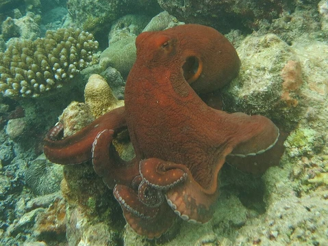
The Torres Strait is the roughly 130-kilometre-wide marine corridor separating the Cape York Peninsula of Queensland, Australia, from the southern coast of Papua New Guinea. It comprises a dense archipelago of more than 700 islands, fringing coral reefs, extensive seagrass meadows, and mangrove estuaries, all threaded by strong tidal channels. For marine cephalopods—particularly reef-associated octopuses—the strait functions as a transitional biogeographic zone where Indo-Pacific and Australasian faunas overlap, offering a mosaic of microhabitats within a relatively compact area.
Ecologically, the strait's high tidal ranges, warm tropical waters, and structural complexity (live coral, rubble, sand, mangrove roots) create the kind of heterogeneous, predator-rich environment in which many octopus species exploit cryptic colouration, substrate manipulation, and short-range dispersal. It is also a living cultural landscape: the Torres Strait Islands have been continuously inhabited by Torres Strait Islander peoples for millennia, and traditional marine tenure systems still shape local access to reef and lagoon resources.
- Region
- Between Queensland, Australia and Papua New Guinea
- Island count
- 700+
- Ecosystem types
- Coral reef, mangrove, seagrass, open water
- Tidal range (major channels)
- Up to ~10 m
- Water temperature
- Tropical (warm, low seasonality)
- Cultural context
- Torres Strait Islander traditional sea country
Lore & Background
The Torres Strait sits at the seam of two oceanic provinces. Warm, nutrient-poor water from the Coral Sea meets cooler, upwelling-influenced flows from the Gulf of Carpentaria, and the resulting mixing zone supports high primary productivity in channels and lagoons. For a small, territorial octopus this means a landscape of alternating hard and soft substrates: a coral bommie with a tangled tangle of branching Acropora, a few metres of fine sand, then a mangrove root tangle where the water barely moves at low tide. Each microhabitat favours a different foraging strategy—pincer-and-squeeze on reef invertebrates, rapid sand-digging for buried bivalves, or slow ambush among pneumatophores.
The strait's tidal regime is among the most extreme in the world; in the main channels the water can rise and fall by several metres within six hours. Octopuses that occupy the intertidal fringe must time their foraging to slack water and retreat into crevices or burrows as the current surges back. This rhythmic pulse also drives the movement of their prey—crabs, small fish, and molluscs—making the strait a place where a cephalopod's daily activity is essentially a negotiation with the tide clock.
Human presence is inseparable from the ecology here. Torres Strait Islander communities have managed reef and lagoon resources for generations, and contemporary marine protected-area design in the strait still incorporates traditional tenure boundaries. Conservation status of individual octopus species in the strait is generally data-limited, but the broad reef and mangrove habitats they depend on are subject to cyclone damage, sedimentation, and shifting shipping-lane pressures.
Reader's Guide
Coral-reef flats and bommies (0–15 m): The primary foraging and shelter zone. Octopuses occupy crevices, under overhangs, and within branching coral tangles where they can grip with suckers and flash colour-matching chromatophores. Substrate is live coral, rubble, or encrusted dead coral. Seasonal cyclone events can restructure these microhabitats, forcing short-range relocation.
Sandy channels and reef margins (5–25 m): Fine to medium sand over a hard substrate edge. Here octopuses dig shallow burrows or lie flat, using a 'sand-burial' strategy to ambush benthic invertebrates. The strong tidal flow in major strait channels (up to ~10 m range) means activity peaks at slack water.
Mangrove and seagrass margins (0–5 m): Root tangles and seagrass beds provide shelter for juveniles and a foraging ground for small crustaceans. Water is calmer, often slightly turbid. These zones are ecologically significant as nursery habitat and as a buffer against sedimentation from shipping lanes.
Open-water and lagoon edges (10–40 m): Less commonly used by small reef octopuses but relevant during dispersal or after storm disturbance. The strait's mixing of Coral Sea and Gulf of Carpentaria waters creates localised productivity patches that draw prey aggregations.
Did You Know?
- The Torres Strait's tidal range in its main channels can exceed 10 metres, making it one of the most tidally extreme reef environments on Earth and a major driver of octopus foraging rhythms.
- More than 700 islands dot the strait, each contributing reef, mangrove, or lagoon habitat, so a single octopus population can span a surprisingly wide mosaic of microhabitats within a few kilometres.
- The strait is a biogeographic transition zone where Indo-Pacific and Australasian marine faunas overlap, meaning species composition shifts noticeably across just a few degrees of latitude.
- Torres Strait Islander traditional sea-country management has shaped local reef and lagoon access for millennia, and modern marine-protected-area design in the region still incorporates those tenure boundaries.
More in Distribution & Habitat
Elsewhere in Big blue octopus
Spotted an error? Know more?
Reader corrections go straight into our review queue. Suggest an edit · How this site is sourced