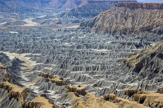
Ravine
A narrow, steep-sided valley formed by water erosion.

A ravine is a steep-sided landform, narrower than a canyon and wider than a gully, but smaller than a valley. It typically forms through streambank erosion. The sides of a ravine are relatively steep, with a gradient between twenty and seventy percent. A ravine may or may not contain an active stream in the channel that originally carved it; because of their size, they often only support intermittent streams rather than permanent ones.
Other names for a ravine include cleuch, dene, dean, dell, ghout (Nevis), gill, ghyll, glen, goyle, gorge, kloof (South Africa), and chine (Isle of Wight). According to Merriam-Webster, a ravine is "a small, narrow, steep-sided valley that is larger than a gully and smaller than a canyon and that is usually worn by running water." Some languages and societies do not distinguish between a gully and a ravine, while others do, especially in environmental management contexts.
Gullies typically appear in hilly or mountainous areas, where runoff erodes the landscape over time. A ravine represents the final stage of gully erosion, occurring when a stream cuts a deep channel into the earth. A gully is classified as a ravine once it reaches a depth greater than about 5 meters (16 feet).
Ravine erosion is a major cause of land loss worldwide, particularly threatening farmland. The resulting soil loss contributes to pollution, flooding, and sedimentation in waterways. Deforestation and overgrazing can accelerate ravine formation. In Indian badlands, soil erosion rates vary widely depending on region and conditions, with some studies reporting figures exceeding 40 tonnes per hectare annually in specific areas.
In Hawaii, the shield volcanoes Mauna Loa and Mauna Kea influence ravine distribution. V-shaped ravines appear on their flanks in various settings, not limited to areas mantled by Pahala ash. Mauna Kea, being older, shows more pronounced ravine dissection. Rainfall and infiltration capacity are key to valley initiation on these volcanoes; once valleys form, streams cut V-shaped ravines. As these deepen, they can expose groundwater, but the deepest incisions typically remain V-shaped ravines rather than transitioning to U-shaped, theatre-headed valleys.
- Field
- Geomorphology
- Known for
- Steep-sided erosional landform intermediate between gully and canyon
- Typical gradient
- 20–70%
- Minimum depth for classification
- 5 meters (16 feet)
- Alternative names
- cleuch, dene, dean, dell, ghout, gill, ghyll, glen, goyle, gorge, kloof, chine
Lore & Background
Ravines are formed as the final step in gully erosion, when a stream erodes so severely it creates a deep cut in the earth. A gully can be classified as a ravine after it reaches a depth typically in excess of 5 meters. They are often found in hilly or mountainous regions, where water runoff is guided downhill by steep slopes and over time erodes the landscape. Ravines may be characterized by intermittent streams, since their geographic scale may not be sufficiently large to support a perennial stream.
In Hawaii, the shield volcanoes Mauna Loa and Mauna Kea show V-shaped ravines on their flanks in various locations, not solely where they have been mantled by Pahala ash. Mauna Kea, being the older of the two, displays more pronounced dissection of these ravines. Rainfall and infiltration capacity are critical to valley initiation on these volcanoes; once valleys are initiated, streams incise to form V-shaped ravines, which may deepen further but typically remain V-shaped rather than becoming U-shaped, theatre-headed valleys.
Ravine erosion contributes heavily to land loss globally and particularly threatens farmland. In Indian badlands, reported soil erosion rates vary widely depending on the specific region and study, with some estimates exceeding 40 tonnes per hectare annually in certain areas.
Reader's Guide
Ravines are significant as a key stage in fluvial erosion, bridging the scale between gullies and valleys. Their steep sides and intermittent streams make them distinct landforms that pose challenges for land management, especially in agriculture. The environmental impact of ravine erosion is substantial: it contributes to land loss, pollution, flooding, and sedimentation of waterways. Human activities such as deforestation and overgrazing can accelerate ravine formation, as seen in Indian badlands where soil erosion rates exceed 40 tonnes per hectare annually. The study of ravines also provides insights into volcanic landscapes, as demonstrated by the V-shaped ravines on Hawaii's Mauna Loa and Mauna Kea, where ash mantling and rainfall patterns control valley initiation and dissection. The terminology for ravines varies across regions and languages, with some societies not differentiating between gullies and ravines, while others make a distinction important for environmental management. Overall, ravines represent a dynamic interface between water flow, slope stability, and human land use.
Did You Know?
- A ravine is narrower than a canyon and larger than a gully.
- Ravines may also be called a cleuch, dene, dean, dell, ghout, gill, ghyll, glen, goyle, gorge, kloof, or chine.
- In Indian badlands, soil erosion from ravines is estimated to exceed 40 tonnes per hectare annually.
Frequently Asked Questions
What is a ravine in geomorphology?
A ravine is a narrow, steep-walled channel in the landscape that sits between a gully and a canyon in terms of size. It is carved primarily by flowing water wearing away the streambanks over time.
How do I tell a ravine apart from a canyon or a gully?
Size is the key differentiator—a ravine is wider than a gully but narrower than a canyon, and it must be at least five meters (about 16 feet) deep to qualify. Its walls typically slope at angles between twenty and seventy percent.
What is the typical gradient of a ravine's sides?
The steep banks of a ravine usually fall within a twenty-to-seventy-percent slope range. This makes them noticeably steeper than a gentle valley but not as sheer as a cliff face.
Does a ravine always have a stream running through it?
Not necessarily—many ravines only carry water during or after rainfall rather than year-round. Their modest size means they often support seasonal or intermittent flow rather than a permanent watercourse.
What other names are used for a ravine in different regions?
Depending on where you are, the same landform might be called a gill, ghyll, glen, dene, dell, cleuch, or gorge. In South Africa it is known as a kloof, and on the Isle of Wight the local term is chine.
More in Geomorphology 1-24
Spotted an error? Know more?
Reader corrections go straight into our review queue. Suggest an edit · How this site is sourced