Mudcrack
Sedimentary structures formed by drying and contraction of mud.

Rygel, M.C. · CC BY-SA 4.0
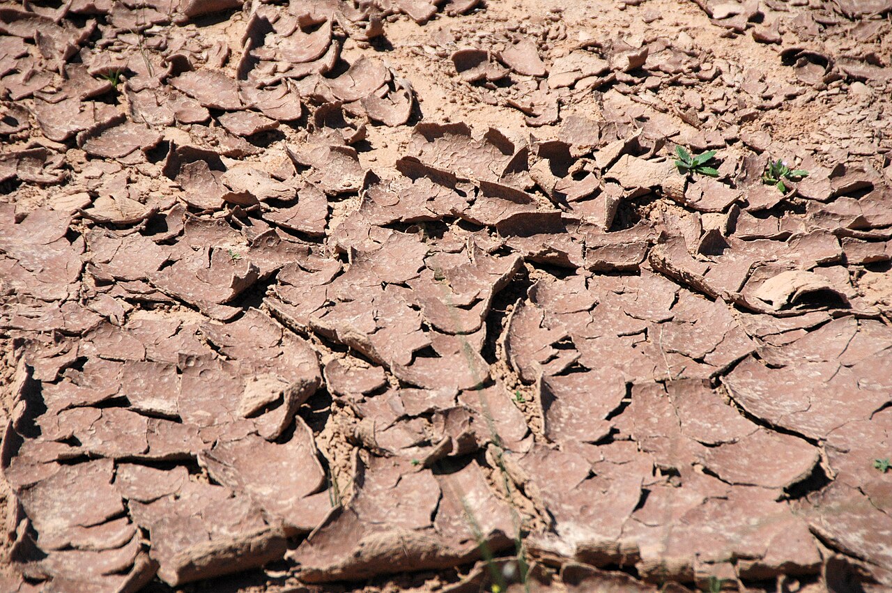
Mudcracks—also called mud cracks, desiccation cracks, or cracked mud—are sedimentary structures that appear when muddy sediment dries out and shrinks. The same kind of cracking happens in clay-rich soils as water content drops.
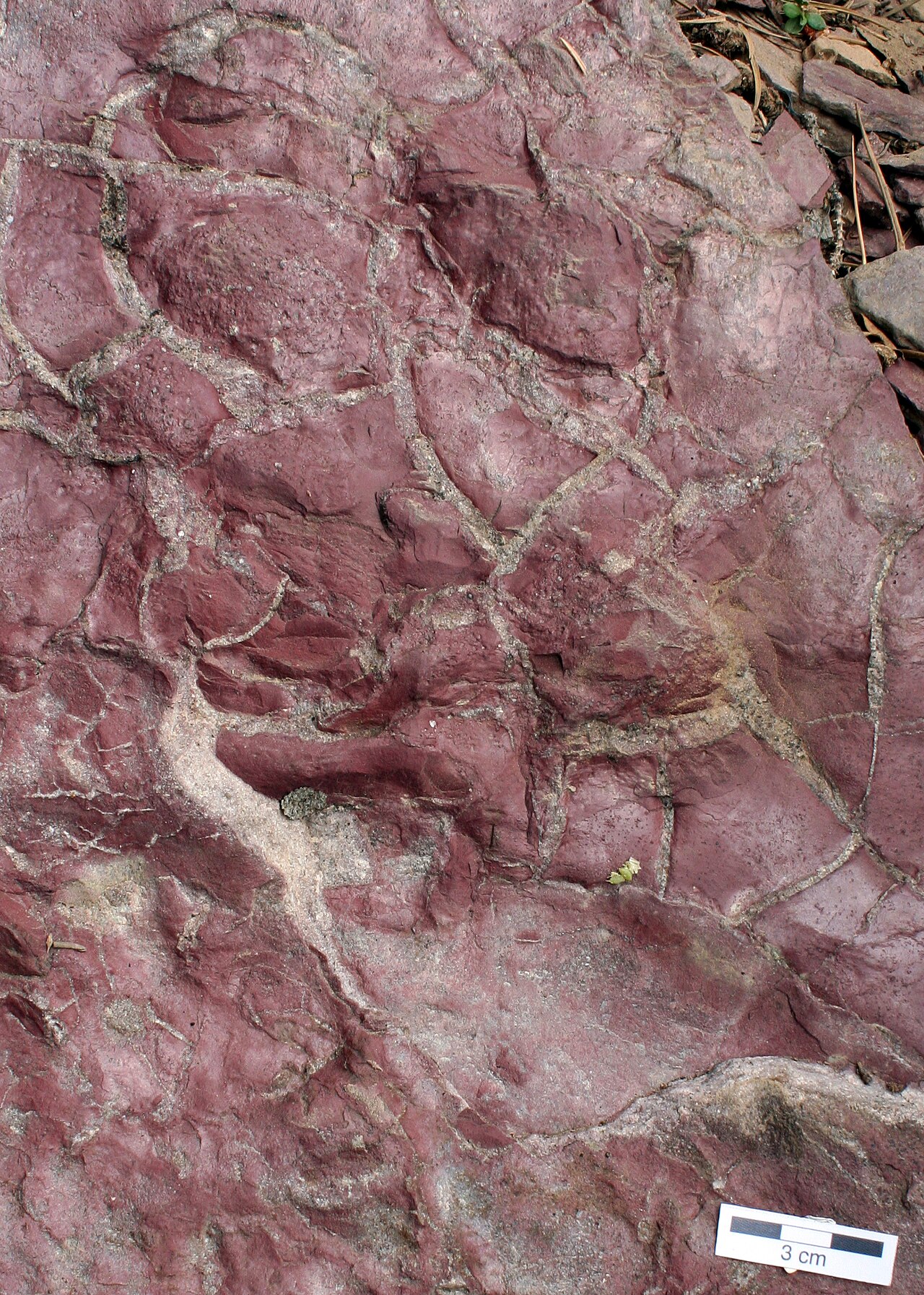
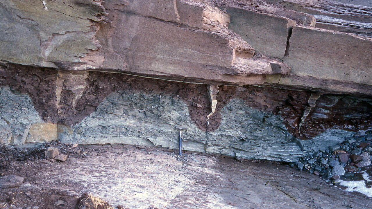
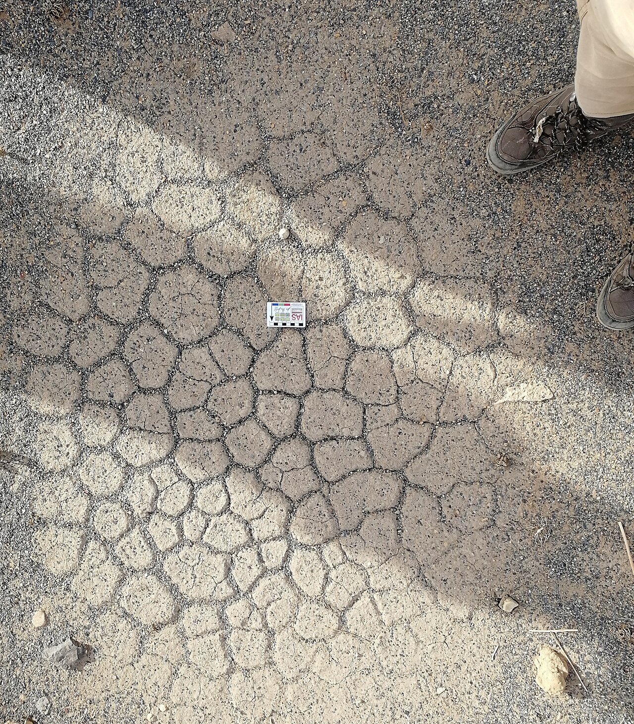
The process begins with wet, muddy sediment that contracts as it dries. Because the top layer shrinks while the material underneath stays the same size, strain builds up. Once that strain is large enough, channel cracks form on the dried surface to relieve it. These cracks spread and link together, creating a polygonal, interconnected network known as tessellations. If strain continues, the polygons curl upward at their edges—a feature geologists use to figure out the original orientation of a rock layer. Later, sediment can fill the cracks, forming casts on the base of the overlying bed.
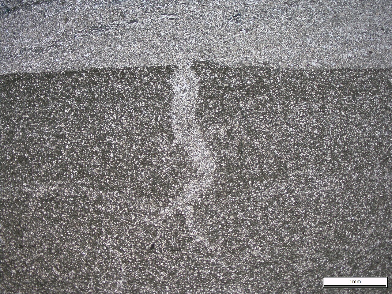
Initially, crack patterns are dominated by T-shaped junctions. But if a mudfield is repeatedly wetted and dried, the pattern can anneal into Y-shaped junctions, which are thermodynamically more stable—similar to what happens in columnar jointing and polygonal patterned ground. A related but different feature, syneresis cracks, forms underwater when muddy sediment shrinks due to changes in salinity or chemistry, not from exposure to air. Syneresis cracks tend to be discontinuous, sinuous, and trilete or spindle-shaped, which distinguishes them from true mudcracks.
Seen from above, mudcracks are generally polygonal; in cross-section, they are V-shaped, with the opening at the top of the bed and the crack tapering downward. In 1982, Allen proposed a classification scheme based on completeness, orientation, shape, and type of infill.
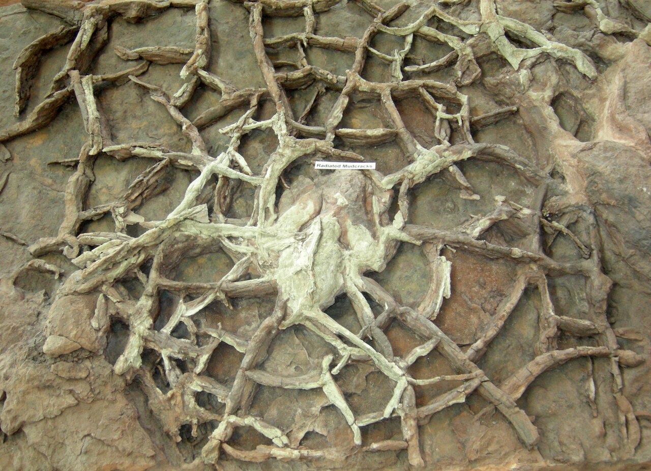
Complete mudcracks form an interconnected tessellating network, often when individual cracks join into larger continuous ones. Incomplete mudcracks are not connected to each other, though they occur in the same area.
In plan view, orthogonal intersections can be either oriented or random. Oriented orthogonal cracks are usually complete and bond together into irregular polygons, sometimes forming rows. Random orthogonal cracks are incomplete and unoriented, so they don’t connect or make general shapes—though they aren’t perfectly geometric either. Non-orthogonal mudcracks have geometric patterns.
- Type
- Sedimentary structure
- Formation
- Drying and contraction of muddy sediment
- Common shapes
- Polygonal (from above), V-shaped (in cross section)
- Key feature
- Cracks taper downward, V opens toward top of bed
- Preservation
- As v-shaped cracks on top of bed or as casts on base of overlying bed
- Environments
- Abandoned river channels, floodplain muds, dried ponds
Lore & Background
Mudcracks start as wet, muddy sediment dries and contracts, creating strain because the top layer shrinks while underlying material remains unchanged. When strain becomes sufficient, channel cracks form on the surface, spreading and joining into polygonal networks called tesselations. Continued strain causes polygons to curl upward, a feature used to interpret original rock orientation. Initial crack patterns typically show T-shaped junctions, but repeated wetting and drying can anneal them to Y-shaped junctions, which are thermodynamically favored.
Reader's Guide
Mudcracks are valuable to geologists for interpreting ancient environments and rock orientation. Their morphology—polygonal from above and V-shaped in cross section—allows identification of top and bottom in deformed rock sequences. The presence of mudcracks indicates subaerial exposure and drying, distinguishing them from syneresis cracks, which form underwater due to salinity or chemical changes. Preservation occurs either as cracks on the top of a bed or as casts on the base of an overlying bed, the latter helping determine vertical orientation in folded or faulted rocks. Mudcracks also form in human-made materials like ceramic glazes, paint film, and poorly made concrete, and can be studied at small scales using thin films in micro- and nanotechnologies.
Did You Know?
- Mudcracks are typically polygonal when seen from above and V-shaped in cross section, with the V opening toward the top of the bed.
- Repeated wetting and drying can anneal initial T-shaped crack junctions to Y-shaped junctions, which are thermodynamically favored.
- Mud curls form during final desiccation stages and, if transported by currents, may be preserved as mud-chip rip-up clasts.
- Syneresis cracks are similar but form underwater from salinity or chemical changes, and are distinguished by being discontinuous, sinuous, and trilete or spindle-shaped.
Formation & the Physics of Cooling
When magma or lava solidifies into igneous rock such as basalt, substantial residual heat remains trapped within the newly formed solid. As the rock continues to cool, it contracts and generates fractures to relieve the resulting tensile stress, a process further accelerated by groundwater boiling and reflux. At the surface, the earliest cracks propagate as T-junctions—resembling ordinary mudcracks—because each fracture advances independently until it collides with a pre-existing one. These cracks then extend downward in a roughly planar front parallel to the surface. As the front migrates, the crack network anneals toward a lower-energy configuration. The front's velocity is governed by the local groundwater flow rate, and after penetrating a few meters the pattern settles into a hexagonal grid of roughly uniform width. That width is set by the basalt's material properties and the front speed. A dimensionless Péclet number (Pe = Lv/D, with D as thermal diffusivity) characterizes the system; across all columnar jointing Pe hovers near 0.2, meaning scaled shapes and speeds are remarkably consistent. Basalt yields Pe ≈ 0.35, while a cornstarch analog gives Pe ≈ 0.1. Drying a centimeter-thick layer of cornstarch produces columns roughly 1 mm wide, serving as a practical scaled model.
Structure, Classification & Rock Context
The resulting columns span a vast dimensional range: diameters from a few centimeters up to 3 meters, and heights reaching as much as 30 meters. Although typically parallel and straight, individual columns may curve and vary in diameter along their length. The number of sides per column ranges from 3 to 8, with hexagonal (six-sided) columns being the most prevalent. Geologists distinguish two structural arrangements: a colonnade refers to an array of regular, straight, larger-diameter columns, while an entablature describes a more irregular, less-straight, smaller-diameter grouping. Columnar jointing is most commonly associated with igneous rocks—basalt, andesite, rhyolite, and tuff—and can appear in cooling lava flows, ashflow tuffs (ignimbrites), and certain shallow intrusions. Rarely, sedimentary rocks exhibit the phenomenon, produced by a combination of dissolution and reprecipitation of interstitial minerals (often quartz or cryptocrystalline silica) driven by hot hydrothermal fluids, coupled with thermal expansion and contraction triggered by a nearby magmatic intrusion.
Iconic Landmarks Across the Globe
Columnar jointing produces some of Earth's most striking geological landmarks. In the United States, Devils Tower in Wyoming—approximately 40 million years old and 382 meters tall—displays mostly six-sided columns, though four-, five-, and seven-sided examples also occur; geologists agree the rock solidified from an intrusion but cannot confirm whether the magma ever breached the surface. The Giant's Causeway on Northern Ireland's Antrim coast, formed by volcanic activity 60 million years ago, comprises over 40,000 columns and is linked to the legend of Finn McCool building a causeway to Scotland. In Japan, Sōunkyō Gorge in Hokkaido stretches 24 kilometers of columnar jointing originating from a Daisetsuzan eruption 30,000 years ago. Other notable sites include Fingal's Cave on Staffa, Scotland; the Deccan Traps at St. Mary's Island, India; the Garni Gorge in Armenia, dubbed the "Symphony of the Stones"; and the Stuðlagil Canyon in Iceland. Even Mars has yielded exposures of columnar jointing, imaged by the HiRISE camera aboard the Mars Reconnaissance Orbiter.
Unusual Occurrences & Broader Scientific Significance
While columnar jointing is most familiar in basaltic settings, its occurrence extends into less expected contexts. In Hong Kong's High Island Reservoir area, the columnar rocks are not mafic but felsic tuff, formed during the Cretaceous period—a reminder that the phenomenon is not exclusive to dark volcanic rocks. In the Negev desert of Israel, the HaMinsara ("Carpentry Shop") within Makhtesh Ramon showcases columnar jointed sandstone, a sedimentary occurrence. Similar sandstone columns appear in Paraguay's greater Asunción region, particularly at Cerro Kõi in Areguá and in quarries near Luque. In Australia, Sawn Rocks in Mount Kaputar National Park presents 40 meters of columnar jointing above a creek and another 30 meters below the surface. Alexander von Humboldt documented basaltic prisms in Huasca de Ocampo, Mexico, while in Malaysia's Tawau region, the Batu Bersusun feature columnar basalt along a riverbank where water cascades from the lowest point. These diverse examples underscore that columnar jointing is a broadly applicable structural phenomenon, not confined to a single rock type or tectonic setting.
Gallery
Frequently Asked Questions
What is a mudcrack in geomorphology?
A mudcrack is a sedimentary structure produced when wet, clay-rich sediment loses moisture and contracts. The shrinking upper layer generates enough internal stress to fracture the surface into an interconnected pattern.
How does the mudcrack formation process actually work?
As water evaporates from muddy sediment, the upper portion shrinks while the deeper material stays the same size, building up strain. Once that stress exceeds the material's tolerance, cracks propagate and link together into a tessellated network.
What do mudcracks look like from above versus in cross-section?
Viewed from the top, the cracks form a polygonal, interlocking pattern. In cross-section, each individual crack appears V-shaped, with the point tapering downward and the open end facing the top of the bed.
Where are mudcracks most commonly found in the field?
Geologists typically encounter them in settings where water periodically fills and then dries, such as abandoned river channels, floodplain mud deposits, and the beds of evaporated ponds.
How do mudcracks survive as a record in sedimentary rock?
They can be preserved either as the V-shaped cracks visible on the upper surface of a mudstone bed, or as three-dimensional casts on the underside of the layer deposited on top of them.
More in Geomorphology 1-24
Spotted an error? Know more?
Reader corrections go straight into our review queue. Suggest an edit · How this site is sourced