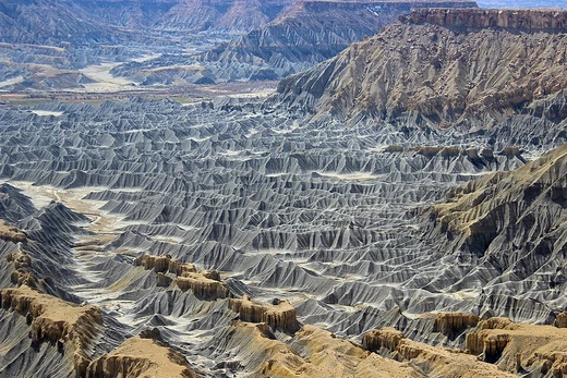
Gully
Erosional landform formed by water and mass movement.

Rihards Olups · CC BY-SA 4.0
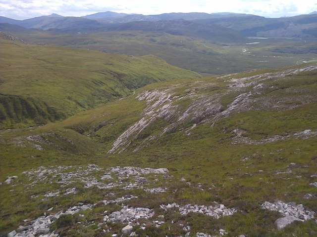
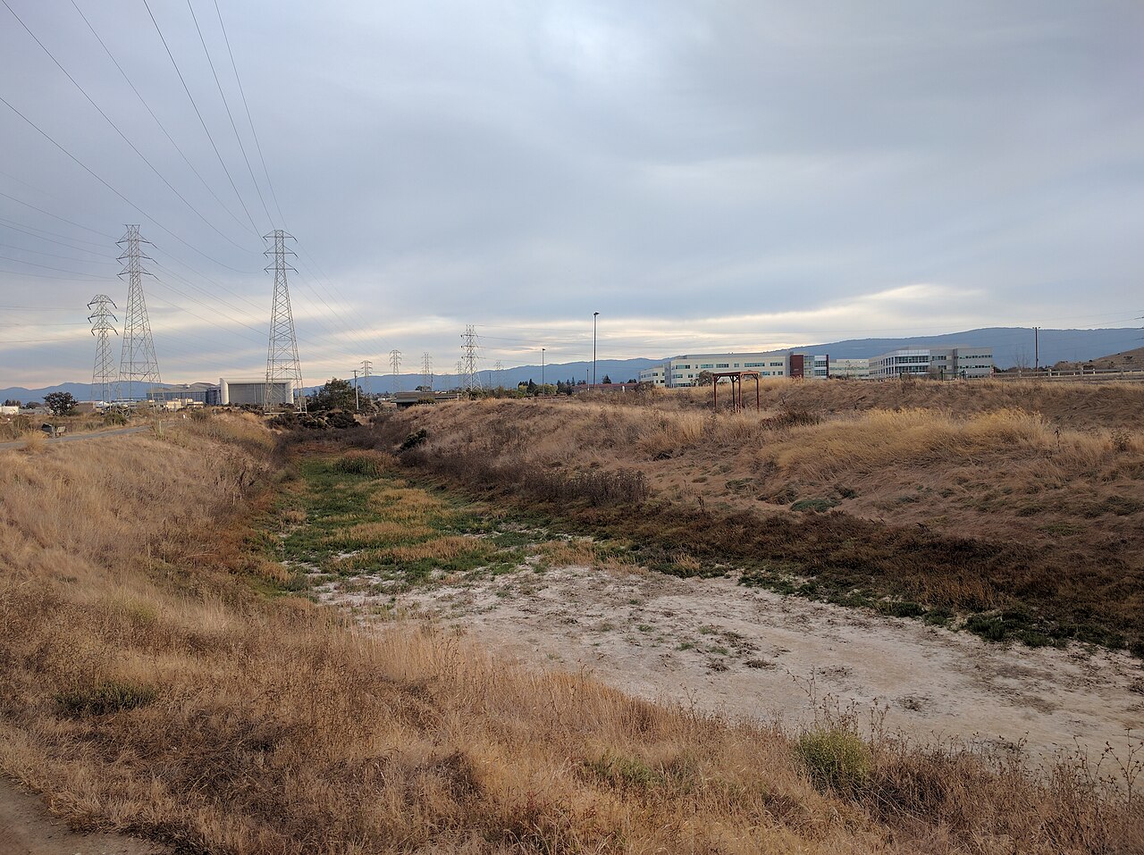
A gully is a type of landform carved into hillsides, river floodplains, or terraces by the force of running water, mass movement, or a combination of both. It erodes the soil into a steep-sided channel. Though they look like oversized ditches or narrow valleys, gullies can be several meters to tens of meters deep and wide. A key feature is a distinct headscarp (or headwall) at the upstream end, and the gully grows longer by eroding backward, against the flow of water. These formations are typically fed by temporary or seasonal water flow, often triggered by heavy, short rainstorms or melting snow.
The word "gully" first appeared in English around 1657, borrowed from the French *goulet*, a smaller version of *goule* meaning throat. It may also be linked to a type of knife called a gully-knife. Water erosion is more common on steep slopes due to the force of splashes, scour, and transport. Slope length and its proportion to the slope angle also influence erosion. In southeast Nigeria, relief and soil erosion are directly linked. Topography falls into three categories: mountains, cuesta landscapes, and plains with lowlands. Highlands with stable rock resist gullying but allow strong runoff, while uplands with soft, friable sandstone erode more easily.
Gully erosion happens through several processes: water flow cutting into the ground and eating away banks, mass movement of wet or dry wall material, groundwater seepage that undermines the surface, or the collapse of soil pipes in dispersive soils. Hillsides become more vulnerable when vegetation is removed by deforestation, overgrazing, or other activities. In rangelands, gullies often start along tracks worn by livestock or vehicles, where concentrated water flow carries away dislodged soil—especially during short, intense thunderstorms.
A gully can lengthen by headward erosion at a knickpoint, driven by surface runoff, interflow, or internal soil piping. It can also widen through mass movement on its banks and by forming tributary branches. Gullies reduce farmland productivity by cutting into the land and sending sediment downstream, choking waterways and lowering water quality in lakes and coastal areas. This is why geomorphologists and soil scientists invest heavily in studying, preventing, and rehabilitating gullied landscapes.
- Earliest known usage
- 1657
- Origin
- French word goulet, diminutive of goule (throat)
- Formation processes
- Incision, bank erosion, mass movement, groundwater seepage, soil pipe collapse
- Primary causes
- Deforestation, overgrazing, cultivation, livestock activity, vehicle tracks
- Key impact factors
- Slope (56%), rainfall (26%), land cover (12%), soil (6%)
Lore & Background
Gully erosion can progress through a variety of processes, including incision and bank erosion by water flow, mass movement of saturated or unsaturated bank material, groundwater seepage sapping overlying material, and collapse of soil pipes or tunnels in dispersive soils. Hillsides are more prone to gully erosion when cleared of vegetation through deforestation, overgrazing, or other means. In rangelands, gullies can be initiated by concentrated water flow down tracks worn by livestock or vehicles. A gully may grow in length through headward erosion at a knickpoint, resulting from interflow, soil piping, and surface runoff, and may advance laterally through mass movement acting on gully walls and the development of branches.
Reader's Guide
Gullies reduce the productivity of farmlands where they incise into the land and produce sediment that may choke downstream waterbodies and reduce water quality within drainage systems and lake or coastal systems. The total soil loss from gully formation and subsequent downstream river sedimentation can be substantial, especially from unstable soil materials prone to dispersion. Effective land management techniques can prevent gullies, including keeping vegetation along drainage lines, distributing runoff evenly, maintaining high soil organic matter, and avoiding over-cultivation. Stabilizing gullies entails altering water flow to lessen scouring, promoting sediment buildup, and revegetation using structures such as drop structures, pipe structures, grass chutes, and rock chutes. Information on gully prevention and control methods is dispersed and often lacking, especially regarding success rates and efficacy, and biophysical environment, terrain, climate, and geomorphology can lead to failure of control techniques.
Did You Know?
- The earliest known usage of the term 'gully' is from 1657, originating from the French word 'goulet', a diminutive of 'goule' meaning throat.
- Gullies can be formed artificially by hydraulic mining, where jets of water are projected onto soft alluvial deposits to extract gold or tin ore.
- In a study in Zaria, Kaduna state, Nigeria, slope (56%) and rainfall (26%) were found to have the biggest effects on gully erosion.
Anatomy of a Gully
A gully is a sharply incised channel carved into the landscape by the combined forces of flowing water and gravitational mass movement. Typically found on hillsides, river floodplains, or terraces, these features resemble oversized ditches or miniature valleys, stretching from a few metres to several tens of metres in both depth and width. A defining structural element is the headscarp, or headwall, a steep face at the upstream end where the gully actively retreats. This headward erosion—driven by surface runoff, interflow, and internal soil piping—allows the channel to lengthen over time, while lateral processes such as bank collapse and mass movement widen it and spawn tributary branches. Gullies are most closely tied to intermittent or ephemeral water flow, often triggered by short, intense thunderstorms or prolonged rainfall and snowmelt events. The initial stage is a rill, a shallow channel of displaced soil; left unattended, a rill deepens and broadens until it qualifies as a full gully.
Consequences for Land and Livelihood
When a gully cuts through agricultural terrain, the consequences cascade far beyond the channel itself. Farmland productivity drops sharply as fertile topsoil is stripped away, reducing crop yields and, in severe cases, contributing to food shortages. The displaced sediment travels downstream, choking rivers, streams, and lakes while discoloring water supplies and creating breeding grounds for rodents. Property boundaries can be literally split, arable land lost, and amenity values diminished. Infrastructure such as homes, power poles, and water pipelines may be undermined and destroyed. The organic content of the soil diminishes, undermining plant viability for seasons to come. In southeast Nigeria, research in Zaria, Kaduna State, identified slope as the dominant driver of gully erosion at 56 percent, followed by rainfall at 26 percent, land cover at 12 percent, and soil type at 6 percent. The broader ecological cost includes the encroachment of eroded zones into natural forests and the contamination of surrounding ecosystems by washed-away field materials.
Fighting the Gully: Prevention and Stabilization
Preventing gully formation relies on a suite of land-management practices that keep the soil anchored and water distributed. Core strategies include maintaining vegetation along drainage lines, classifying those lines as distinct land classes, distributing runoff evenly across the landscape, preserving soil organic matter, and avoiding over-cultivation. Vegetation barriers and plant residues can slow erosion, though their effectiveness is limited. Where a gully already exists, stabilization work focuses on redirecting water flow to reduce scouring and sediment buildup, then encouraging revegetation. Engineers deploy drop structures, pipe structures, grass chutes, and rock chutes to move water safely from the natural channel level down to the gully floor, with additional structural modifications needed along particularly steep sections. Despite these tools, reliable information on success rates and long-term efficacy remains scattered and incomplete. The biophysical environment, local terrain, climate, and geomorphology all influence runoff patterns and sediment behavior, meaning that a technique effective in one setting may fail in another, and gully stability is never guaranteed.
Origins of the Name and Geographic Vulnerability
The word "gully" first appears in the English record in 1657, borrowed from the French goulet, itself a diminutive of goule, meaning throat. Some scholars link the term to a type of knife called a gully-knife in use at the time. Geographically, gullies are not evenly distributed; their likelihood is shaped by slope, lithology, and land use. Steep terrain is inherently more vulnerable because of greater erosive pressures, splash, scour, and transport capacity. In southeast Nigeria, relief and soil erosion show a positive correlation. Highlands built on stable rock may shed vigorous runoff yet resist gullying, whereas uplands underlain by friable sandstones are far more susceptible. Human activity amplifies the risk: cultivation on even gentle hillslopes in farmland can initiate or accelerate gully formation, while in rangelands the removal of vegetative cover combined with livestock trampling and vehicle tracks concentrates water flow along worn paths, turning natural erosion features into rapidly deepening channels.
Gallery

Frequently Asked Questions
What exactly is a gully in geomorphology?
A gully is a steep-sided erosional channel carved into hillsides, floodplains, or terraces by running water, mass movement, or both. Unlike a simple ditch, it can reach depths and widths of several to tens of meters and is fed mainly by temporary or seasonal flows such as intense rainstorms or snowmelt.
How does a gully actually form and keep growing?
The primary mechanisms include incision into the channel floor, lateral bank erosion, mass movement of soil, groundwater seepage, and collapse of soil pipes. Once established, the gully lengthens by headward erosion—its upstream headscarp retreats against the direction of water flow, extending the channel over time.
What human activities make gullies worse?
Deforestation, overgrazing, intensive cultivation, livestock trampling, and vehicle tracks all destabilize the soil and accelerate gully development. In terms of natural impact factors, slope angle is the single largest driver (about 56 % of variance), followed by rainfall intensity (26 %), land-cover type (12 %), and soil properties (6 %).
What is a headscarp and why do geomorphologists care about it?
The headscarp (or headwall) is the steep, often near-vertical face at the upstream end of a gully where active back-erosion is occurring. It is the key diagnostic feature that distinguishes a true gully from a simple rill or ditch, and its retreat rate is a primary measure of how fast the landform is extending.
Where does the word 'gully' come from?
The term traces back to the French word *goulet*, itself a diminutive of *goule* meaning 'throat,' evoking the narrow, constricted shape of the channel. Its earliest recorded English usage dates to 1657.
More in Geomorphology 1-24
Spotted an error? Know more?
Reader corrections go straight into our review queue. Suggest an edit · How this site is sourced