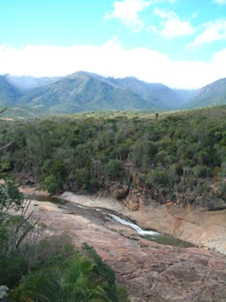
Protected areas of Madagascar
Madagascar's protected areas network expanded under the 2003 Durban Vision.

Hariniaina14 · CC0
The protected areas of Madagascar include all officially recognized protected areas as of 2015. The network is managed by Madagascar National Parks (MNP, formerly ANGAP) and comprises three original types: Strict Nature Reserves (IUCN category Ia), National Parks (IUCN category II), and Wildlife Reserves (IUCN category IV). In 2003, President Marc Ravalomanana announced the Durban Vision, an initiative to expand protected areas from approximately 17,000 km² to over 60,000 km², representing an increase from 3% to 10% of Madagascar's area. This vision led to legislation allowing four new categories of protected areas and enabling entities beyond MNP to manage them.
- Managing body
- Madagascar National Parks (MNP, formerly ANGAP)
Lore & Background
The protection of natural sites in Madagascar began in 1927 under French colonial authority, with sites reserved for scientific research and closed to the public. The Association Nationale pour la Gestion des Aires Protégées (ANGAP) was established in 1990 as the first government agency dedicated to expanding and managing protected areas. The creation of a national park system accelerated in the 1990s and was formally codified with the establishment of the Système des Aires Protégées de Madagascar (SAPM) under the 2003 Code des Aires Protégées.
Reader's Guide
The protected areas of Madagascar represent a significant conservation effort, particularly following the 2003 Durban Vision announced by President Marc Ravalomanana. This initiative aimed to more than triple the area under protection, from about 17,000 km² to over 60,000 km², covering 10% of the country. The vision broadened the definition of protected areas, adding four new IUCN categories and allowing management by government ministries, community associations, NGOs, and the private sector. The network includes two UNESCO World Heritage Sites: Tsingy de Bemaraha National Park (1999) and the Rainforests of the Atsinanana (2007), the latter placed on the World Heritage in Danger list in 2010 due to increased illegal logging following the 2009 political crisis. The system's legal framework faced delays after the 2009 crisis, but the network remains a cornerstone of Madagascar's biodiversity conservation.
Did You Know?
- The first protected natural sites in Madagascar were established in 1927 under French colonial authority and were reserved for scientific research, not open to the public.
- UNESCO placed the Rainforests of the Atsinanana on the list of World Heritage in Danger on 30 July 2010, following increased illegal logging after the 2009 political crisis.
Colonial Origins and the Path to a National System
The story of Madagascar's protected areas stretches back to 1927, when French colonial authorities first set aside natural sites specifically for scientific research purposes, keeping them closed to general public access. This early framework was purely academic in character, with no public engagement component. A significant shift arrived in 1971, when the Malagasy government launched a project to safeguard roughly 3,000 square kilometers of mangrove forests, marking the nation's first deliberate effort to protect its marine ecosystems. In 1986, with backing from the IUCN and the World Wildlife Fund, the government embarked on a twelve-year assessment of existing and potential protected areas to identify conservation priorities. This groundwork culminated in 1990 with the founding of ANGAP, the first dedicated government agency tasked with expanding and managing the country's protected areas network. The national park system itself took shape in 1991 through landmark environmental policies, progressing through three distinct phases before the SAPM framework was finalized in 2002.
The Durban Vision and a Leap in Ambition
On September 17, 2003, at the IUCN World Parks Congress held in Durban, Malagasy President Marc Ravalomanana made a landmark announcement: Madagascar would more than triple its protected area coverage from approximately 17,000 square kilometers to over 60,000 square kilometers, raising the proportion of the island under protection from three percent to ten percent within five years. This ambitious pledge, widely referred to as the Durban Vision, required a fundamental rethinking of what counted as a protected area. New legislation was enacted to recognize four additional IUCN categories—Natural Parks, Natural Monuments, Protected Landscapes, and Natural Resource Reserves—broadening the scope of conservation objectives considerably. Equally transformative, the revised legal framework opened the door for management beyond the traditional PNM-ANGAP structure, permitting government ministries, community associations, NGOs, civil society groups, and private-sector entities to take on stewardship roles. By 2003, an additional 92 areas had been identified as deserving protected status, though some remained pending formal review.
Institutional Architecture and Shared Stewardship
The institutional architecture governing Madagascar's protected areas evolved through a deliberate, multi-stakeholder process. The SAPM commission was established to coordinate the national system, working alongside the Ministry of Environment, Water and Forests and the Ministry of Agriculture, Livestock and Fishery. The World Wildlife Fund serves as co-president of this commission, supporting the government in park management while simultaneously cultivating partnerships with local communities, civil society organizations, and the private sector. In March 2005, following intensive collaboration with the IUCN and a range of international and local experts, the government formalized the current classification and legal protection framework. The network, managed by PNM-ANGAP, encompasses three core IUCN categories: Strict Nature Reserves (Ia), National Parks (II), and Wildlife Reserves (IV). However, the political crisis of 2009 stalled the legislative updates needed to secure the legal status of all areas added under the Durban Vision commitment, leaving portions of the expanded network in a state of incomplete formal protection.
World Heritage Glory and the Shadow of Crisis
Madagascar's protected areas have earned significant international recognition through UNESCO World Heritage designations. In 1999, Tsingy de Bemaraha National Park became the first Malagasy site to receive this distinction. Eight years later, in 2007, six additional national parks—Marojejy, Masoala, Ranomafana, Zahamena, Andohahela, and Andringitra—were collectively inscribed as a joint World Heritage Site under the title Rainforests of the Atsinanana. However, this prestige came under serious threat when the political crisis of 2009 triggered a surge in illegal logging across the parks. In response, UNESCO placed the Rainforests of the Atsinanana on its World Heritage in Danger list on July 30, 2010, citing the escalating destruction of forest cover. This designation underscored the vulnerability of even internationally recognized conservation sites when political instability undermines law enforcement and governance, highlighting the precarious balance between global recognition and on-the-ground protection in Madagascar.
Gallery
Frequently Asked Questions
Who manages the protected areas of Madagascar?
Madagascar National Parks (MNP), which previously operated under the name ANGAP, is the body responsible for overseeing the entire protected areas network across the island.
What are the original categories of protected areas in Madagascar?
The network was built around three foundational types: Strict Nature Reserves (IUCN Ia), National Parks (IUCN II), and Wildlife Reserves (IUCN IV). Additional categories were later added through new legislation following the Durban Vision.
What is the Durban Vision?
Announced by President Marc Ravalomanana in 2003, the Durban Vision was a national initiative to dramatically grow Madagascar's protected-area coverage. It set a target of raising the share of protected land from roughly 3% to 10% of the island's total area.
How much land does Madagascar's protected areas network cover?
Before the 2003 expansion drive, the network spanned approximately 17,000 square kilometers. The Durban Vision aimed to push that figure past 60,000 square kilometers.
Why is Madagascar's protected areas network important?
Madagascar harbors an extraordinary concentration of species found nowhere else on Earth, making its protected areas critical for preserving that unique biodiversity. The network serves as the backbone of the country's conservation strategy.
More in National parks of Madagascar 1-24
Spotted an error? Know more?
Reader corrections go straight into our review queue. Suggest an edit · How this site is sourced