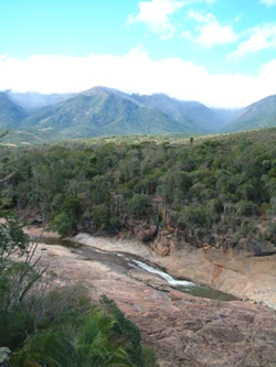
Andohahela National Park
Park with rainforest, spiny forest, and transitional forest zones.

Hiroki Ogawa · CC BY 3.0
Andohahela National Park is a protected area in the Anosy region of south-eastern Madagascar. It is notable for containing extreme contrasts of habitat, including the last humid rainforests in the southern part of the country, as well as dry spiny forest and transitional forest.
Quick Facts
- Iucn Category
- II
- Location
- Anosy, Madagascar
- Nearest City
- Tôlanaro (Fort Dauphin)
- Area
- 760 km / 2
- Established
- 1939 (protected area) / 1998 (national park)
- Visitation Num
- approx. 1300
- Visitation Year
- 2005
- Governing Body
- Madagascar National Parks Association
Facts from the source article.
Lore & Background
Andohahela National Park lies 40 kilometres north-west of Fort-Dauphin, at the southern end of the Malagasy Highlands. It is divided into three zones: Malio, which contains dense lowland and montane rainforest with over two hundred species of tree ferns, orchids, and wild vanilla; Ihazofotsy-Mangatsiaka, which features dry spiny forest; and Tsimelahy, which holds the unique Ranopiso transitional forest. The mountains create a natural barrier to moist trade winds, producing a stark rainfall gradient—1,500–2,000 mm per year on the eastern side and only 600–700 mm on the western edge.
Reader's Guide
Andohahela National Park is significant as a World Heritage Site inscribed in 2007 as part of the Rainforests of the Atsinanana. Its importance lies in its remarkable habitat diversity, which supports a high richness of species. The park is the richest place in Madagascar for lemurs, with fifteen species recorded, including the ring-tailed lemur and Verreaux's sifaka. It also hosts 67 reptile species, 130 bird species, 50 amphibian species, and the endemic Triangle palm. The park is accessible via the unpaved Provincial road RIP118 from Soanierana, and several circuits within each habitat type can be reached by road from Fort-Dauphin.
Did You Know?
- Andohahela National Park contains the last humid rainforests in southern Madagascar.
- The park is divided into three distinct zones: Malio, Ihazofotsy-Mangatsiaka, and Tsimelahy.
- Fifteen species of lemurs have been recorded in the park, including ring-tailed lemur and Verreaux's sifaka.
- The Triangle palm (Dypsis decaryi) is found in several locations in southeastern Madagascar, not exclusively in Andohahela National Park.
A Landscape of Contrasting Extremes
Andohahela National Park occupies 760 square kilometres of the Anosy mountain range, the southernmost extension of the Malagasy Highlands. What makes this park extraordinary is the sheer range of environments packed into a single protected area. The park is divided into three distinct zones. The Malio zone sweeps from 100 metres up to the 1,956-metre summit of Pic d'Andohahela, hosting dense lowland and montane rainforest. The Ihazofotsy-Mangatsiaka zone, rising to 1,005 metres at Pic de Vohidagoro, is dominated by dry spiny forest. The third zone, Tsimelahy, sits at roughly 125 metres and shelters the unique Ranopiso transitional forest. The mountains themselves act as a natural barrier to moist trade winds arriving from the east. On the eastern face, annual rainfall reaches 1,500 to 2,000 millimetres, sustaining one of the few rainforests south of the Tropic of Capricorn. Just a short distance to the west, precipitation drops to 600 to 700 millimetres, giving rise to the arid spiny vegetation typical of southern Madagascar.
A Living Treasury of Species
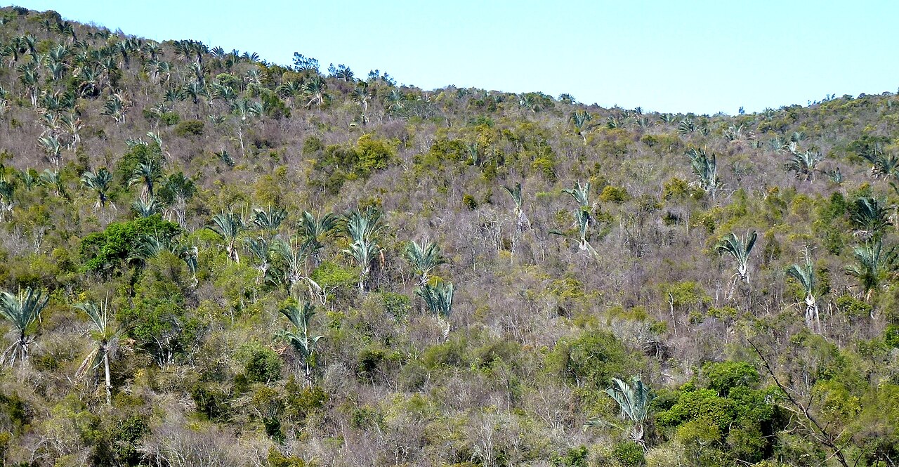
The ecological diversity of Andohahela is matched by an extraordinary concentration of animal and plant life. The park is the richest site in all of Madagascar for lemurs, with fifteen species documented within its boundaries. Among them are two of the island's most iconic primates: the ring-tailed lemur and Verreaux's sifaka. Beyond primates, the park shelters 67 species of reptiles, including rare geckos, turtles, and snakes, alongside 130 bird species and fifty amphibians. The Malio zone alone supports more than two hundred species of tree ferns, orchids, and wild vanilla. Perhaps most strikingly, the Triangle palm is found nowhere else on Earth except within Andohahela's borders. The dry spiny forest of the Ihazofotsy-Mangatsiaka zone harbours its own assemblage of rare birds and reptiles, while the transitional Ranopiso forest of Tsimelahy represents a habitat type found in only a handful of locations. Together, these zones create a biological mosaic unmatched in the southern half of the island.
From Protected Land to World Heritage
The story of Andohahela's conservation spans nearly nine decades. The area first received protected status in 1939, making it one of the earliest conservation designations in Madagascar. However, it was not until 1998 that the region was formally elevated to national park status, a full fifty-nine years after its initial protection. This long journey from a modest reserve to a fully designated national park reflects the evolving priorities of Malagasy environmental policy. The culmination of this trajectory came in 2007, when Andohahela was inscribed on the UNESCO World Heritage List as part of the broader Rainforests of the Atsinanana site. This designation recognised the park's role in preserving the last humid rainforests in the southern part of Madagascar, ecosystems that have been vanishing across the island for decades. The World Heritage listing placed Andohahela among a select group of sites considered to hold outstanding universal value, underscoring the irreplaceable nature of the habitats and species found within its 760 square kilometres.
Reaching the Southern Highlands
Andohahela National Park sits approximately 40 kilometres north-west of Fort-Dauphin, a town that serves as the practical gateway for visitors. The park occupies the southernmost spur of the Malagasy Highlands in the Anosy region of south-eastern Madagascar. Access to the park is via the unpaved Provincial Road RIP118, which begins in the town of Soanierana. Travellers should anticipate a rough journey, as the road remains entirely unpaved, making the approach a test of patience and vehicle capability. Despite the challenging access, several circuits within each of the park's habitat types can be reached by road from Fort-Dauphin, offering structured opportunities to experience the Malio rainforest, the Ihazofotsy-Mangatsiaka spiny forest, and the Tsimelahy transitional woodland. The park's position at the southern terminus of the highlands gives it a unique geographical character, separating the wet eastern slopes from the arid western landscapes and creating a natural laboratory of ecological transition.
Gallery

Frequently Asked Questions
Where is Andohahela National Park located?
It sits in the Anosy region of south-eastern Madagascar, covering roughly 760 square kilometres of protected land.
What makes Andohahela's ecosystems so unusual?
The park is famous for packing extreme habitat contrasts into a single area, from the last remaining humid rainforests in southern Madagascar to dry spiny forest and transitional woodland.
When did Andohahela become a national park?
The area first received protected status back in 1939, but it was only formally designated as a national park in 1998.
What is the highest point in Andohahela National Park?
The terrain ranges from about 100 metres up to 1,956 metres at Pic d'Andohahela, giving the park one of the most dramatic elevation spans in the region.
Why was Andohahela added to the UNESCO World Heritage list?
In 2007 it was inscribed as part of the broader 'Rainforests of the Atsinanana' site, recognised for safeguarding Madagascar's irreplaceable forest biodiversity.
More in National parks of Madagascar 1-24
Spotted an error? Know more?
Reader corrections go straight into our review queue. Suggest an edit · How this site is sourced