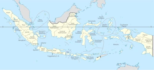
Riau Islands
Indonesian province of islands with rich maritime history.

Twotwofourtysix · CC BY-SA 4.0
The Riau Islands (Indonesian: Kepulauan Riau) is a province of Indonesia consisting of a group of islands located in the western part of the country. Established in 2002 after being separated from Riau Province, its capital is Tanjung Pinang and its largest city is Batam. The province has played a significant role in the maritime history and civilization of the Nusantara region, influenced by the Srivijaya Empire between the 7th and 13th centuries and later by the Johor Sultanate.
Quick Facts
- Settlement Type
- Province
- Shield Link
- Armorial of Indonesia#Provincial
- Shield Size
- 80
- Established Title
- Established
- Established Date
- 24 September 2002
- Seat Type
- Capital
- Seat
- Tanjungpinang
- Parts Type
- Divisions
Facts from the source article.
Lore & Background
The Riau Islands have been home to Malay and Orang Laut people for centuries, with later migrants from southern China and Indochina. The archipelago lies on the China–India maritime trading route, and Chinese records indicate that Bintan and Temasek (old Singapore) were inhabited by Malay corsairs. Between the 7th and 13th centuries, the area was under the influence of the Srivijaya Empire, evidenced by the Pasir Panjang Inscription in Karimun Regency, which shows a single footprint of Buddha (or a Buddhist figure) accompanied by a mantra. After Srivijaya's decline, the islands became part of the Bentan Kingdom, though historical records of its early rulers remain unclear; the figure Raja Iskandar Syah is traditionally associated with the 15th-century Malacca Sultanate rather than the Bentan Kingdom around 1100 AD.
Reader's Guide
The Riau Islands' significance lies in their strategic location on one of the world's busiest shipping lanes along the Malacca Strait and the Natuna Sea. They have been a center of Malay culture and Islamic studies, particularly after the fall of Malacca in 1511, when the Johor Sultanate based on Bintan became a political and cultural hub. The Anglo-Dutch Treaty of 1824 partitioned the region, placing the Riau-Lingga Sultanate under Dutch influence. In the modern era, the islands are part of the Indonesia–Malaysia–Singapore Growth Triangle, experiencing rapid industrialization since the 1970s. The province is one of Indonesia's most prosperous, with the fourth-highest GDP per capita and Human Development Index. Its population is highly diverse, including Malays, Chinese, Javanese, and expatriates, and it attracts the second-largest number of foreign tourists in Indonesia after Bali.
Did You Know?
- The Riau Islands were established as a province in September 2002, making it one of Indonesia's youngest provinces at the time, though later provinces such as North Kalimantan have since been created.
- The Pasir Panjang Inscription in Karimun Regency features a single footprint of Buddha (or a Buddhist figure) with a mantra, indicating early Buddhist practices before Islam.
- The name 'riau' may derive from the Portuguese word 'rio' (river), the Malay word 'riuh' (crowded), or the word 'riahi' (sea water).
- The province has the second largest number of foreign tourist arrivals in Indonesia, after Bali.
Geography & Strategic Position
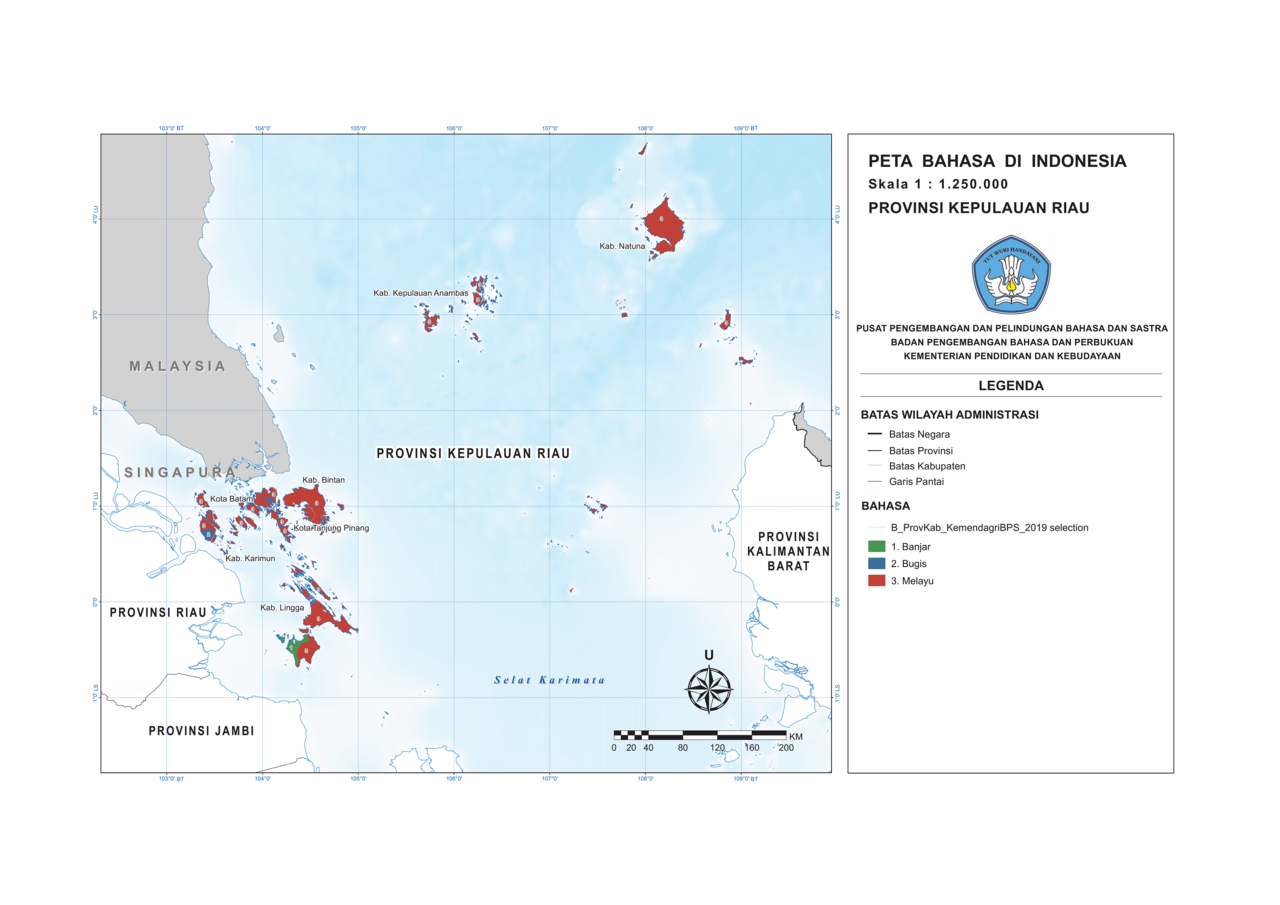
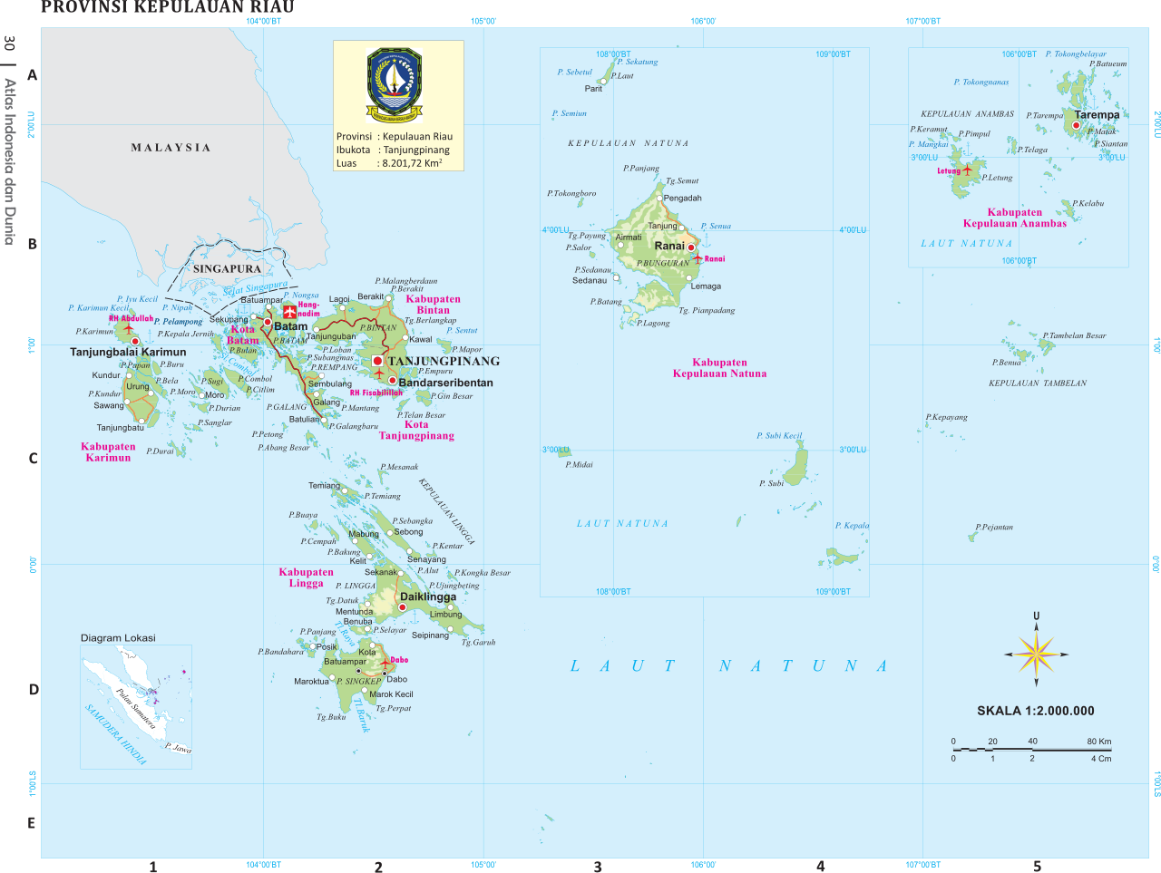
The Riau Islands stretch across a vast expanse of the western Indonesian archipelago, comprising 2,408 islands—1,798 of which carry official names—scattered between the landmasses of Sumatra, the Malay Peninsula, and Borneo. With a combined land area of roughly 8,709 square kilometres, the province includes the well-known Riau Archipelago and sits astride two of the world's busiest maritime corridors: the Malacca Strait and the Natuna Sea, the latter forming part of the broader South China Sea. This positioning grants the province water borders with Singapore, Malaysia, and Brunei, while its maritime neighbors to the west, south, and east include Riau, Jambi, Bangka Belitung Islands, West Kalimantan, Vietnam, and Cambodia. Tanjung Pinang serves as the provincial capital, though Batam has grown into the largest urban center. Beyond its strategic shipping location, the islands hold significant mineral and energy deposits alongside rich marine resources, making the region a focal point for both trade and resource development.
Maritime History & Ancient Civilizations
Long before modern nation-states drew their borders, the Riau archipelago was a crucible of maritime power. From the seventh through the thirteenth centuries, the region fell within the sphere of the mighty Srivijaya Empire, which dominated trade along the Malacca Strait. The Pasir Panjang Inscription, unearthed in Karimun Regency, bears witness to early Buddhist practice—depicting the footprints of the Buddha—and confirms settled communities and the spread of the faith well before Islam reached these shores. In 1290, Sri Tri Buana of the Palembang royal house sailed a flotilla of eight hundred vessels to Bintan, where he was received by the island's queen. The archipelago's waters were also notorious for piracy; Chinese records describe as many as three hundred warships used to intercept vessels returning from the Indian Ocean. Large hoards of Song-dynasty ceramics recovered on Bintan attest to centuries of contact. The 13th-century traveler Ibn Battuta recorded armed Malay pirates launching from these small islands, and even today Bintan retains the colloquial nickname "Pirate Island."
Colonial Legacy & Political Formation
The political identity of the Riau Islands was shaped by centuries of shifting sovereignty. After the decline of Srivijaya, the region came under the Bentan Kingdom around 1100 AD, with Raja Iskandar Syah among its most notable rulers. It later became part of the Johor Sultanate, but the Anglo-Dutch Treaty of 1824 redrew the map: the Johor-Pahang sultanates fell under British influence, while the Riau-Lingga sultanates became a Dutch protectorate. That protectorate lasted until 1911, after which the Dutch East Indies administered the archipelago directly. The Japanese occupation of 1942–1945, followed by the Indonesian National Revolution of 1945–1949, ultimately brought the islands into the newly independent Republic of Indonesia. For decades they remained part of the larger Riau Province, until September 2002, when they were carved out as a separate province—making the Riau Islands Indonesia's third-youngest. The very name "Riau" carries layered etymologies: possibly from the Portuguese "rio" (river), the Arabic-influenced "riahi" (sea water), or the Malay "riuh" (crowded, bustling), each reflecting a different chapter of the region's long story.
Economic Prosperity & Cultural Mosaic
Since the 1970s, the Riau Islands have undergone rapid industrialization, buoyed by their status as a free trade zone within the Indonesia–Malaysia–Singapore Growth Triangle. By 2011, the province's GDP per capita reached approximately 72.6 million rupiah (around 8,300 US dollars), ranking fourth among all Indonesian provinces behind East Kalimantan, Jakarta, and Riau. Its 2018 Human Development Index of 0.748 likewise placed it fourth nationally, trailing only Jakarta, the Special Region of Yogyakarta, and East Kalimantan. This economic magnetism has drawn a remarkably heterogeneous population: indigenous Malays, Chinese, Javanese, Minangkabau, and many others coexist alongside waves of immigrants and workers lured by the region's growth. The Batam area in particular hosts a large expatriate community, roughly eighty percent of whom come from other parts of Asia, with the remaining western residents hailing from the United Kingdom, continental Europe, Australia, and the United States. The province also records the second-highest number of foreign tourist arrivals in all of Indonesia, surpassed only by Bali.
Gallery

Frequently Asked Questions
Who is Riau Islands?
Riau Islands is an Indonesian province comprising a scattered archipelago in the country's western seas, with Tanjung Pinang as its capital and Batam as its largest city. It gained its own provincial status in 2002 after being split off from the broader Riau Province.
What is Riau Islands's role?
The province has long served as a maritime crossroads, first shaped by the Srivijaya Empire in the 7th through 13th centuries and later by the Johor Sultanate. In the modern era it functions as a strategic island province within Indonesia's Nusantara maritime sphere.
Why is Riau Islands important?
Its position in the western Indonesian seas gives it outsized cultural and economic weight, with a 2011 per-capita GDP of about Rp 72.6 million (around US$8,300). Centuries of Srivijaya and Johor-era civilisation also make the archipelago a key chapter in Nusantara's broader maritime heritage.
When and how was Riau Islands established?
The province came into existence in 2002 when it was formally separated from the existing Riau Province. That administrative split gave the island group its own distinct identity and governance within Indonesia.
More in Indonesian Provinces 1-19
Spotted an error? Know more?
Reader corrections go straight into our review queue. Suggest an edit · How this site is sourced