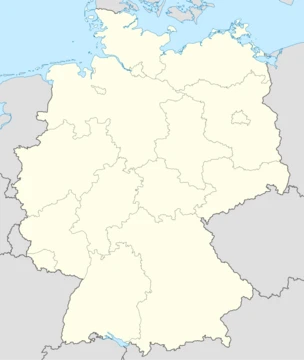
Lower Saxony
Fourth-largest German state by area, with diverse landscapes from coast to mountains

Lower Saxony is a northwestern German state that borders the North Sea. It ranks as Germany’s fourth-largest state by area, covering 47,614 km², and its population of about 8 million (as of 2021) makes it the fourth-most populous among the country’s 16 Länder. In rural parts, some residents speak Northern Low Saxon or Saterland Frisian.
The state shares borders with the North Sea, the states of Schleswig-Holstein, Hamburg, Mecklenburg-Vorpommern, Brandenburg, Saxony-Anhalt, Thuringia, Hesse, and North Rhine-Westphalia, as well as the Netherlands. This gives Lower Saxony more neighbors than any other German state. The state of Bremen exists as two enclaves within Lower Saxony: the city of Bremen and its seaport, Bremerhaven, which is a semi-exclave with its own coastline. The largest cities—Hanover (the capital), Braunschweig, Oldenburg, Osnabrück, Wolfsburg, Göttingen, Salzgitter, and Hildesheim—lie mostly in the central and southern parts, except for Oldenburg.
Lower Saxony boasts a diverse landscape that includes both maritime coastlines and mountainous terrain, though it is not the only Bundesland with such variety. Its northwestern coast, called East Frisia, includes the seven East Frisian Islands, a tourist destination. In the far west lies the Emsland, a sparsely populated, economically growing area once covered by inaccessible swamps. The northern half, part of the North German Plain, is mostly flat except for gentle hills around the Bremen geestland. To the south and southwest are the northern Central Uplands: the Weser Uplands and the Harz Mountains, with the Lower Saxon Hills—low ridges—between them.
In the northeast, the Lüneburg Heath is Germany’s largest heathland. During the Middle Ages, Lüneburg grew wealthy from salt mining and trade. Northward, the Elbe valley separates Lower Saxony from Hamburg, Schleswig-Holstein, Mecklenburg-Vorpommern, and Brandenburg. The left banks of the Elbe downstream from Hamburg form the Altes Land (Old Country), where a mild climate and fertile soil support the state’s largest fruit-farming area, mainly apples.
The modern state was created on 1 November 1946 from parts of the British occupation zone after World War II, merging the State of Hanover with the free states of Braunschweig, Oldenburg, and Schaumburg-Lippe. Because most of its territory came from the historic Kingdom of Hanover, Lower Saxony adopted
- Capital
- Hanover
- Area
- 47,614 km² (18,384 sq mi)
- Population (2021)
- 8 million
- Largest cities
- Hanover, Braunschweig, Oldenburg, Osnabrück, Wolfsburg, Göttingen, Salzgitter, Hildesheim
- Highest point
- Wurmberg (971 m) in the Harz
- Lowest point
- Depression near Freepsum in East Frisia (about 2.5 m below sea level)
- Borders
- North Sea, Schleswig-Holstein, Hamburg, Mecklenburg-Vorpommern, Brandenburg, Saxony-Anhalt, Thuringia, Hesse, North Rhine-Westphalia, and the Netherlands
Quick Facts
- Official Name
- Lower Saxony
- Native Name
- de · Niedersachsen / nds · Neddersassen / stq · Läichsaksen
- Settlement Type
- State
- Flag Size
- 120px
- Shield Size
- 75px
- Subdivision Type
- Country
- Subdivision Name
- Germany
- Seat Type
- Capital
- Seat
- Hanover
- Governing Body
- Landtag of Lower Saxony
- Leader Party
- SPD
- Leader Title
- Minister-President
Facts from the source article.
Lore & Background
Lower Saxony encompasses both maritime and mountainous areas, though it is not the only Bundesland to do so. Its northwestern coast on the North Sea is called East Frisia, with the seven East Frisian Islands offshore. The state's northeastern region, the Lüneburg Heath, is the largest heathland area of Germany. In the Middle Ages, the town of Lüneburg was wealthy due to salt-mining and the salt trade. The Altes Land, on the left banks of the Elbe downstream Hamburg, is the state's largest area of fruit farming, chiefly apples.
Reader's Guide
Lower Saxony's significance lies in its size, population, and geographic diversity, spanning from the North Sea coast to the Harz Mountains. It borders more neighbours than any other single Bundesland, including the enclave of Bremen. The state's economy and infrastructure are centred on cities like Hanover, Braunschweig, Wolfsburg, and Göttingen, which form the core of the Hannover–Braunschweig–Göttingen–Wolfsburg Metropolitan Region. Historically, the name derives from the Germanic Saxons, and the state adopted the coat of arms of the former Kingdom of Hanover. Its climate transitions from maritime in the northwest to continental in the southeast, with the Harz experiencing the highest precipitation. Lower Saxony is divided into 37 districts and eight urban districts, with its administrative regions dissolved in 2005.
Did You Know?
- Lower Saxony borders more neighbours than any other single Bundesland.
- The state of Bremen forms two enclaves within Lower Saxony: the city of Bremen and its seaport Bremerhaven.
- The highest point in Lower Saxony is the Wurmberg at 971 metres in the Harz.
- The Lüneburg Heath is the largest heathland area of Germany.
Geographic Duality: From Sea to Summit
Lower Saxony stands alone among Germany's sixteen states as the only one that stretches from open sea to mountain peak. Its northwestern coastline along the North Sea gives way to the East Frisian Islands, while its southeastern reaches climb into the Harz Mountains, where the Wurmberg rises to 971 metres. Between these extremes lies an extraordinary range of landscapes: the flat North German Plain, the sandy Lüneburg Heath, the rolling Lower Saxon Hills, and the Weser Uplands. The state's lowest point, a mere 2.5 metres below sea level near Freepsum in East Frisia, underscores just how dramatic this vertical span is. Rivers such as the Ems, Weser, Aller, and Elbe carve northward through the terrain, shaping settlement patterns and trade routes for centuries. This geographic breadth means that a single day's drive can take a traveller from salt-sprayed dunes to heather-covered moorland to forested upland valleys, a diversity unmatched anywhere else in the federal republic.
A Post-War Political Birth
The modern state of Lower Saxony is a product of post-war reconstruction rather than centuries of organic growth. On 1 November 1946, within the British occupation zone, the historic State of Hanover was merged with three smaller free states—Braunschweig, Oldenburg, and Schaumburg-Lippe—to form a single administrative unit. Because the bulk of the new territory had belonged to the old Kingdom of Hanover, the state adopted Hanover's coat of arms and heraldic symbols as its own identity markers. This political stitching together explains why regional loyalties remain strong in the heartlands of the former constituent states, where residents still identify more with their local tradition than with the broader state. The creation was pragmatic: a British military administration needed workable units for governance, and the result was a state whose borders reflect wartime occupation lines as much as any organic historical logic.
Soil, Salt, and Orchestras of the Land
Lower Saxony's economic story is written in its soil. In the northeast, the Lüneburg Heath—Germany's largest heathland—sits on poor, sandy geest soils, yet the medieval town of Lüneburg once grew wealthy from salt-mining and the salt trade conducted in that very landscape. Further north, the Altes Land on the left banks of the Elbe downstream of Hamburg benefits from a gentle local climate and fertile ground, making it the state's principal fruit-growing region with apples as its chief crop. In the central-east and southeast, loess-derived soils in the börde zone offer high natural fertility, supporting well-developed agriculture. The Emsland in the extreme west, once dominated by inaccessible swamps, has transformed into an economically emerging region, though it remains sparsely populated. Together, these varied agricultural zones—fruit orchards, heathland, loess farmland, and reclaimed wetlands—form a patchwork that reflects centuries of human adaptation to very different soils and microclimates.
Borders, Enclaves, and the Urban Core
No other German state touches more neighbours than Lower Saxony. Starting from the North Sea and moving clockwise, it borders eight other German states—Schleswig-Holstein, Hamburg, Mecklenburg-Vorpommern, Brandenburg, Saxony-Anhalt, Thuringia, Hesse, and North Rhine-Westphalia—plus the Netherlands, giving it more external boundaries than any other Bundesland. Adding the two enclaves of Bremen (the city itself and its semi-exclave seaport Bremerhaven, which retains its own coastline) makes the state's border situation even more complex. The Bremen/Oldenburg Metropolitan Region exists as a cooperative body to manage this enclave relationship. The state's urban and economic gravity is concentrated in its central and southern parts, where Hanover, Braunschweig, Wolfsburg, Göttingen, Salzgitter, Hildesheim, and Oldenburg anchor a metropolitan region stretching from the capital southward. With roughly eight million residents in 2021, Lower Saxony ranks fourth in population among the sixteen Länder, while its 47,614 square kilometres make it the second-largest by area.
Frequently Asked Questions
Who is Lower Saxony?
Lower Saxony is a northwestern German state that stretches from the North Sea coastline all the way up into the Harz mountains, with Hanover as its capital. It is the fourth-largest of Germany's sixteen Länder by area and home to roughly eight million residents.
What makes Lower Saxony's role distinctive among the German states?
It touches more neighboring entities than any other German state, bordering the North Sea, the Netherlands, and eight other Länder simultaneously. That gives it a uniquely central position for cross-border trade, transport links, and cultural exchange in northern Germany.
How does Lower Saxony's story end?
As a living political entity within the Federal Republic, Lower Saxony has no narrative finale—it simply continues as a functioning state with its own parliament and government. Its ongoing 'storyline' includes preserving minority languages like Saterland Frisian and balancing coastal, industrial, and rural interests.
Why is Lower Saxony important?
Its mix of North Sea coast, major industrial cities such as Wolfsburg and Braunschweig, and extensive rural heritage makes it a compact snapshot of northern German diversity. The state also anchors key cultural and economic institutions, from the Hanover trade-fair tradition to the Wadden Sea coastal landscape.
What are Lower Saxony's key geographic extremes?
Elevation ranges from a depression near Freepsum in East Frisia sitting about 2.5 meters below sea level to the Wurmberg at 971 meters in the Harz. That nearly thousand-meter spread across 47,614 square kilometers gives the state one of the most varied topographies in the country.
More in German States 1-17
Spotted an error? Know more?
This is a living reference — every entry is fact-audited, and reader corrections feed straight into our audit queue. Suggest an edit · See this site's audit record