Minamitorishima
Japan's easternmost coral atoll, rich in rare-earth deposits.

Minamitorishima—sometimes called Marcus Island, or Minami-Tori-shima—is a remote Japanese coral atoll in the northwestern Pacific Ocean. It holds the distinction of being Japan’s easternmost and most isolated territory, and it is the only Japanese landmass situated on the Pacific Plate, beyond the Japan Trench. Despite its small size—just 151 hectares—the atoll carries strategic weight: it anchors a 428,875-square-kilometer exclusive economic zone for Japan in the surrounding waters.
Administratively, it falls under Tokyo’s Ogasawara Subprefecture, making it the easternmost part of the metropolis. No civilians live there permanently. The only people on the island are personnel from the Japan Meteorological Agency, the Japan Self-Defense Forces, and the Japan Coast Guard, all serving temporary duty tours.
**Access** The island is closed to civilians, except for Japan Meteorological Agency staff. Reporters, documentary filmmakers, and scientific researchers can sometimes obtain entry permits. There are no commercial boat tours or flights to Minamitorishima, and sightseeing visits are not allowed due to its use by the JSDF as an observation station.
**Geography and Geology** Minamitorishima is extraordinarily isolated. No other land exists within 1,000 kilometers in any direction. It lies about 1,848 kilometers southeast of Tokyo, and 1,267 kilometers east of the nearest Japanese island, South Iwo Jima in the Volcano Islands. The atoll sits nearly on a straight line between mainland Tokyo and Wake Island, which is another 1,415 kilometers to the east-southeast. The closest neighboring land is East Island in the Mariana Islands, 1,015 kilometers to the west-southwest.
The island is triangular and saucer-shaped, with a raised outer rim standing 5 to 9 meters above sea level. Its central area sits about 1 meter below sea level. Fringing reefs, 50 to 300 meters wide, surround the atoll and enclose a shallow lagoon connected to the open ocean by narrow passages on the southern and northeastern sides. Beyond the reef, the ocean floor drops sharply to depths exceeding 1,000 meters. The total land area is 1.51 square kilometers, and it takes roughly 45 minutes to walk around the island.
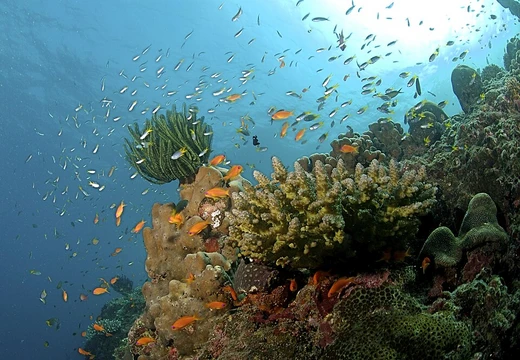
The shallow waters are clear. At night, there is no light pollution, so faint stars are easily visible.
Quick Facts
- Location
- Pacific Ocean
- Total Islands
- 1
- Coastline M
- 6000
- Elevation M
- 9
- Country
- Japan
- Country Admin Divisions Title
- Prefecture
- Country Admin Divisions
- Tokyo
- Population
- no permanent residents. Periodic visits by JMA and JSDF personnel. Visiting permits occasionally granted for specific purposes only.
Facts from the source article.
Lore & Background
Minamitorishima is a triangular, saucer-shaped atoll with a raised outer rim and a central area below sea level, surrounded by fringing reefs enclosing a shallow lagoon. The island has no soil for crops; only papaya, mustard greens, and coconuts are grown, with food brought by supply ships and planes. The sea is clear, and at night there is no light pollution, making stars clearly visible.
The first known sighting was by Spanish Manila galleon captain Andrés de Arriola in 1694, charted as Sebastián López. Later sightings included Captain Bourn Russell in 1830 (who named it 'William the Fourth's Island') and Captain Charles Gelett in 1864 (who called it 'Weeks Island'). Japan annexed the island on 24 July 1898, after Shinroku Mizutani led 46 colonists there in 1886. Sovereignty was disputed before World War I, with the United States sending a warship in 1902 but withdrawing upon finding Japanese inhabitants and a Japanese warship.
During World War II, the Japanese garrison included the 742-man Minamitorishima Guard Unit and the 2,005-man 12th Independent Mixed Regiment. The U.S. Navy bombed the island repeatedly in 1942 and 1943 but never attempted to capture it. Japan resupplied by submarine through a channel cut in the reef. The island surrendered on 31 August 1945 when the destroyer USS Bagley arrived.
Reader's Guide
Minamitorishima's significance lies in its strategic location and its rare-earth mineral deposits. As Japan's easternmost territory, it anchors a vast exclusive economic zone of 428,875 km². The island is off-limits to civilians except for Japan Meteorological Agency staff, with access restricted due to its use by the Japan Self-Defense Forces as an observation station. Reporters and researchers may sometimes obtain entry permits, but no commercial tours or flights visit.
In 2013, deep-sea mud samples taken about 250 km south of the island revealed extremely concentrated rare-earth oxides, with maximum content up to 0.66%. A 2018 study estimated 16 million tons of rare-earth element and yttrium mineralised sediments in the area. In January 2026, the drilling vessel Chikyū conducted the world's first trial extraction of rare-earth-rich mud from approximately 6,000 m depth, retrieving about 35 tonnes of seabed mud. Japan's Deputy Chief Cabinet Secretary Masanao Ozaki called the retrieval 'a meaningful achievement from the perspectives of economic security and comprehensive ocean development.' Full industrialisation is targeted by 2028, though environmental groups raised concerns about deep-sea ecosystem damage.
The island hosts the gecko Perochirus ateles, found in Japan only here and on South Iwo Jima, and land snails (Achatina fulica) with parasites harmful to humans. Marine life includes sea snakes, tuna, sharks, and rare fish.
Did You Know?
- Minamitorishima is the only Japanese territory on the Pacific Plate, past the Japan Trench.
- The island's central area is 1 m below sea level, giving it a saucer-like profile.
- In 2026, the deep-sea drilling vessel Chikyū conducted the world's first trial extraction of rare-earth-rich mud from about 6,000 m depth near the island.
- A species of gecko, Perochirus ateles, is found in Japan only on Minamitorishima and South Iwo Jima.
Strategic Isolation at the Edge of the Pacific
Minamitorishima occupies a singular position in Japanese geography: it is the country's easternmost and most remote territory, sitting alone on the Pacific Plate beyond the Japan Trench. Despite covering only 151 hectares—roughly 370 acres—this tiny coral atoll anchors an exclusive economic zone spanning 428,875 square kilometres of surrounding ocean, making its strategic value vastly disproportionate to its physical size. The island's isolation is staggering. No other landmass exists within a thousand kilometres in any direction, and the nearest Japanese island, South Iwo Jima, lies more than 1,267 kilometres to the west. Even the closest foreign land, East Island in the Mariana chain, is over 1,000 kilometres away. Administratively, the atoll falls under Tokyo's Ogasawara Subprefecture, yet it sits 1,848 kilometres southeast of the capital. Its shape is roughly triangular with a saucer-like profile: a raised outer rim standing five to nine metres above the waterline encircles a central depression that dips one metre below sea level, and a full circuit of the island can be completed in about forty-five minutes on foot.
Rare-Earth Minerals and Deep-Sea Ambition
The waters surrounding Minamitorishima have become central to Japan's efforts to secure critical mineral supply chains. After China imposed export restrictions on rare-earth oxides in 2009, Japanese authorities turned their attention to the deep seabed near the atoll. In early 2013, a JAMSTEC research vessel collected seven mud core samples from depths between 5,600 and 5,800 metres, roughly 250 kilometres south of the island, revealing a sediment layer two to four metres thick with rare-earth concentrations reaching 0.66 percent. A 2018 study expanded the picture dramatically, estimating that the surveyed area held more than sixteen million tonnes of rare-earth and yttrium-bearing sediments at an average grade of 964 parts per million. The breakthrough came in January 2026, when the drilling vessel Chikyū carried out what is described as the world's first trial extraction of rare-earth-rich mud from approximately 6,000 metres below the surface, targeting around thirty-five tonnes of seabed material. Deputy Chief Cabinet Secretary Masanao Ozaki called the retrieval a meaningful step for economic security. Full industrial-scale production is envisioned by 2028, though environmental groups have voiced concerns about impacts on deep-sea ecosystems.
A Closed Territory: Access and Military Presence
Minamitorishima is effectively a restricted zone. No civilians are permitted to live on the island, and the only people present are small numbers of personnel from the Japan Meteorological Agency, the Japan Self-Defense Forces, and the Japan Coast Guard, all serving limited tours of duty. The JSDF maintains an observation station on the atoll, and this military use is the stated reason civilian sightseeing and commercial tourism remain prohibited. There are no scheduled flights or boat tours that call at the island. Access for outsiders is tightly controlled: Japan Meteorological Agency staff are the primary exception, while journalists, documentary crews, and scientific researchers may occasionally be granted an entry permit, but there is no open or routine pathway for the general public to visit. The island's remoteness compounds the difficulty—supply ships and aircraft must deliver all provisions, as the atoll's soil is too poor to support meaningful agriculture. The only food cultivated locally consists of papaya, mustard greens, and coconuts, while saltwater fish are caught in the surrounding waters. Everything else, from equipment to fresh produce, arrives by sea or air, reinforcing the sense of a self-contained, purpose-driven outpost rather than a settled community.
Life in the Lagoon: Ecology and Wildlife
The atoll's fringing reefs stretch fifty to three hundred metres outward from the shore, enclosing a shallow lagoon that connects to the open ocean through narrow channels on its southern and northeastern sides. Beyond the reef edge, the seabed drops sharply to depths exceeding one thousand metres. The water in the shallows is notably clear, and because no artificial lighting exists on the island, the night sky is free of light pollution, making faint stars visible to the unaided eye. The local fauna is modest but distinctive. A gecko species, Perochirus ateles, lives on Minamitorishima and, within Japan, is found nowhere else except South Iwo Jima; researchers believe these lizards reached the islands by drifting on timber from Micronesia. Large populations of the land snail Achatina fulica also inhabit the atoll, though these carry parasites that pose a risk to human health. In the surrounding waters, sea snakes, tuna, sharks, and several rare fish species have been recorded, while small fish populate the shallow reef areas. The combination of isolation and limited terrestrial habitat has produced a small, self-contained ecosystem that is as fragile as it is unusual.
Frequently Asked Questions
What is Minamitorishima?
Minamitorishima, also referred to as Marcus Island, is a small coral atoll in the northwestern Pacific that serves as Japan's most remote and easternmost territory. It is administered under Tokyo's Ogasawara Subprefecture and sits roughly 1,848 kilometers southeast of the capital.
How large is Minamitorishima?
The atoll spans only about 151 hectares (roughly 370 acres) of land, with its highest points reaching just 5 to 9 meters above sea level. Its central lagoon dips approximately 1 meter below the waterline, making it an extremely low-lying feature.
Why is Minamitorishima strategically important to Japan?
Despite its tiny land area, the atoll anchors an exclusive economic zone of roughly 428,875 square kilometers, granting Japan extensive maritime rights over surrounding Pacific waters. It also underlies notable rare-earth mineral deposits, adding significant resource value to its remote location.
What makes Minamitorishima geologically unique?
It is the only Japanese landmass that rests directly on the Pacific Plate, positioned beyond the Japan Trench. This sets it apart from virtually every other Japanese island, which sit on the Okhotsk or Philippine Sea plates.
How isolated is Minamitorishima?
The nearest other island is East Island in the Mariana chain, located about 1,015 kilometers to the west-southwest. This extreme remoteness makes it one of the most isolated coral atoll ecosystems in the central Pacific.
More in Coral Reefs, Part 2 1-24
Spotted an error? Know more?
Reader corrections go straight into our review queue. Suggest an edit · How this site is sourced