Los Roques Archipelago National Park
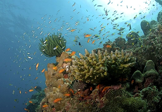
Largest marine park in the Caribbean, with a diverse coral reef system.

Los Roques Archipelago National Park, a marine protected area in the Caribbean Sea north of Venezuela, was created on August 8, 1972, under President Rafael Caldera. It covers the Los Roques Archipelago—a coral atoll stretching roughly 36 kilometers east to west and 24.6 kilometers north to south—which includes about 50 islands and around 292 cays and shoals. Spanning 221,120 hectares of both land and sea, it holds the title of the largest marine park in the Caribbean.
Only Gran Roque, an island of 1.7 square kilometers with roughly 1,200 residents, has a permanent population. Other islands and cays popular with tourists include Francisquí, Crasquí, Madrisquí, Pirata, Fernando, Noronquí, and Dos Mosquises. The park shelters one of the Caribbean’s most diverse and well-preserved coral reef systems. The lack of rivers or permanent freshwater sources, along with strict commercial rules due to its national park status, limits tourism development. About 90% of Venezuela’s lobsters come from Los Roques, though fishing has been overtaken by tourism as the main economic activity since the 1990s. The highest point in the park is just 130 meters above sea level. Depths in the southern part reach up to 1,700 meters, while the north averages less than 15 meters.
**History** Human activity in Los Roques likely began near the end of the first millennium AD. Archaeological studies suggest indigenous seafarers from Lake Valencia and Venezuela’s central coast visited regularly for rituals, gathering queen conch, fishing, hunting sea turtles, and extracting salt. During the colonial era, people came for pearls, salt, and mangroves, while smugglers and pirates used the intricate coastline as hideouts. In the late 1800s, Venezuela’s government made a deal with a Dutch entrepreneur to mine guano, a job mainly done by workers from Aruba, Bonaire, and Curaçao. Many islands have names ending in “quí,” from the English word “key” (meaning cay), dating to this period. By the mid-20th century, fishermen from Margarita Island settled permanently on eight islands; after the park’s creation, only Gran Roque remained inhabited.
**Geography** The park’s 221,120 hectares are over 80% underwater. The climate is mild, with an average annual temperature of 28°C and about 250 mm of rain per year.
Quick Facts
- Iucn Category
- II
- Location
- Federal Dependencies of Venezuela
- Nearest City
- La Guaira
- Established
- 1972-08-08
Facts from the source article.
Lore & Background
Human presence in Los Roques is estimated to date back to the end of the first millennium AD. According to recent archaeological studies, the archipelago was a frequent destination for indigenous seafarers from Lake Valencia and the central coast of Venezuela, who travelled there to hold ritual festivals and to gather queen conch, fish, hunt sea turtles and extract salt. Later, during the colonial period, the islands became frequented by people drawn by pearls, salt and mangroves. Smugglers and pirates used its intricate coasts as hideouts. In the second half of the 19th century, the Venezuelan government signed an agreement with a Dutch entrepreneur for the extraction of guano, an activity carried out mainly by people from Aruba, Bonaire and Curaçao. The unusual names of many of the islands ending in the syllable quí (derived from the English word 'key', meaning cay) come from this period. In the mid-20th century, Venezuelan fishermen from Margarita Island began to settle permanently in the islands, initially on eight of them and, after the creation of the national park, only on Gran Roque.
Reader's Guide
Los Roques Archipelago National Park is notable for containing one of the most diverse and best-preserved coral reef systems in the Caribbean Sea. The park is administered by the National Institute of Parks (INPARQUES) and is listed under IUCN Category II. It was designated a Ramsar Wetland of International Importance on 4 September 1996. Studies of the area's coral reefs have documented signs of recovery for the endangered Acropora palmata coral in recent decades. Long-running monitoring also covers the populations of queen conch and Caribbean spiny lobster, both fisheries of significant economic importance to local communities. About 90% of the lobsters consumed in Venezuela come from Los Roques. Since the 1990s, fishing has been displaced by tourism as the principal economic activity. The main constraint on tourism development, besides the strict commercial controls imposed by its national park status, is the lack of rivers and other permanent fresh water sources. Geologically, Los Roques has the distinction of being the only coral atoll in the world whose formation did not involve volcanic processes.
Atoll Architecture & Tropical Climate
The archipelago's physical form is defined by its atoll architecture. The major islands are ringed by two external coral barriers, enclosing a shallow central lagoon and sandy shallows. Across the full 40.61 square kilometers of land, the park encompasses roughly 1,500 square kilometers of coral reef, 42 coral cays surrounding a 400-square-kilometer lagoon, two barrier reefs stretching 24 kilometers to the east and 32 kilometers to the south, and approximately 300 sand banks, islands, and cays. Land sizes range from Cayo Grande at 15.1 square kilometers down to Gran Roque at 1.7 square kilometers, with Francisqui, Nordisqui, Madrisqui, and Crasqui among other notable islets. The climate is warm and dry, averaging 27.3 degrees Celsius in the summer months and peaking at 34 degrees. Annual rainfall is modest at roughly 257 millimeters, with the wettest month being November and the driest April. Constant winds temper the heat, and clear skies dominate year-round, with relative humidity sitting at 83 percent.
Layers of Inhabitation & Cultural Naming
Long before European contact, Caribbean aborigines visited these islands to harvest large sea snails called botutos, fish, hunt turtles, and extract salt. Remnants of that era survive in the form of salt-flat constructions with dikes, stone pathways, and house foundations. Permanent settlement came later, when fishermen from Margarita Island brought their families to make a home here. In 1589, the governor of the Venezuelan province formally claimed the islands for the Spanish colony, though the Dutch simultaneously regarded Los Roques as part of their Curaçao territory—a claim still echoed in an 1836 publication by M.D. Teenstra. During the eighteenth century, the Sociedad Mercantil Real Compañía Guipuzcoana established operations here and bestowed names on Gran Roque, Carenero, and Cayo Sal. The nineteenth century saw salt mines and guano extraction. Around 1886, settlers from Aruba, Curaçao, and the Netherlands Antilles arrived, leaving behind island names ending in "quí," a local rendering of the English word "key."
Shifting Governance & Administrative Identity
The archipelago's governance has shifted repeatedly over more than a century. In 1871, President Antonio Guzmán Blanco created the Territorio Colón, designating Gran Roque as its administrative center. A bubonic plague epidemic in La Guaira at the start of the twentieth century led the government to use Gran Roque as a quarantine site. By 1910, families from Margarita Island were consolidating a small town there. The islands were formally integrated into Venezuela's Federal Dependencies on 20 July 1938, and the population grew from 484 in 1941 to 559 by 1950. In 1990, Presidential Decree 1214 established the Single Authority of the Los Roques Area, granting a special administrative status within the Federal Dependencies. A further reorganization in 2011 folded the archipelago into the Miranda Insular Territory, with Gran Roque as its capital. By 2014, local authorities and residents had codified communal coexistence norms specific to the archipelago.
Scientific Research & Conservation Legacy
In 1972, recognizing the archipelago's extraordinary seabird diversity and rich aquatic ecosystems, the Venezuelan government declared Los Roques a National Park. Shortly after, the Los Roques Scientific Foundation was established, setting up laboratories and research facilities on the island of Dos Mosquises. Its work spans archaeology, ichthyology, turtle biology, mollusk ecology, coral and sponge studies, fisheries research, and oceanography. The foundation also conducted a population registry in 1987, documenting 847 inhabitants on Gran Roque, of whom 663 were permanent residents and the remainder were sailors based on Isla Margarita. In 1978, Venezuela and the Kingdom of the Netherlands signed a marine delimitation agreement, settling longstanding territorial questions. The 1990 creation of the Single Authority was explicitly aimed at promoting sustainable development, and the 2012 approval of organic regulations for the Insular Territory of Miranda formalized governance across Los Roques, La Orchila, and Las Aves.
Frequently Asked Questions
What is Los Roques Archipelago National Park?
It is a marine protected area situated in the Caribbean Sea just north of Venezuela, encompassing the Los Roques coral atoll. The park was officially created on August 8, 1972, during the presidency of Rafael Caldera.
How big is Los Roques Archipelago National Park and what record does it hold?
The park spans 221,120 hectares of combined land and sea, stretching roughly 36 km east-to-west and 24.6 km north-to-south. That vast footprint earns it the distinction of being the largest marine park in the entire Caribbean region.
What does the Los Roques Archipelago National Park actually consist of?
The atoll is made up of approximately 50 islands along with around 292 cays and shoals scattered across its waters. Together these landforms and their surrounding reefs form the park's diverse coral-reef ecosystem.
Who actually lives inside Los Roques Archipelago National Park?
Only Gran Roque, the largest island at 1.7 square kilometers, supports a permanent community of roughly 1,200 residents. Every other island, cay, and shoal within the park remains uninhabited.
Why do coral-reef fans and marine biologists keep pointing to Los Roques Archipelago National Park?
Because it protects one of the Caribbean's most extensive and biodiverse coral-reef systems within a single, legally designated reserve. Its sheer scale—over 221,000 hectares of interconnected atolls and reefs—makes it a key reference point for anyone studying Caribbean reef ecology.
More in Coral Reefs, Part 2 1-24
Spotted an error? Know more?
Reader corrections go straight into our review queue. Suggest an edit · How this site is sourced