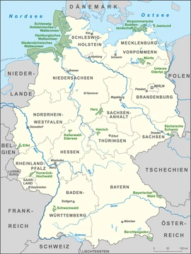
Lower Saxon Wadden Sea National Park
Protected intertidal ecosystem and UNESCO World Heritage Site.

Established in 1986, the Lower Saxon Wadden Sea National Park stretches from the Dollart Bay on the Dutch border in the west to Cuxhaven and the Outer Elbe shipping channel in the east. It covers the East Frisian Islands, mudflats, and salt marshes across roughly 345,800 hectares. The park’s headquarters are in Wilhelmshaven. In June 2009, it was designated a UNESCO World Heritage Site alongside the Schleswig-Holstein Wadden Sea and the Dutch Wadden Sea, recognized for its distinctive intertidal ecosystem and rich biodiversity.
The park protects mudflats, salt marshes, beaches, dunes, and estuaries along the North Sea, with a focus on the typical wildlife and plants of the Wadden Sea. The coastline is remarkably flat, with the seabed sloping gradually but varying in steepness across different areas. Twice daily, tides deposit sand, clay, and silt, while wind shapes dunes from fine sand exposed on the flats. After tropical rainforests, the Wadden Sea is the second most productive ecosystem by living biomass. Its life includes diatoms, snails, worms, mussels, and shrimp. A common inhabitant is the lugworm, which burrows in a U-shaped tube beneath the mud.
Over 10,000 animal and plant species live in the park, with up to 4,000 specialized for this food-rich habitat. Shelduck feed on snails covering the flats; roughly 180,000 shelduck from northwestern Europe molt here from July to September, along with about 200,000 eider ducks. Around 1,000 pairs of eiders breed in the North Sea mudflats, mostly on Amrum. The area also serves as a stopover for northern breeding birds, with 10–12 million waders, geese, ducks, and gulls gathering across the entire Wadden Sea to build fat reserves. Seals are found on sandbanks, salt marshes, beaches, and dunes. Salt marshes host breeding pied avocets and terns, plus sea holly and sea lavender in summer. Dunes are anchored by beachgrass with its extensive roots.
Protection began with the 1971 Ramsar Convention, which designated the current park areas and Dollart Bay as wetlands of international importance. In 1979, Hans-Joachim Augst and Holger Wesemüller proposed a zoning model based on varying conservation value. The 1982 Lower Saxon regional development program set a national park for the “East Frisian Islands and coast” as a planning goal.
Quick Facts
- Iucn Category
- II
- Area
- 345.8 km2
- Location
- Lower Saxony
- Established
- 1986-01-01
- World Heritage Site
- 2009
Facts from the source article.
Lore & Background
The national park was preceded by protections under the Ramsar Convention of 1971, which designated the present-day park regions and the Dollart Bay as 'wetlands of international importance'. In 1979 Hans-Joachim Augst and Holger Wesemüller submitted a report developing a zoning model based on different levels of importance of areas worth protecting. The 1982 Lower Saxon regional development programme set the development of a national park for the 'East Frisian Islands and coast' as a state planning objective, and plans for a comprehensive national park began in 1983. The cabinet decided to approve the national park in principle in early 1984, and on 1 January 1986 the national park regulation came into force.
Reader's Guide
The Lower Saxon Wadden Sea National Park protects a highly productive intertidal ecosystem, second only to tropical rainforest in living biomass. It hosts more than 10,000 animal and plant species, including up to 4,000 specialized in the Wadden Sea habitat. The park is a critical resting and feeding area for migratory birds, with about 10–12 million waders, geese, ducks, and gulls gathering in the whole Wadden Sea area. It also supports breeding populations of shelduck, eider, and seals. The park's zoning system—with Zone I (68.5% of area) strictly protected, Zone II (31.0%) allowing limited entry, and Zone III (0.5%) for recreation—aims to balance conservation with tourism. Controversy arose in 2001 when the Lower Saxon State Parliament amended the park law to remove or downgrade many areas for tourism, leading to a complaint to the EU Commission by the conservation group Wattenrat Ost-Friesland. The complaint was closed in 2006 after Germany identified sufficient Special Areas of Conservation, though the group argued the park was in a worse state. The park became a UNESCO World Heritage Site in 2009, though some viewed the nomination as a marketing tool for tourism.
Did You Know?
- The national park has an area of about 345,800 hectares (1,335 sq mi).
- The Wadden Sea is the second most productive ecosystem after tropical rainforest in terms of living biomass.
- About 10–12 million waders, geese, ducks, and gulls gather in the whole Wadden Sea area.
- The park includes land on the islands of Baltrum, Borkum, Langeoog, Juist, Mellum, Memmert, Minsener Oog, Norderney, Spiekeroog and Wangerooge.
Founding and Political Evolution
The Lower Saxon Wadden Sea National Park traces its origins to a 1979 report by Hans-Joachim Augst and Holger Wesemüller, who proposed a zoning framework that ranked different stretches of the Wadden Sea by their conservation value. That vision gained momentum when the 1982 Lower Saxon regional development programme formally designated a national park for the East Frisian Islands and coast as a state planning goal. Detailed planning followed in 1983, and by early 1984 the state cabinet gave its principled approval. The park's founding regulation took effect on 1 January 1986, encompassing roughly 345,800 hectares of mudflats, salt marshes, and islands stretching from the Bay of Dollart near the Dutch border eastward to Cuxhaven and the Outer Elbe shipping channel. The administrative body is based in Wilhelmshaven. The original 1986 regulation was later elevated to a full law in 1999. However, in July 2001 the Lower Saxon State Parliament amended that law, removing numerous areas or downgrading their zoning to accommodate tourism. To offset these losses, marine zones off Borkum and Baltrum and a former nature reserve in the eastern Dollart were added, pushing the protected footprint from 240,000 to nearly 280,000 hectares.
A Supercharged Intertidal Ecosystem
The Wadden Sea ranks as the second most productive ecosystem on Earth, surpassed only by the tropical rainforest in terms of living biomass. This extraordinary fertility stems from the region's remarkably flat topography; the seabed slopes downward by mere centimetres per kilometre, and twice each day the tide sweeps sand, clay, and silt across the intertidal zone. Wind lifts fine grains from the exposed mudflats to build the dunes that line the coast. Within this nutrient-rich environment, more than 10,000 animal and plant species thrive, and up to 4,000 of them are specialists adapted specifically to Wadden Sea conditions. The lugworm, a signature resident of the sandy mudflats, burrows into a U-shaped tube beneath the surface. Shelducks feed on the hundreds of thousands of snails that carpet the flats, and roughly 180,000 birds from north-western Europe's shelduck population spend their July-to-September moulting season here. About 200,000 eiders do the same, while approximately 1,000 breeding pairs use the North Sea mudflats, predominantly on the island of Amrum. In total, 10 to 12 million waders, geese, ducks, and gulls congregate across the Wadden Sea area, and seals rest on sandbanks, salt marshes, and dunes.
Layers of International Protection
The park's conservation credentials are reinforced by a dense web of international and European designations. Under the 1971 Ramsar Convention, the park's regions and the Dollart Bay have long been recognised as wetlands of international importance. In 1992, the entire national park was designated a biosphere reserve under UNESCO's 'Man and the Biosphere' programme. A landmark came in June 2009, when the Lower Saxon Wadden Sea, together with its counterparts in Schleswig-Holstein and the Netherlands, was inscribed as a UNESCO World Heritage Site, a recognition that underscored the intertidal ecosystem's uniqueness and extraordinary biodiversity. At the European level, every zone of the park qualifies as a bird reserve under the EU Birds Directive, while Zones I and II additionally hold Special Area of Conservation status under the Habitats Directive, placing them within the Natura 2000 network. The IUCN classifies the park as a Category II national park. The 2008 joint German proposal to UNESCO for World Heritage nomination preceded the successful 2009 inscription, cementing the Wadden Sea's place among the world's most treasured natural sites.
Tourism Pressures and Conservation Battles
The park's history is marked by tensions between economic development and ecological protection. In July 2001, the Lower Saxon State Parliament amended the national park law, stripping protection from numerous areas or downgrading their zoning to accommodate tourism. The East Frisian conservation group Wattenrat Ost-Friesland responded in January 2002 by filing a complaint with the European Commission in Brussels, arguing that more than 80 zones, predominantly on the East Frisian islands, had been sacrificed for tourist facilities at the expense of plant habitats and bird breeding or migration sites. The Commission folded the appeal into ongoing infringement proceedings against Germany. After more than four years, the Commission closed the case in October 2006, noting that Germany had identified sufficient Special Areas of Conservation. Wattenrat rejected this outcome, contending that the park had previously been part of a designated special area and bird reserve and was now in a worse state of repair, contrary to Natura 2000 provisions. The group maintained the EU was endorsing economically motivated changes. The twentieth anniversary in July 2006 at Neßmersiel was marked by Lower Saxon nature conservation organizations under WWF auspices with a critical 'national park balance' report cataloguing the park's conflicting uses.
Frequently Asked Questions
What is the Lower Saxon Wadden Sea National Park?
It is a Category II national park in Lower Saxony, Germany, protecting the East Frisian Islands, surrounding mudflats, and salt marshes along the North Sea coast. The park stretches from the Dollart Bay near the Dutch border all the way to Cuxhaven and the Outer Elbe shipping channel.
When was the Lower Saxon Wadden Sea National Park established?
The park was created in 1986. It later gained international recognition in June 2009 when it was inscribed as a UNESCO World Heritage Site together with the Schleswig-Holstein and Dutch Wadden Sea sections.
How big is the Lower Saxon Wadden Sea National Park?
The protected area covers roughly 345,800 hectares (about 1,335 square miles) of coastal and intertidal landscape.
Where is the Lower Saxon Wadden Sea National Park headquartered?
The park's administrative headquarters are located in Wilhelmshaven, a port city in the western part of Lower Saxony.
Why is the Lower Saxon Wadden Sea National Park important?
It safeguards one of the world's largest intertidal ecosystems, home to mudflats, salt marshes, dunes, and estuaries that support extraordinary biodiversity. Its 2009 UNESCO designation underscores the site's global significance as a living coastal landscape.
More in National parks of Germany 1-19
Spotted an error? Know more?
Reader corrections go straight into our review queue. Suggest an edit · How this site is sourced