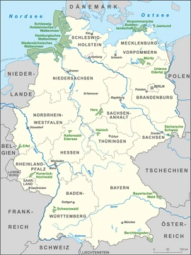
Lower Oder Valley International Park
A German-Polish nature reserve along the Oder river.

Straddling the border between Germany and Poland, the Lower Oder Valley International Park is a joint nature reserve. On the German side, it covers the flat western banks of the Oder River in Brandenburg’s Uckermark district; on the Polish side, it takes in the steeper eastern banks in the Gryfino and Police counties of the West Pomeranian Voivodeship to the north. The park was established in 1992 following a decision by the German-Polish Environmental Council, with the environment ministers of Germany, Poland, and Brandenburg, along with the voivode of Szczecin, signing off on the plan.
The German core area is designated as the Nationalpark Unteres Odertal (Lower Oder Valley National Park), which has an information centre at Criewen. The Polish core area is the Park Krajobrazowy Dolina Dolnej Odry (Lower Oder Valley Landscape Park). Together, the core zones cover 165 square kilometres (64 square miles)—105 square kilometres (41 square miles) in Germany and 60 square kilometres (23 square miles) in Poland. When adjoining nature reserves in both countries are included, the total protected area expands to 1,173 square kilometres (453 square miles).
The western shore is flat and lined with levees. To manage water levels and prevent major floods, these dikes are regularly opened in winter and spring, allowing the Oder to spread freely across the floodplains. The water remains until April, when the dikes are closed and the leftover water is drained away.
The floodplains are a Special Protection Area for birds, hosting species like the black stork, the aquatic warbler, and the corn crake. Mammals such as the European otter and the European beaver also live here. Among the plant life is the submediterranean pubescent oak.
For minor traffic offenses, police can collect fines on the spot. If you lack cash, credit or debit cards are usually accepted. If you cannot or choose not to pay—you have the legal right to refuse—your vehicle may be impounded at additional cost, though in most cases you will likely receive a citation to appear in court later.
Quick Facts
- Other Name
- Międzynarodowy Park Dolina Dolnej Odry (Polish), / Internationalpark Unteres Odertal (German)
- Location
- Lower Oder Valley, on the border between Germany and Poland
- Nearest City
- Schwedt (Germany), Gryfino (Poland)
- Area
- 1173 km2
- Established
- 1992
Facts from the source article.
Lore & Background
The Lower Oder Valley International Park consists of a German core area, the Nationalpark Unteres Odertal (Lower Oder Valley National Park), and a Polish core area, the Park Krajobrazowy Dolina Dolnej Odry (Lower Oder Valley Landscape Park). An information centre is located at Criewen. The flat western shore of the Oder features several levees, which are regularly opened in winter and spring to control water levels and prevent high floods, allowing water to flow freely into extensive floodplains until April, when the dikes are closed and remaining water is drained.
Reader's Guide
The Lower Oder Valley International Park represents a significant cross-border conservation effort, established in 1992 by a decision of the German-Polish Environmental Council. Its total area, including adjoining nature reserves, spans 1,173 km², with the German portion covering 105 km² and the Polish portion 60 km². The park is notable for its floodplain management, where levees are opened seasonally to mimic natural flooding cycles. It serves as a Special Protection Area for birds, hosting species such as the black stork, aquatic warbler, and corn crake, as well as mammals like the European otter and European beaver. The flora includes the submediterranean pubescent oak. The park's legacy lies in its model of international cooperation for environmental protection and habitat preservation.
Did You Know?
- The park was created by decision of the German-Polish Environmental Council in 1992.
- The German core area is the Nationalpark Unteres Odertal, and the Polish core area is the Park Krajobrazowy Dolina Dolnej Odry.
- The flat western shore features levees that are opened in winter and spring to allow water into floodplains.
- The park is a Special Protection Area for birds including the black stork, aquatic warbler, and corn crake.
Geography & Structure
The Lower Oder Valley International Park straddles the Oder river (known as Odra in Polish), forming a transboundary nature reserve between Germany and Poland. On the western bank, the reserve occupies territory within the Uckermark district of Brandenburg, while the eastern, steeper banks fall under the Gryfino and Police counties in Poland's West Pomeranian Voivodeship, situated further north along the river's course. The core protected zones differ in designation on each side of the border: Germany's portion is formally named the Nationalpark Unteres Odertal, while Poland's is the Park Krajobrazowy Dolina Dolnej Odry. A visitor information centre is located in the small town of Criewen, serving as a gateway for those exploring the German side. The contrast between the flat western shore and the steep eastern banks gives the valley a distinctive topographic character that shapes both its ecology and its management challenges.
Creation & Governance
In 1992, the German-Polish Environmental Council made the pivotal decision to establish the Lower Oder Valley International Park as a joint conservation effort. The initiative was formalized by the environment ministers of Germany and Poland, the environment minister of the Brandenburg state, and the voivode of Szczecin, reflecting a multi-layered governmental commitment to cross-border environmental stewardship. The resulting protected landscape encompasses a core area of 165 square kilometres (64 square miles), with Germany accounting for 105 square kilometres (41 square miles) and Poland contributing 60 square kilometres (23 square miles). When adjoining nature reserves on both sides of the border are included, the total protected territory expands to 1,172 square kilometres (453 square miles). This framework of layered protection—core park areas supplemented by surrounding reserves—creates a mosaic of conservation zones that stretches well beyond the immediate river corridor, ensuring that connected habitats on both national territories receive coordinated oversight.
Hydrology & Floodplain Management
The flat western shore of the Oder is defined by a network of levees that play a central role in the valley's seasonal rhythm. During winter and spring, these dikes are deliberately opened to allow the river's water to spill freely into the surrounding floodplains. This controlled inundation serves a dual purpose: it helps regulate the river's water level and provides a critical buffer against high-flood events that could otherwise threaten downstream communities. The floodplains remain submerged until April, at which point the dikes are closed once again and the residual standing water is actively drained from the landscape. This annual cycle of flooding and drying creates dynamic wetland conditions that are essential to the valley's ecological character. The contrast between the engineered levee system on the flat German side and the naturally steep eastern banks on the Polish side underscores how the river's behavior is shaped by both natural topography and human water management infrastructure.
Biodiversity & Ecosystem
The Lower Oder Valley International Park is designated as a Special Protection Area for birds, underscoring its importance as an avian habitat. The seasonal floodplains and wetland environments support a range of notable bird species, including the black stork, the aquatic warbler, and the corn crake—each of which depends on the specific wetland conditions the valley provides. Beyond birds, the waterways and riparian zones are home to the European otter and the European beaver, both semi-aquatic mammals that thrive in the riverine and floodplain habitats. On the plant side, the valley harbors the submediterranean pubescent oak, a species whose presence signals the area's particular climatic and soil conditions. The combination of open water, seasonal wetlands, and varied vegetation creates a layered ecosystem where multiple trophic levels interact. This biodiversity is not incidental but is a direct consequence of the valley's hydrological regime, its transboundary protection status, and the careful management of its floodplain dynamics.
Frequently Asked Questions
What is the Lower Oder Valley International Park?
It is a transboundary nature reserve that straddles the German-Polish border along the Oder River, functioning as both a national park and a landscape park. The designation was created to jointly protect the river valley's ecosystems on both sides of the border.
Where is the Lower Oder Valley International Park located?
The German portion sits on the flat western banks of the Oder within Brandenburg's Uckermark district, while the Polish portion covers the steeper eastern banks in Gryfino and Police counties of the West Pomeranian Voivodeship.
How large is the Lower Oder Valley International Park?
The reserve encompasses a total of 1,173 km² (453 sq mi) across both countries. Its core protected areas measure 105 km² on the German side and 60 km² on the Polish side.
When and how was the Lower Oder Valley International Park established?
The park came into being in 1992 following a resolution by the German-Polish Environmental Council. The plan was formally signed off by the environment ministers of Germany, Poland, and the state of Brandenburg, together with the voivode of Szczecin.
Why is the Lower Oder Valley International Park important?
It stands out as a rare example of two neighboring nations collaborating to protect a shared river valley and its floodplain habitats. The joint management model makes it a notable case of cross-border conservation in Europe.
More in National parks of Germany 1-19
Spotted an error? Know more?
Reader corrections go straight into our review queue. Suggest an edit · How this site is sourced