Black Forest National Park
First national park in Baden-Württemberg, opened in 2014.

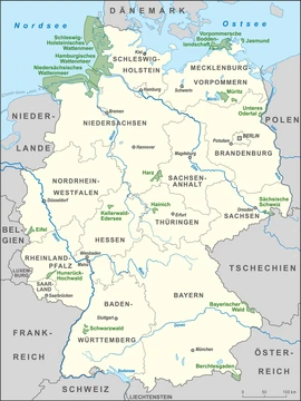
The Black Forest National Park (German: Nationalpark Schwarzwald) is a national park in the state of Baden-Württemberg in the southwest of Germany. It was created on 1 January 2014 and officially opened on 3 May 2014, making it the first national park in Baden-Württemberg. The park covers an area of 10,062 hectares and is located on the main crest of the Northern Black Forest, comprising two separate areas around Ruhestein and Hoher Ochsenkopf/Plättig.
Quick Facts
- Iucn Category
- II
- Location
- Baden-Württemberg, Germany
- Nearest City
- Baden-Baden, Freudenstadt
- Area
- 10062 ha
- Established
- 2014-01-01
Facts from the source article.
Lore & Background
The Black Forest National Park was created on 1 January 2014, following a vote by the state parliament on 28 November 2013. Its establishment was politically controversial: it was opposed by Baden-Württemberg's opposition parties (CDU and FDP), representatives of the timber industry, and some of the affected population, while being supported by the SPD and Greens, conservation associations, and other parts of the populations of the Northern Black Forest. It is the first and only national park in Baden-Württemberg.
Reader's Guide
The Black Forest National Park is significant as the first national park in Baden-Württemberg, marking a milestone in the state's conservation history. Its creation was contentious, reflecting tensions between economic interests (timber industry) and environmental protection. The park comprises two separate areas—Ruhestein (7,615 ha) and Hoher Ochsenkopf/Plättig (2,447 ha)—roughly 3.5 km apart, with plans announced in 2021 by environment minister Thekla Walker to eventually connect them. The park protects diverse landscapes, including summits like the Hornisgrinde, tarns such as Wildsee and Huzenbacher See, and headwaters of the Murg. Its legacy includes ongoing debates about expansion and integration of the two sections.
Did You Know?
- The park was officially opened on 3 May 2014.
- The park comprises two separate areas roughly 3.5 km apart.
- In 2021, environment minister Thekla Walker announced plans to extend and eventually connect the two parts.
A Contested Birth
The creation of Germany's newest national park in the southwest was far from a foregone conclusion. When the state parliament of Baden-Württemberg cast its vote on 28 November 2013, the measure split the political landscape along charged lines. The Social Democrats and the Greens championed the initiative, backed by conservation groups and a significant portion of residents in the Northern Black Forest who saw the designation as a long-overdue shield for their forests. On the other side, the Christian Democratic Union and the Free Democrats raised objections, and the timber industry voiced strong resistance, fearing restrictions on harvesting. Some local communities also pushed back against what they perceived as an encroachment on traditional land use. Despite the friction, the park came into legal existence on 1 January 2014, and its gates were formally opened to the public on 3 May of that year. The result was a singular achievement: the first—and to date the only—national park in the entire state of Baden-Württemberg, a distinction that underscored both the ambition and the difficulty of the political compromise that produced it.
Two Worlds, One Park
Rather than forming a single contiguous block, the park is split into two distinct zones separated by roughly 3.5 kilometres of intervening land, the Forbach parish of Hundsbach. The larger of the two, the Ruhestein zone at 7,615 hectares, climbs to approximately 1,150 metres near Dreifürstenstein, the southeasternmost crown of the Hornisgrinde, the highest peak in the northern Black Forest. Surrounding summits include the Vogelskopf at 1,056 metres, the Schliffkopf and Seekopf both at 1,054, the Riesenköpfle at 1,001, and the Leinkopf at 992. This zone also shelters the glacial tarns of Wildsee, Huzenbacher See, and Buhlbachsee, as well as the upper Schönmünz valley and the headwaters of the Rechtmurg and Rotmurg, the twin streams that feed the Murg. On the western flank of the Schliffkopf the terrain drops to the All Saints Waterfalls, where the park reaches its lowest and most westerly point near 500 metres. The smaller High Ochsenkopf/Plättig zone, at 2,447 hectares, centres on the upper Schwarzenbach valley and features peaks such as the High Ochsenkopf at 1,055 metres, the Mehliskopf at 1,008, the Badener Höhe at 1,003, and the Nägeliskopf at 994, with its lowest point just under 500 metres where the Schwarzbach and Raumünzach streams meet.
Who Owns the Wild
The park's legal boundaries are not simply drawn around wilderness; they carefully exclude human settlements and infrastructure. In the High Ochsenkopf/Plättig zone, the village of Herrenwies is carved out, along with smaller parcels around Plättig, Sand, and the youth hostel at Badener Höhe. The zone's state forest land falls primarily under the municipality of Forbach in the Rastatt county, while the towns of Bühl and Baden-Baden hold municipal forest holdings near Plättig. To the northeast the park abuts the Schwarzenbach Reservoir, and to the west it stops at the Bühlerhöhe, just beyond the Black Forest High Road. In the Ruhestein zone the exclusions are more numerous: the Ruhestein summit itself with its two ski slopes and the Great Ruhestein Ski Jump, the Darmstädter Hut, the Schliffkopf Hotel, the Rotmurg Hunting Lodge, and the small hamlet of Schonmünz (Volzenhäuser) all sit outside the boundary. The state forest here is administered mainly by the collective municipality of Baiersbronn in the Freudenstadt county, with additional portions belonging to Oppenau, Ottenhöfen, and Seebach in the Ortenaukreis. This patchwork of municipal ownership reflects the complex governance that underpins the park's daily management.
Looking Ahead
Though it has existed for barely a decade, the park already carries ambitions that reach well beyond its current 10,062-hectare footprint. In 2021, Thekla Walker, the state minister for the environment representing the Greens, publicly outlined a plan to extend the protected area and, over the following years, physically connect the two currently separate zones into a single unbroken expanse of national park land. Such a merger would eliminate the 3.5-kilometre gap of the Hundsbach parish that presently divides the Ruhestein and High Ochsenkopf/Plättig sections, creating a continuous corridor of forest on the main crest of the Northern Black Forest. The park already sits within the broader Central/North Black Forest Nature Park, a larger conservation framework that stretches across the region. As the sole national park in Baden-Württemberg, the Schwarzwald designation carries symbolic weight: it represents the state's first formal commitment to letting a substantial tract of forest evolve without active forestry management. Whether the extension plans materialise will depend on the same mix of political will, industry interests, and local sentiment that shaped the original 2013 vote, but the direction of travel is clear—more forest, fewer boundaries, and a deeper integration of the two halves into one living landscape.
Frequently Asked Questions
What is the Black Forest National Park and when did it open?
It is a protected nature reserve on the main ridge of the Northern Black Forest in Baden-Württemberg, Germany. Formally established on 1 January 2014, it was officially opened to the public on 3 May 2014.
Why is the Black Forest National Park a big deal for Baden-Württemberg?
It is the very first national park ever designated in the state, marking a milestone in Baden-Württemberg's conservation history. Before 2014, the state had no area with that level of protected status.
How large is the Black Forest National Park and where is it located?
The park covers 10,062 hectares (roughly 100.62 km²) along the crest of the Northern Black Forest. It sits entirely within the state of Baden-Württemberg in southwestern Germany.
Is the Black Forest National Park one single continuous area?
No, it is split into two separate zones. The larger Ruhestein section spans 7,615 hectares, while the smaller Hoher Ochsenkopf/Plättig section makes up the remaining 2,447 hectares.
What type of protected area is the Black Forest National Park?
It holds the designation of a national park, the highest tier of nature protection in Germany. This means its ecosystems, old-growth forests, and native wildlife are managed primarily to allow natural processes to run with minimal human intervention.
More in National parks of Germany 1-19
Spotted an error? Know more?
Reader corrections go straight into our review queue. Suggest an edit · How this site is sourced