
Dardanus Sulcus
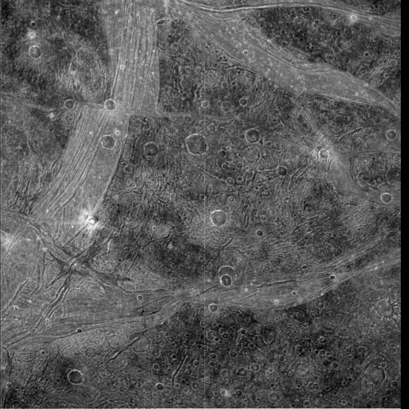
A long, bright grooved terrain on Ganymede, younger than surrounding dark regions.

NASA/JPL · Public domain
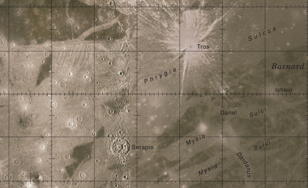
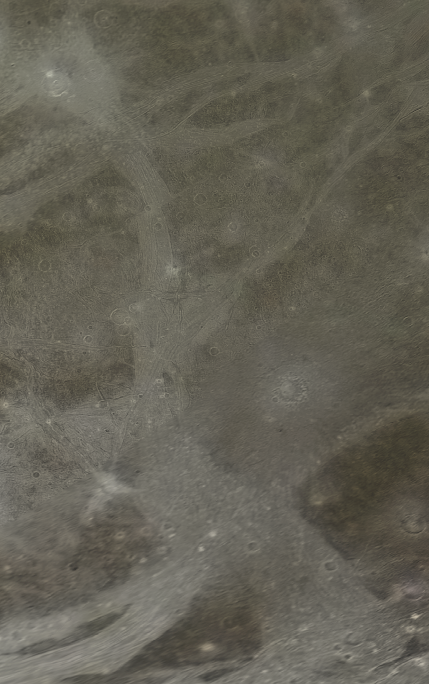
Dardanus Sulcus is a long, grooved trough on Jupiter’s moon Ganymede, stretching roughly 1,500 kilometers from north to south. Its surface is younger than the darker terrain around it. The feature is named after Dardanus, an ancient ruined city in modern-day Turkey. In Greek mythology, that city stood near the spot where Zeus, in the form of an eagle, abducted the Trojan prince Ganymede and took him to Mount Olympus. The International Astronomical Union approved the name in 1979, following the convention that Ganymede’s surface features are named after deities, heroes, or places from ancient Near Eastern myths, or figures and locations linked to Ganymede or Troy. Dardanus Sulcus falls into the latter group. On Earth, the Dardanelles Strait also takes its name from the same city. The sulcus cuts through two dark, ancient regions: Barnard Regio and Nicholson Regio, splitting each roughly into western and eastern lobes. It begins near the crater Danel in northern Barnard Regio and runs south. Along the way, it crosses another bright, grooved terrain called Mysia Sulci. After passing through that, it enters Nicholson Regio, where it again dissects the dark terrain. About five-sixths of the way along its path, it meets another bright sulcus, Arbela Sulci, near the crater Damkina. Dardanus Sulcus ends near the crater Nabu at the southern edge of Nicholson Regio. The sixth quadrangle of Ganymede is named after this sulcus (designated Jg6), but because of its length and the position of its northern end, more than half of it lies within the Nabu quadrangle (Jg11) to the south. The sulcus sits on the sub-Jovian hemisphere—the side of Ganymede that always faces Jupiter—so an observer there would see Jupiter fixed in the same spot in the sky. Like many bright regions on Ganymede, Dardanus Sulcus is a bright terrain with multiple sets of ridges and grooves. Scientists agree that bright terrains are younger than the darker, more rugged ones. They form when fresh water ice rises from beneath the surface, erasing and smoothing over the dark terrain. This fresh ice reflects sunlight well, making young terrains like Dardanus Sulcus much brighter than the surrounding dark regions, such as Nicholson Regio. This ongoing resurfacing through tectonic activity is common on Ganymede, shaping its appearance.
Quick Facts
- Length
- 1500 km
- Eponym
- Δάρδανος Dardanos
Facts from the source article.
Lore & Background
Dardanus Sulcus is named after the ancient city of Dardanus in modern-day Turkey, which in Greek mythology was near the site where the Trojan prince Ganymede was abducted by Zeus (the Greek equivalent of Jupiter) in the form of an eagle. The International Astronomical Union approved the name in 1979, following the convention that surface features on Ganymede be named after deities, heroes, and places from Ancient Near Eastern mythologies, or figures and places related to Ganymede or Troy. The Dardanelles Strait on Earth is also named after the same city. The sulcus runs across two dark, ancient regions: Barnard Regio and Nicholson Regio, cutting each roughly in half between their western lobes and eastern lobes.
Reader's Guide
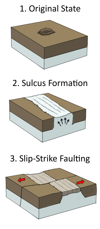
Dardanus Sulcus is significant as a key example of Ganymede's bright terrain, which is analogous to the Moon's dark maria in that both represent the youngest surfaces of their respective moons. While the Moon's young regions were shaped by basaltic lava, Ganymede's bright terrains were formed by upwelling water ice. The sulcus's formation and tectonic history have been studied by dividing it into eight morphological domains, revealing a sequence of crustal deformation: an ancient crust (Domain 1, heavily cratered dark terrain), intermediate light terrains (Domains 2–4) formed by east-northeast–west-southwest extension with a principal stress orientation of approximately 170°, and subsequent light terrains (Domains 5–8) that overprint earlier structures. A counterclockwise rotation of principal stresses to a northeast-southwest extensional regime produced a right-lateral offset of about 45 km along a northeast-southwest trending fault with a distinctive wavy planform. High-resolution images from the Galileo spacecraft revealed misaligned surface features indicative of strike-slip faulting and crustal deformation. Exploration began with Voyager 1 in July 1979, which imaged the entire sulcus. Galileo later provided high-resolution images but could not cover its full extent. As of 2026, Galileo's images remain the best available data. The Juno probe imaged Dardanus Sulcus during its 34th perijove in June 2021, with the feature near the southern limb. The upcoming Juice mission (launched April 2023, arriving July 2031) is expected to complete a high-resolution map of the sulcus.
Did You Know?
- Dardanus Sulcus runs for approximately 1,500 kilometres (930 mi) from north to south across Ganymede.
- The sulcus is named after the ancient city of Dardanus, near the site where Zeus abducted Ganymede in Greek mythology.
- Voyager 1 was the first probe to image Dardanus Sulcus in its entirety in July 1979.
- A northeast-southwest trending fault within the sulcus shows a right-lateral offset of approximately 45 km.
Structural Division of Nicholson Regio
Dardanus Sulcus serves as one of the two principal linear features that fragment Nicholson Regio, the vast dark region dominating the southern portion of Ganymede's Jupiter-facing hemisphere. Together with Arbela Sulcus, it carves the regio into three rough segments. While Arbela Sulcus slices diagonally from the southwest toward the northeast, Dardanus Sulcus takes a different trajectory, cutting from the north down toward the southeast. This particular orientation means it acts as the sharp dividing line between the western and eastern lobes of Nicholson Regio. The western lobe contains the darkest and likely oldest terrain, while the eastern lobe, though also rugged, displays a lighter coloration suggesting partial overwriting by newer material. The sulcus thus functions as a geological boundary, separating two distinct zones within what is considered the oldest surface on Ganymede. Its presence transforms what might otherwise be a continuous dark expanse into a clearly segmented landscape, each segment bearing its own character of roughness, cratering, and color variation.
Geological Youth and Brightness
Dardanus Sulcus stands in stark visual contrast to the ancient dark terrain it traverses. Where Nicholson Regio's surface is dominated by billions of years of accumulated tectonic buckling, fractures, and scarps, the sulcus appears younger and notably brighter. This brightness is not incidental; it reflects the broader geological narrative of Ganymede, where the earliest Nicholsonian Period saw the moon's originally bright icy surface become contaminated with dark non-ice material, and the subsequent Harpagian Period brought extensive resurfacing that largely erased those dark surfaces and replaced them with brighter coatings. Dardanus Sulcus belongs to this younger generation of grooved terrain that cuts across and interrupts the ancient dark regions. Its smooth, bright character makes it easily distinguishable in imagery from the rough, brownish-black plains of the western lobe or the groove-patterned eastern terrain. In essence, the sulcus is a visible record of Ganymede's later geological activity imposed upon its oldest crust.
Termination and Quadrangle Context
The southern terminus of Dardanus Sulcus marks a notable geographic point on Ganymede: the crater Nabu, which sits just south of Nicholson Regio where the sulcus ends. This placement anchors the feature within the moon's broader cartographic framework. Nicholson Regio, being so massive, spans four of Ganymede's designated quadrangles—Dardanus (Jg6), Misharu (Jg10), Nabu (Jg11), and Namtar (Jg14). Dardanus Sulcus, as the namesake feature of the Dardanus quadrangle, occupies a central position in this grid. The regio's location on the permanently Jupiter-facing hemisphere, a consequence of Ganymede's synchronous rotation, means that an observer standing along the sulcus would always have Jupiter fixed in the sky. The sulcus thus exists at the intersection of local geology and the moon's global orientation, threading through one of the most ancient and rugged landscapes on Ganymede while anchoring an entire mapping quadrangle.
Broader Geological Significance
Dardanus Sulcus is not merely a local groove; it is part of a moon-wide pattern of younger sulci terrain that has progressively fragmented Ganymede's oldest dark surfaces. The USGS identifies Nicholson Regio as the oldest surface feature on the moon, and features like Dardanus Sulcus represent the geological forces that have shaped, divided, and partially obscured that ancient terrain over billions of years. A 2020 study by Hirata, Suetsugu, and Ohtsuki proposed that the concentric furrow patterns in Ganymede's dark regions—including those in Nicholson Regio—may be remnants of a single colossal multi-ring basin created by a massive impact roughly four billion years ago. If confirmed, tectonic activity and the resurfacing by younger grooved terrains like Dardanus Sulcus would have been the agents that fragmented and obscured the original ring structure. The sulcus thus sits at the intersection of Ganymede's deepest past and its more recent geological chapters, a bright scar over an ancient wound.
Gallery
Frequently Asked Questions
What is Dardanus Sulcus?
It is a long, grooved trough on Ganymede, one of Jupiter's large moons, running roughly 1,500 kilometres from north to south. The feature sits on the sub-Jovian hemisphere and threads through two of Ganymede's mapped quadrangles, Jg6 and Jg11.
Why is it called Dardanus Sulcus?
The name honours Dardanus, an ancient ruined city in present-day Turkey. In Greek myth, that region is where Zeus—disguised as an eagle—carried off the Trojan prince Ganymede to Olympus, linking the moon's name to the city's.
How big is Dardanus Sulcus and which direction does it run?
The trough stretches approximately 1,500 kilometres (about 930 miles) and is oriented north to south. It crosses the Dardanus Sulcus quadrangle (Jg6) and the Nabu quadrangle (Jg11).
How does Dardanus Sulcus compare to the surrounding terrain on Ganymede?
It shows up as a long, bright band of grooved ground that contrasts sharply with the darker, older material on either side. Its surface is geologically younger than that surrounding dark terrain, pointing to later tectonic activity that reshaped that stretch of Ganymede's crust.
When was the name Dardanus Sulcus officially approved?
The International Astronomical Union ratified the designation in 1979. That followed the IAU's naming rule for Ganymede, which requires surface features to be drawn from deities, heroes, or places in ancient Near Eastern and Greek mythology.
More in Moons of Jupiter, Part 3 1-24
Spotted an error? Know more?
Reader corrections go straight into our review queue. Suggest an edit · How this site is sourced