
Bubastis Sulci
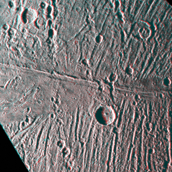
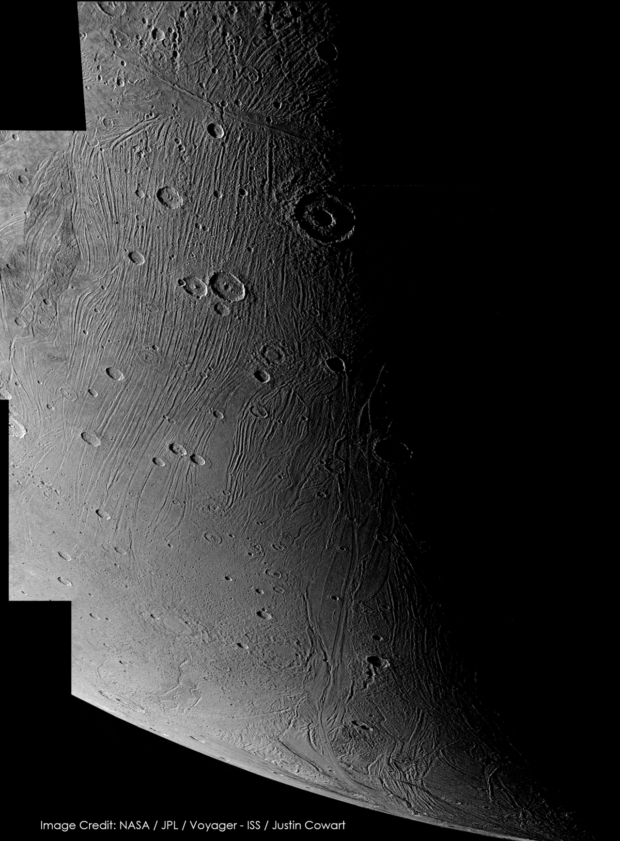
A bright, grooved terrain wrapping Ganymede's south pole.

NASA/JPL/ posted by Justin Cowart · Public domain
Bubastis Sulci is a sprawling, multi-sulci region that extends around the south pole of Jupiter's largest moon Ganymede. This surface feature runs for approximately 2730 km in some areas across the moon's surface. The International Astronomical Union (IAU) named Bubastis Sulci after the Ancient Egyptian town called Bubastis, a place that is famous for being the center of worship for Bastet, the great goddess of cats of the Ancient Egyptians. This is in line with the theme that features and craters on Ganymede should be named after deities, heroes, or places from Ancient Middle Eastern mythologies, which includes Egyptian mythology. The IAU approved the name for Bubastis Sulci in 1988. Bubastis Sulci is a massive feature that wraps around much of Ganymede's south pole. Bubastis Sulci is home to several impact craters of varying types like Anubis, Hathor, and Teshub. To its north lies the surface depression called Hamra Patera, and three bright craters that are close to each other—Isis, Osiris, and Ptah. To the northwest are the craters Nut and, further north, Tashmetum. To the north east is the crater Gilgamesh, one of the largest known impact craters on Ganymede. The sulci formation terminates near another sulcus, the Borsippa Sulcus, to the west. However, the endpoint of Bubastis Sulci to the east is unmarked by any geographical feature (abruptly ending at 120° west longitude). Bubastis Sulci occupies much of Ganymede's Hathor quadrangle (designated Jg15), although its northwesternmost parts are crossing over into Namtar quadrangle (designated Jg14)
Like many other bright regions on Ganymede, Bubastis Sulci is considered a typical example of bright, young terrain, characterized by multiple sets of ridges and grooves, smoother surfaces, and a lower crater density. Sulci like Bubastis mark the spots on Ganymede's surface where older, darker terrain had been erased and resurfaced with brighter, fresher materials (usually clean water ice) by endogenic tectonic forces. This process is common throughout Ganymede and has played a major role in shaping its appearance over the ages. Using stereographic imaging techniques, the space probe Voyager 2 was able to study the topography of Bubastis Sulci because it was where its best stereo imaging was concentrated, allowing scientists to search for evidence of extrusion associated with the bright terrain.
Quick Facts
- Length
- 2730 km
- Eponym
- Bubastis
Facts from the source article.
Lore & Background
Bubastis Sulci is a massive feature that wraps around much of Ganymede's south pole. It is home to several impact craters of varying types, including Anubis, Hathor, and Teshub. To its north lies the surface depression called Hamra Patera, and three bright craters close to each other—Isis, Osiris, and Ptah. To the northwest are the craters Nut and, further north, Tashmetum. To the northeast is the crater Gilgamesh, one of the largest known impact craters on Ganymede. The sulci formation terminates near another sulcus, Borsippa Sulcus, to the west, while its eastern endpoint is unmarked by any geographical feature, abruptly ending at 120° west longitude. Like many other bright regions on Ganymede, Bubastis Sulci is considered a typical example of bright, young terrain, characterized by multiple sets of ridges and grooves, smoother surfaces, and a lower crater density. Sulci like Bubastis mark spots where older, darker terrain had been erased and resurfaced with brighter, fresher materials (usually clean water ice) by endogenic tectonic forces. Using stereographic imaging, the space probe Voyager 2 studied the topography of Bubastis Sulci, as it was where its best stereo imaging was concentrated. An unusual exposure of bright terrain occurs at 77°S, 145°W, in the form of a linear ridge at least 500 km long, flanked by smooth material extending laterally up to 50 km. This ridge cuts across Bubastis Sulci and is the only structure observed to do so, making it a unique feature.
Reader's Guide
Bubastis Sulci holds significance as a key site for understanding Ganymede's tectonic history and resurfacing processes. The Voyager 2 probe's stereographic images of this region were used by scientists to study the nature of Ganymede's tectonic activity and the moon's history, as the area provided the best stereo imaging data. The ridge and surrounding smooth deposits lie in a broad, shallow depression, with the ridge itself being discontinuous and showing substantial variations in height and width. Its northern end tapers gradually into smooth deposits, and sections of the ridge double, suggesting underlying structural features guided its formation. Additional parallel, discontinuous ridges within the smooth terrain appear to be partially flooded remnants of ridge-and-trough formations. These observations support the interpretation that the smooth deposits originated from the extrusion of a fluid-like material. The deposits follow the topography closely and embay the grooves of Bubastis Sulci, similar to how lunar maria embay craters, indicating that the smooth deposits are younger than the grooved terrain. The region's location around the south pole makes it difficult to observe from spacecraft flying along the ecliptic plane, as Jupiter's rotational axis and Ganymede's orbit are tilted by only about 3.1° with respect to Jupiter's orbital plane. Voyager 2 managed to send back the first clear images at low angles due to its slightly southward trajectory, and Galileo became the next and last spacecraft to date to see Bubastis Sulci.
Did You Know?
- Bubastis Sulci runs for approximately 2,730 kilometers (1,700 miles) across Ganymede's surface.
- The feature is named after the Ancient Egyptian town of Bubastis, center of worship for the cat goddess Bastet.
- A unique linear ridge at least 500 km long cuts across Bubastis Sulci, flanked by smooth material extending up to 50 km laterally.
- Voyager 2's stereographic images of Bubastis Sulci were used to study Ganymede's tectonic activity and history.
Geology and the Birth of a Bright Scar
Ptah is a relatively modest impact crater measuring roughly thirty kilometres across, yet it stands out as one of the most luminous features visible on Ganymede's surface. The asteroid or comet responsible for carving it struck what geologists classify as a regio, a dark ancient expanse representing some of the oldest terrain on the moon. That collision blasted away a portion of the aged shadowed ground and hurled fresher, brighter material, most likely clean water ice, from deeper layers outward in every direction. The secondary fragments scattered so uniformly that the resulting ray system appears strikingly symmetrical, radiating like spokes from a wheel. Because the newly exposed ice is far more reflective than the surrounding dark weathered terrain, the rays glow with an intensity that makes the crater one of the brightest landmarks on the entire moon. Despite its small size, Ptah is considered young-looking, a vivid reminder that Ganymede's surface is still being reshaped by cosmic impacts.
A Name Drawn from Ancient Egyptian Myth
Ptah's designation honours one of the most significant deities in the ancient Egyptian pantheon. In the city of Memphis, which served as one of Egypt's greatest capitals for centuries, Ptah was revered as the sovereign and chief god. Certain ancient traditions held that he spoke the universe into existence and went on to create every other deity. His consort was Sekhmet, a fierce lion-headed goddess associated with war, and their son Nefertem embodied beauty and the fragrance of perfumes. Over time, Ptah's identity also evolved to encompass patronage of craftsmen and the arts, a natural extension of his role as a creative force. The International Astronomical Union's naming convention for Ganymede requires that craters and other surface features draw their names from deities, heroes, and places in Ancient Middle Eastern mythologies, with Egyptian tradition included. Neighbouring craters such as Anubis and Osiris follow the same pattern. The IAU formally approved the name Ptah in 1988.
Position in the Southern Dark
Ptah sits in Ganymede's southern hemisphere, positioned just over two-thirds of the way from the equator down toward the south pole. It falls within the Hathor quadrangle, designated Jg15, the mapping region that encircles the moon's southern polar area. To the crater's east lies Isis, a larger and equally bright impact feature, while a cluster of unnamed smaller craters crowds around Ptah, partially obscuring sections of its otherwise symmetrical ray pattern. Stretching southward from the crater's rim, the vast grooved terrain of Bubastis Sulci spreads across the surface all the way toward the south pole, creating a dramatic linear landscape adjacent to the crater. Because Ganymede is tidally locked to Jupiter, the hemisphere containing Ptah perpetually turns away from the gas giant. An observer standing at the crater's edge would never glimpse Jupiter hanging in the sky above, a permanent absence that underscores the moon's rigid orbital relationship with its parent planet.
From Voyager's Glimpse to JUICE's Detailed Survey
The sole spacecraft to have captured images of Ptah was Voyager 2, which flew past Jupiter and Ganymede in July 1979. The crater's proximity to the south pole makes it extremely difficult to observe from spacecraft travelling along the Solar System's ecliptic plane. Voyager 2's trajectory, angled slightly southward as it headed toward Saturn, happened to provide the ideal vantage point for photographing Ganymede's polar region, yielding the first-ever pictures of the crater. For decades those images remained the only visual record. That will change with the European Space Agency's Jupiter Icy Moons Explorer, launched in April 2023 and expected to reach Jupiter in July 2031. After roughly three and a half years of orbiting Jupiter and conducting flybys of Europa, Callisto, and Ganymede, JUICE will settle into a low polar orbit around Ganymede. From that vantage, the probe will repeatedly image the moon's poles at high resolution, and Ptah is expected to fall well within its survey coverage.
Gallery
Frequently Asked Questions
What is Bubastis Sulci?
Bubastis Sulci is a sprawling system of bright, grooved terrain on Ganymede, Jupiter's largest moon. It consists of multiple parallel sulci (grooves) that form a broad band across the lunar surface.
Where is Bubastis Sulci located on Ganymede?
The feature wraps around Ganymede's south polar region, sitting primarily within the Hathor quadrangle (Jg15). Its northwestern portions spill over into the adjacent Namtar quadrangle (Jg14).
How long is Bubastis Sulci?
In its longest stretches, the grooved terrain spans approximately 2,730 kilometers, or roughly 1,700 miles, across Ganymede's surface.
Why is it called Bubastis Sulci?
The IAU named it after the ancient Egyptian city of Bubastis, which served as the chief center of worship for Bastet, the cat goddess. This follows Ganymede's established convention of borrowing names from Ancient Middle Eastern mythological figures and places.
When was the name Bubastis Sulci officially approved?
The International Astronomical Union ratified the designation in 1988, locking it into Ganymede's official surface nomenclature.
More in Moons of Jupiter, Part 3 1-24
Spotted an error? Know more?
Reader corrections go straight into our review queue. Suggest an edit · How this site is sourced