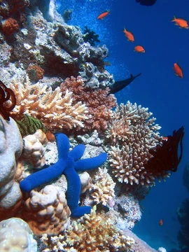
Catlin Seaview Survey
Expedition documenting global coral reef composition and health.

The Catlin Seaview Survey, later renamed the XL Catlin Seaview Survey, was a major scientific expedition that began in September 2012. Its aim was to document the composition and health of coral reefs worldwide by carrying out a rapid assessment of the current state of coral reef systems and making the scientific record publicly available for scientists globally.
- Start date
- September 2012
- Initial focus
- Great Barrier Reef
- Reefs sampled initial
- 32
- Distance surveyed initial
- 150 kilometers (93 miles)
- Images produced initial
- approximately 105,000
- Deepest reef discovered depth
- 125 meters (410 feet)
- Global record launch year
- 2013
Lore & Background
The survey started in September 2012, focusing on sections of the Great Barrier Reef across a range of depths. Thirty-two reefs were sampled, equating to approximately 150 kilometers of reef, producing around 105,000 images now analyzed globally using image recognition software. This initial work also led to the discovery of the deepest known coral reef in the Great Barrier Reef, at a depth of 125 meters. In 2013, the survey expanded to sample corals in the Caribbean Sea and Bermuda, with other sites explored in 2014. The survey was sponsored by the Catlin Group until the sponsorship ended, concluding the survey. The original team created a film, 'Chasing Coral,' and a new global initiative known as '50 Reefs.'
Reader's Guide
The Catlin Seaview Survey is notable for creating a comprehensive visual record of the world's reefs using high-resolution, 360-degree panoramic imagery. These images are GPS-tagged with camera direction, allowing precise location documentation and enabling visual comparison of different reefs and monitoring of individual reefs over time. The imaging aims to help the general public and policy makers identify threats to coral reefs and assist in forming protection strategies. Data from the survey was used to construct the Catlin Global Reef Record, launched in 2013, which contains images and data from the survey and other research. This record is freely available to scientists globally for analyzing reef environments and monitoring change. The survey also utilized specialist divers, remotely operated underwater vehicles (ROUVs) for deeper reefs, and Pulsed Amplitude Modulated (PAM) stress detection devices to monitor stress levels in deeper reefs. Biological samples were collected to identify potential genetic links between shallow and deep coral systems, important for conservation.
Did You Know?
- The SVII camera used was a self-propelling underwater panoramic camera designed by the survey team.
- The Catlin Global Reef Record was launched in 2013 and is freely available to scientists worldwide.
- The survey produced approximately 105,000 images from the initial Great Barrier Reef sampling.
Frequently Asked Questions
What is the Catlin Seaview Survey?
The Catlin Seaview Survey (later rebranded as the XL Catlin Seaview Survey) is a large-scale scientific expedition that set sail in September 2012 with the goal of cataloguing the condition of coral reefs around the world. It was designed as a rapid, comprehensive assessment of reef health rather than a single-site study.
What role does the Catlin Seaview Survey play in reef science?
Its core function is to produce a publicly accessible scientific record of coral reef composition and vitality so that researchers anywhere can draw on the data. By standardizing its survey methodology across multiple reef systems, it gives the global scientific community a shared baseline to track change over time.
Where did the Catlin Seaview Survey begin its work and how much data did it generate at the start?
The expedition kicked off at the Great Barrier Reef, where it initially surveyed 32 individual reefs spread across roughly 150 kilometers (about 93 miles) of coastline. That starting stretch produced approximately 105,000 images of reef structure and biodiversity.
How deep did the Catlin Seaview Survey document living coral?
During its initial phase the team recorded healthy reef communities at a depth of 125 meters (around 410 feet), pushing the known limits of where viable coral assemblages exist in that region.
Why is the Catlin Seaview Survey important to the broader reef community?
Because it committed to releasing its findings openly, it removed the access barriers that often keep reef data locked inside single institutions. That open-data approach means a graduate student in one country and a marine manager in another can both reference the same baseline measurements.
More in Coral Reefs 1-24
Spotted an error? Know more?
Reader corrections go straight into our review queue. Suggest an edit · How this site is sourced