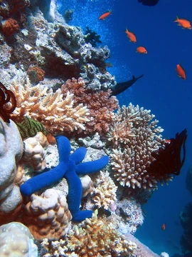
Apo Reef
World's second-largest contiguous coral reef system, in the Philippines.

Here is the rewritten encyclopedia entry about Apo Reef.
Apo Reef is a massive coral formation in the Philippines, found in the Mindoro Strait off the western coast of Occidental Mindoro. Spanning 34 square kilometers, it ranks as the second-largest contiguous coral reef system on Earth and the largest within the country. The reef and the waters around it are safeguarded as the Apo Reef Natural Park, and the site is on the tentative list for UNESCO World Heritage recognition.
The reef lies roughly 28 kilometers west of Mindoro Island, separated from it by the Apo East Pass. Politically, it falls under the jurisdiction of the Municipality of Sablayan in Occidental Mindoro. The park is also recognized as an Important Bird Area by BirdLife International, supporting a significant seabird population with at least 10,000 recorded breeding pairs.
The reef itself is a roughly triangular atoll-like formation, stretching about 26 kilometers from north to south and 20 kilometers from east to west. It is divided into northern and southern lagoon systems, separated by a deep channel open to the west. The north lagoon is a shallow, enclosed triangular platform that partly emerges at low tide, with depths of 2 to 10 meters. The south lagoon is an inverted triangular platform, enclosed on two sides, reaching depths of about 30 meters. The modern reef grew over an older formation during the last glacial cycle, roughly 19,000 years ago, shaped by fluctuating sea levels and the subsidence of the crust toward the Manila Trench.
Three small, uninhabited islands mark the reef's surface. The largest, Apo Island, covers 22 hectares and features mangroves and beach vegetation. It houses a permanent ranger base and an administrative desk for environmental fees; overnight camping is allowed under certain conditions, though facilities are minimal to protect the ecosystem. Apo Menor (locally Binangaan) is a rocky limestone islet about 3 kilometers east of Apo Island, with sparse vegetation. Cayos del Bajo (locally Tinangkapan) are flat coralline rock formations with no vegetation, located on the northern lagoon near the eastern edge of the reef; at low tide, many small rocks become exposed along the northern side.
Quick Facts
- Iucn Category
- II
- Location
- Mindoro Strait, Philippines
- Nearest City
- Sablayan
- Area
- 34 km2
- Governing Body
- Department of Environment and Natural Resources / Municipal Government of Sablayan
Facts from the source article.
Lore & Background
Apo Reef is a roughly triangular coral atoll formation, approximately 26 km from north to south and 20 km from east to west. It is separated by two lagoon systems—the north and south lagoons—bounded by narrow reef platforms. The reef consists of almost triangular northern and southern atoll-like reefs separated by a deep channel open to the west, with depths ranging from 1.8 to 30 meters. The north lagoon is relatively shallow at 2–10 meters, while the south lagoon reaches about 30 meters in depth. Studies indicate the modern reef grew over an old reef formation during the last glacial cycle approximately 19,000 years ago, with its surface morphology shaped by fluctuating sea levels as the crust subsides toward the Manila Trench.
Three uninhabited islands mark the reef: Apo Island (the largest, at 22 hectares, with mangroves and beach vegetation), Apo Menor (a rocky limestone islet with little vegetation), and Cayos del Bajo (flat coralline rock formations with no vegetation). Apo Island houses a permanent ranger base and an administrative desk for environmental fees. The Apo Reef Light, situated on the northeast part of the island, warns ships of the navigational hazard. Since the declaration of a no-take-zone policy in 2007, only protected area personnel and members of Task Force MARLEN stay in the park on weekly shifts.
Reader's Guide
Apo Reef was first officially declared a Marine Park by Philippine president Ferdinand Marcos in 1980, followed by the local government of Sablayan declaring it a Tourism Zone and Marine Reserve three years later. In 1996, president Fidel Ramos declared the entire reef a protected natural park. In 2006, the Protected Areas and Wildlife Bureau submitted the reef to the UNESCO World Heritage Centre for consideration. Following a survey by the World Wide Fund for Nature, fishing within the reef was banned in September 2007, and the marine park opened for tourists to generate funds for protection and provide alternative livelihoods for fishermen. The reef was declared a national park under Republic Act No. 11038, signed by President Rodrigo Duterte in July 2018. The park has been designated an Important Bird Area by BirdLife International, supporting at least 10,000 breeding pairs of seabirds. Scuba diving and snorkeling are exceptional due to the quality of flora, fauna, water clarity, and white sand, with species including sharks, giant napoleons, and manta rays.
Did You Know?
- Apo Reef is the largest contiguous coral reef system in the Philippines.
- The reef is separated from Mindoro by the Apo East Pass of the Mindoro Strait.
- Apo Island, the largest island on the reef, covers 22 hectares.
- The park supports at least 10,000 breeding pairs of seabirds, earning it an Important Bird Area designation.
Geography & Physical Structure
Apo Reef presents as a roughly triangular coral atoll stretching approximately 26 kilometers from its northern tip to the southern one, and 20 kilometers across its east-west axis. This 34-square-kilometer formation sits roughly 28 kilometers west of the Mindoro coastline, separated from the main island by the Apo East Pass within the Mindoro Strait. The reef is divided into two distinct lagoon systems: the north lagoon, an enclosed triangular platform that is relatively shallow at 2 to 10 meters and partly exposed during low tide, and the south lagoon, an inverted triangular platform enclosed on two sides reaching about 30 meters in depth. A deep channel, open to the west, runs between them with depths ranging from 1.8 to 30 meters over a fine white sand bottom dotted with mounds and patches of branching coral. Three small, uninhabited islands break the surface—Apo Island with its mangroves, the rocky limestone Apo Menor, and the flat coralline rocks of Cayos del Bajo. Scientific evidence suggests the modern reef grew atop an older formation dating to roughly 19,000 years ago, shaped by fluctuating sea levels as the crust subsides toward the Manila Trench.
Conservation & Protection History
The journey of Apo Reef from open fishing grounds to a protected national park spans nearly four decades of escalating legal safeguards. In 1980, President Ferdinand Marcos first designated the reef as a Marine Park. Three years later, the local government of Sablayan reinforced this by declaring the area a Tourism Zone and Marine Reserve. A major leap came in 1996 when President Fidel Ramos elevated the entire reef to a protected natural park. In 2006, the Protected Areas and Wildlife Bureau submitted the site to UNESCO for World Heritage consideration, and it now appears on the tentative list. A turning point arrived in September 2007, when a World Wide Fund for Nature survey prompted the government to ban all fishing within the reef and establish a no-take-zone policy. To offset the economic impact on local fishermen, the marine park opened to tourists, generating revenue for conservation while offering an alternative livelihood. The framework was further solidified in July 2018, when President Rodrigo Duterte signed Republic Act No. 11038, enshrining Apo Reef as a national park. The total protected area now covers 274.69 square kilometers, comprising 157.92 square kilometers of core park and 116.77 square kilometers of surrounding buffer zone.
Biodiversity & Ecosystem
BirdLife International has designated Apo Reef as an Important Bird Area, a distinction earned by the presence of at least 10,000 breeding seabird pairs that nest within the park's boundaries. Beneath the surface, the reef's ecological richness is equally striking. The deep western channel reveals a fine white sand floor scattered with mounds and patches of branching coral suspended in deep blue water, while the eastern and southeastern flanks are underlain by reef limestone and coralline sand. Apo Island itself supports mangrove forests along its eastern and southern shores, with soil ranging from sandy to sandy loam outside the lagoonal zones and sandy loam to clay loam beneath the mangroves, underlain by decomposed plant residues or coarse materials. The reef surrounding the island extends up to one kilometer in places. The overall quality of the flora, fauna, and water clarity makes the underwater environment exceptional, and the modern reef structure itself is a product of roughly 19,000 years of growth over an older formation, shaped by the slow subsidence of the crust toward the Manila Trench.
Access, Tourism & Daily Operations
Reaching Apo Reef requires a two-and-a-half-hour pump boat journey heading 240 degrees from Sablayan, the nearest municipal port. Upon arrival, visitors must pay an environmental fee administered jointly by the local government of Sablayan and the Department of Environment and Natural Resources. The main draw for visitors is the underwater experience: scuba diving and snorkeling are considered exceptional owing to the quality of the flora, the richness of the fauna, and the clarity of the water. Onshore, facilities are deliberately minimal to protect the fragile ecosystem. A permanent ranger base on Apo Island monitors the national park, and an administrative desk collects the required fees. Overnight stays in tents are permitted subject to certain conditions, but no permanent structures exist beyond these limited provisions. Since the 2007 no-take-zone declaration, the three islands remain uninhabited by residents; only protected-area personnel and members of Task Force MARLEN, the Marine and Apo Reef Law Enforcement for Nature unit, are stationed there on weekly shifts to carry out conservation duties. A lighthouse on the island's northeastern tip warns passing vessels of the navigational hazard below.
More in Coral Reefs 1-24
Spotted an error? Know more?
Reader corrections go straight into our review queue. Suggest an edit · How this site is sourced