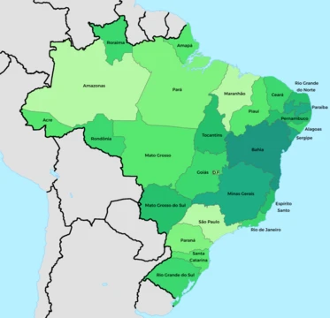
North Region, Brazil
Largest Brazilian region, home to the Amazon Rainforest.

via Wikipedia: North Region, Brazil · see source
The North Region of Brazil covers nearly half the country—45.27% of the national territory—making it the largest region, though it has the second-lowest population and the lowest population density, at just 4.5 people per square kilometer. It is slightly larger than India and slightly smaller than the European Union. The region includes the states of Acre, Amapá, Amazonas, Pará, Rondônia, Roraima, and Tocantins. Most residents live in urban areas. Belém International Airport and Manaus International Airport connect the region to many Brazilian cities and offer some international flights. The Federal University of Amazonas and the Federal University of Pará are among its higher education institutions.
The first inhabitants were Native Brazilians, with diverse tribes and villages from pre-Columbian times until European arrival. Spanish explorers, including Francisco de Orellana, led expeditions along the Amazon River. After traveling with Orellana, Gonzalo Fernández de Oviedo y Valdés wrote to Cardinal Pedro Bembo in Venice, praising the region’s fauna and flora. In the 17th century, the Portuguese arrived, building military forts in 1616 to defend against invasions, which led to the founding of Belém do Pará. The Amazon Rainforest’s riches attracted the Portuguese Crown, and Catholic missionaries came to convert the indigenous people, gathering them into villages called missions—many of which became cities like Borba and Óbidos. Some of the region’s oldest towns include Bragança, Xapuri, Tefé, Natividade, and Amapá. Workers from other Brazilian states, mainly the Northeast, moved here for rubber extraction, and Japanese families came for agricultural colonies. During the 1960s, 1970s, and 1980s, military governments launched a major integration plan, building highways like BR-010, setting up industries, and creating the Free Economic Zone of Manaus.
Territorial borders do not always match indigenous occupation; many people live on both sides of international boundaries created long after they settled. From the 17th century onward, inhabitants engaged in extractive and mercantilist activities, with a rubber monopoly from 1840 to 1910, especially in Amazonas and Acre. Colonization reduced the indigenous population, increased the Caboclo identity (a mix of whites, blacks, and indigenous people), and diminished plant and animal species. After World War II, the Brazilian Amazon became part of national development. The National Institute of Amazonian Research (INPA) was created in 1952, followed by the Superintendency of Development for the Amazon (SUDAM) in 1966 and the Free Economic Zone of Manaus in 1967, which helped settle the region and run local projects.
The Amazon holds over half the world’s remaining rainforests and is the largest, most species-rich tropical rainforest. Wet tropical forests are the most biodiverse biome, and those in the Americas are richer than in Africa or Asia. More than a third of all species on Earth live in the Amazon. The region hosts about 2.5 million insect species, tens of thousands of plants, and around 2,000 bird and mammal species. Scientifically classified species include at least 40,000 plants, 3,000 fish, 1,294 birds, 427 mammals, 428 amphibians, and 378 reptiles. In Brazil alone, scientists have described between 96,660 and 128,843 invertebrate species. Plant diversity is the highest on Earth—one square kilometer may contain over 75,000 tree types and 150,000 higher plant species, with about 90,790 tonnes of living plants. One in five of the world’s bird species lives in the Amazon. To date, 438,000 plant species of economic or social interest have been registered, with many more undiscovered. Some latitudes produce hot, humid climates; heat and abundant water drive evaporation, making the region very humid. The equatorial climate brings high temperatures year-round (averaging 24 °C to 26 °C) and low thermal variation, except in parts of Amazonas, Rondônia, and Acre, where a “friagem” occurs due to La Niña, allowing cold air from the South Atlantic to penetrate from southern Brazil.
- area_percentage_of_Brazil
- 45.27%
- population_density
- 4.5 inhabitants per km²
- states
- Acre, Amapá, Amazonas, Pará, Rondônia, Roraima, Tocantins
- climate
- Equatorial, with averages from 24°C to 26°C
- major_cities
- Belém, Manaus
- key_economic_activities
- Vegetal extraction (latex, açaí, woods, Brazil nuts), mineral extraction (gold,
Verified Timeline
Lore & Background
The first inhabitants of the North Region were Native Brazilians, who lived in diverse tribes and villages from the pre-Columbian period until the arrival of Europeans. Spanish explorers, including Francisco de Orellana, organized expeditions along the Amazon River. After long journeys alongside Orellana, Gonzalo Fernández de Oviedo y Valdés wrote a letter to Cardinal Pedro Bembo in Venice, extolling the region's fauna and flora. In the 17th century, the Portuguese arrived, building military strongholds to defend the region against invasion, and in 1616 founded Belém do Pará. Catholic missionaries came to catechize the natives, gathering them into villages called missions, which later gave rise to cities such as Borba and Óbidos. During the 1960s, 1970s, and 1980s, military governments implemented a major plan to integrate the region, including construction of highways like the BR-010, installation of industries, and creation of the Free Economic Zone of Manaus.
Reader's Guide
The North Region of Brazil is significant for its immense size and ecological importance. It contains the Amazon Rainforest, which holds unparalleled biodiversity: over one-third of all species in the world live there, including at least 40,000 plant species, 3,000 fish, 1,294 birds, and 427 mammals. One square kilometre may contain over 75,000 types of trees and 150,000 species of higher plants. The region's economy relies on vegetal extraction (latex, açaí, woods, Brazil nuts) and mineral extraction (gold, precious stones, cassiterite, tin), as well as mining of iron at Carajás Mountain Range and manganese at Navio Mountain Range, plus the Free Economic Zone of Manaus. Culturally, it features distinctive folklore such as the Parintins Folklore Festival, Círio de Nazaré in Belém, and typical dances like Marujada and Carimbó. The gastronomy has Indigenous, African, and Portuguese roots, with dishes like duck in tucupi sauce, maniçoba, and tacacá, and fruits such as açaí, pupunha, and cupuaçu. The region's history includes early indigenous habitation, Spanish and Portuguese exploration, missionary settlement, rubber extraction from 1840 to 1910, and modern development projects. Its low population density and high biodiversity make it a critical area for global environmental conservation.
Did You Know?
- The North Region accounts for 45.27% of Brazil's national territory and is slightly larger than India.
- One square kilometre of Amazon rainforest can contain about 90,790 tonnes of living plants.
- The region has the lowest population density in Brazil, with only 4.5 inhabitants per km².
- The 'friagem' phenomenon, caused by La Niña, can bring cold air masses from the South Atlantic to parts of Amazonas, Rondônia, and Acre.
- The Parintins Folklore Festival and Círio de Nazaré in Belém are major cultural attractions in the region.
More in Brazilian States 1-24
Related in Brazilian States
Links follow this subject's own source article.
Spotted an error? Know more?
This is a living reference — every entry is fact-audited, and reader corrections feed straight into our audit queue. Suggest an edit · See this site's audit record