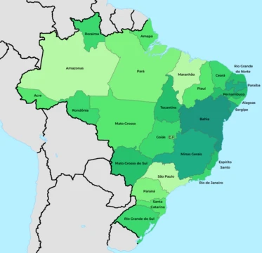
Mato Grosso do Sul

Mato Grosso do Sul is one of Brazil's 27 federal units, situated in the southern part of the Central-West Region. It shares borders with five Brazilian states—Mato Grosso to the north, Goiás and Minas Gerais to the northeast, São Paulo to the east, and Paraná to the southeast—as well as two South American countries: Paraguay to the south and southwest, and Bolivia to the west. The state covers an area of 357,145.532 square kilometers, roughly the size of Germany, and is divided into 79 municipalities. Its capital and largest city is Campo Grande. With a population of about 2.95 million as of 2026, it is the 21st most populous state in Brazil, accounting for 1.3% of the national population and contributing 1.5% of Brazil’s GDP. The economy relies heavily on agriculture and cattle ranching. The Tropic of Capricorn crosses the southern part of the state, giving it a generally warm, humid climate, and it is crisscrossed by many tributaries of the Paraná River. Mato Grosso do Sul is a destination for both domestic and international tourism, largely due to its natural environment. The Pantanal lowlands span 12 municipalities, featuring forests, sand banks, savannahs, open pasture, and bushes, while the city of Bonito, located in the Bodoquena mountains, offers prehistoric caves, natural rivers, waterfalls, swimming pools, and the Gruta do Lago Azul cave. The state’s name means "Southern Thick Bush" in Portuguese, inherited from its northern neighbor Mato Grosso, from which it was split on 11 October 1977, with full statehood achieved on 1 January 1979. Other proposed names included Pantanal and Maracaju. The region was historically home to the Guarani-Kaiowá people, first contacted by non-indigenous peoples in the 1800s, and earlier saw short-lived Jesuit missions among the Guaraní in the 1630s, destroyed by Bandeirantes and indigenous revolts.
- Capital
- Campo Grande
- Number of Municipalities
- 79
- GDP Share of Brazil
- 1.5%
- Largest City
- Campo Grande
Lore & Background
The new state also incorporated the former territory of Ponta Porã. Its name is Portuguese for 'Southern Thick Bush,' inherited from its northern neighbor. Other proposed names included 'Pantanal' and 'Maracaju.' The state is consistently referred to by its full name or the abbreviation 'MS'; calling it 'Mato Grosso' would be incorrect as that refers to a different state. The state's history includes Jesuit missions among the Guaraní people in the 1630s, which were destroyed by Bandeirantes and indigenous revolts. The Guarani-Kaiowá people, first contacted by non-indigenous peoples in the 1600s and 1700s through Jesuit missions and bandeirantes, are among the indigenous groups of the region. The state's vegetation is dominated by the Pantanal and cerrado ecosystems, with the cerrado characterized by savanna formations and gallery forests. The Pantanal biome has suffered from increasingly damaging forest fires due to land clearing and drier conditions from climate change.
Reader's Guide
Mato Grosso do Sul is significant as a major agricultural and livestock producer in Brazil. It is the 5th biggest grain producer in the country, a leading producer of soybeans, sugarcane, and maize, and holds the 4th largest cattle herd in Brazil. The state's economy is also supported by industry, particularly pulp and paper production in Três Lagoas, and mining of iron and manganese. Its natural environment, especially the Pantanal lowlands and the city of Bonito with its caves and rivers, makes it a destination for domestic and international tourism. The state has 1.3% of Brazil's population but contributes 1.5% of the national GDP. Its creation in the late 1970s marked a significant administrative division, and its demographic composition includes a mix of White, Brown (Multiracial), Black, Amerindian, and Asian populations, with European ancestry predominant according to DNA studies.
Did You Know?
- Mato Grosso do Sul is about the same size as Germany.
- The Pantanal lowlands cover 12 municipalities and present a variety of flora and fauna.
Geography & Natural Wonders
Its borders touch five neighboring states and two sovereign nations—Paraguay to the south and Bolivia to the west—making it a true crossroads of South America. The Tropic of Capricorn slices through the state's southern reaches, and its climate oscillates between humid subtropical and tropical patterns, with January peaks near 34 degrees Celsius and July lows that can dip to minus 2 degrees. The state's most celebrated natural feature is the Pantanal, a vast lowland biome spanning twelve municipalities and offering a mosaic of forests, natural sand banks, savannahs, open pastures, and scrubland. In the Bodoquena mountain range, the town of Bonito reveals prehistoric caves, crystal-clear rivers, waterfalls, and the famous Gruta do Lago Azul. Meanwhile, the cerrado ecosystem dominates much of the interior, its twisted-trunked, thick-barked trees and deep-rooted herbaceous plants evolved to survive the periodic fires that sweep the landscape.
Origins, Indigenous Roots & the Road to Statehood
The human story of this region stretches back millennia. The Guarani-Kaiowá were among the earliest peoples to inhabit the Nhande Ru Marangatu tropical rainforests, and they were not contacted by non-indigenous outsiders until the nineteenth century. In the 1630s, Jesuit missionaries attempted to establish short-lived missions among the Guaraní in the Itatín area, but these settlements were destroyed by Bandeirantes raiders and by indigenous uprisings. For much of its existence, this territory was simply the southern portion of the larger state of Mato Grosso. The new state inherited the name "Mato Grosso do Sul"—literally "Southern Thick Bush"—from its northern neighbor, and in everyday speech many residents still shorten it to just "Mato Grosso." During the separation debate, alternative names such as "Pantanal," after the region's iconic wetlands, and "Maracaju," referencing the mountain range that runs north to south through the state, were also proposed.
A Mosaic of Peoples
Its capital and largest city, Campo Grande, anchors a network of 79 municipalities spread across a vast, sparsely settled landscape with a density of just over six people per square kilometer. Ethnically, the state is remarkably blended. Census data show nearly 47 percent of inhabitants identifying as multiracial, about 42 percent as white, roughly 6.5 percent as Black, 3.5 percent as indigenous, and under 1 percent as Asian. In the cerrado regions of the south, central, and east, farming communities trace their roots to Spanish, German, Portuguese, Italian, and Slavic settlers from southern Brazil.
Economy, Education & the Environmental Crossroads
Agriculture and cattle-raising form the economic backbone of Mato Grosso do Sul, though the service sector now accounts for the largest share of GDP at 46.1 percent. The state contributes 1.5 percent of Brazil's total economic output and draws both domestic and international tourists to its natural attractions. Education infrastructure is substantial, with more than forty-four universities operating across the state, including the Federal University of Mato Grosso do Sul, the State University, the Federal University of the Dourados Region, Dom Bosco Catholic University, and the University for the Development of the State and Region of the Pantanal. Yet the very industries that drive growth are reshaping the landscape. The Pantanal biome faces an escalating threat from increasingly destructive wildfires, a consequence of expanding fire-based land clearing compounded by drier conditions linked to climate change. The state thus stands at a crossroads between economic expansion and the preservation of one of South America's most biodiverse ecosystems.
More in Brazilian States 1-24
Spotted an error? Know more?
This is a living reference — every entry is fact-audited, and reader corrections feed straight into our audit queue. Suggest an edit · See this site's audit record