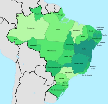
Maranhão
A Brazilian state with a UNESCO capital and rich ecosystems.

Maranhão is a state in Brazil’s Northeast Region, covering about 332,000 square kilometers and home to roughly 7 million people across 217 municipalities. Its northern border meets the Atlantic Ocean along a 2,243-kilometer coastline, while it shares land borders with Piauí, Tocantins, and Pará. The state’s people speak a distinctive dialect among Northeastern Brazilian Portuguese varieties. Maranhão appears in notable literary works, including Gonçalves Dias’s *Exile Song* and Aluísio Azevedo’s *Casa de Pensão*. The capital, São Luís, is a UNESCO World Heritage Site. Important conservation areas include the Lençóis dunes and the Parnaíba River Delta, shared with Piauí, which features lagoons, sand dunes, and uninhabited islands like Caju Island, a habitat for rare birds.
Geographically, northern Maranhão is a forested plain crossed by many rivers, part of the Amazonian tropical moist forests. The Tocantins–Araguaia–Maranhão moist forests occupy the northwest, while the north-central and northeast host the Maranhão Babaçu forests, dominated by the Babaçu palm, whose oil is used for food and beauty products. The south lies in the lower terraces of the Brazilian Highlands, covered by Cerrado savannas, with escarpments like the Chapada das Mangabeiras marking river valleys. The climate is hot, with a wet and dry season; coastal humidity is moderated by southeast trade winds. All rivers flow north to the Atlantic; major ones include the Gurupí, Tocantins, Parnaíba, Mearim, Pindaré, Grajaú, Itapecuru, and Munim. The Mearim experiences a tidal bore. The western coastline has many bays and islands, including São Luís Island, and hosts the world’s tallest mangrove forests. East of Baía de São José, the coast features sand dunes and the Lençóis Maranhenses National Park, along with restinga forests on stabilized dunes.
The name Maranhão likely derives from Portuguese settlers from Maranhão in Avis, Alentejo, and was first used for the Amazon River (now the Peruvian Marañón). Spanish explorer Vicente Yáñez Pinzón reached the area in 1500. In 1534, it became a Portuguese hereditary captaincy granted to João de Barros. The first European settlement was French, led by Jacques Riffault in 1594. Daniel de La Touche founded a French colony on São Luís Island in 1612, but the Portuguese expelled them by 1615. The Dutch held the island from 1641 to 1644. In 1621, Maranhão,
- field
- Geography, History, Demographics, Economy
- nationality
- Brazilian
- population
- about 7 million
- capital
- São Luís
- known_for
- UNESCO World Heritage Site capital, Lençóis dunes, babassu palm oil, distinctive accent
Lore & Background
Maranhão is a state in Brazil’s Northeast Region, with a population of about 7 million and an area of 332,000 km², divided into 217 municipalities. Its coastline stretches 2,243 km along the Atlantic Ocean, bordered clockwise by Piauí, Tocantins, and Pará. The northern part of the state is a heavily forested plain crossed by many rivers, part of the eastern extension of Amazonian tropical moist forests. The northwestern portion, from the Pindaré River west into Pará, contains the Tocantins–Araguaia–Maranhão moist forests. The north-central and northeastern areas, extending east into northern Piauí, are home to the Maranhão Babaçu forests, a tropical moist ecoregion dominated by the Babaçu palm, whose oil is extracted commercially for food and beauty products. The southern part lies on the lower terraces of the Brazilian Highlands, occupied by Cerrado savannas. Plateau escarpments such as the Chapada das Mangabeiras, Serra do Tiracambu, and Serra das Alpercatas mark the northern margin and river valleys. The climate is hot, with a wet and dry season; extreme humidity characterizes the wet season, though coastal heat is moderated by southeast trade winds. All rivers flow north to the Atlantic, many with navigable channels. The Gurupí River forms the northwestern boundary with Pará, the Tocantins part of the southwestern boundary with Tocantins, and the Parnaíba the eastern boundary, with its tributary the Balsas entirely within the state. Other rivers include the Turiassu, Mearim, Pindaré, Grajaú, Itapecuru, and Munim. The Mearim has a tidal bore, or pororoca, that hinders navigation. The western coastline features many small indentations masked by islands or shoals, including the Baía de Turiassu, São João Island, and the contiguous bays of São Marcos and São José, between which lies the large island of São Luís. This indented shore hosts the Maranhão mangroves, the tallest mangrove forests in the world. The eastern coastline is less indented, with sand dunes, including the stark dune fields of Lençóis Maranhenses National Park, and restinga forests on stabilized dunes. The state capital, São Luís, is a UNESCO World Heritage Site. The Parnaíba River Delta, between Maranhão and Piauí, contains lagoons, sand dunes, and uninhabited beaches and islands, such as Caju Island, which provides habitat for rare bird species. The people of Maranhão speak a distinctive a
Reader's Guide
Maranhão is significant as a state that blends Amazonian, coastal, and Cerrado ecosystems, with the tallest mangrove forests in the world and the stark dune fields of Lençóis Maranhenses National Park. Its capital, São Luís, is a UNESCO World Heritage Site, noted for closely resembling a Portuguese city. Historically, Maranhão was a separate colonial entity and a site of French and Dutch occupation before becoming part of Brazil. The state's economy relies on services, industry, and agriculture, including babassu palm oil, rice, cassava, and exports of aluminium, iron, and soybean. The state's cultural and environmental heritage, including the Parnaíba River Delta and Caju Island, contributes to its importance in Brazilian geography and conservation.
Did You Know?
- The name Maranhão probably originates from Portuguese settlers from Maranhão in Avis, Alentejo, and was first used to refer to the Marañón River.
- The Mearim River has a pororoca (tidal bore) in its lower channel, which greatly interferes with navigation.
A Tapestry of Landscapes and Waterways
Maranhão's terrain shifts dramatically from north to south. The northern half is a low, densely wooded plain threaded by countless rivers, forming the eastern edge of Amazonia's tropical moist forests. In the northwest, the Tocantins–Araguaia–Maranhão forest ecoregion stretches westward into Pará, while the north-central and northeastern zones are defined by the Maranhão Babaçu forests, a palm-dominated ecosystem. The southern half drops into the lower terraces of the great Brazilian Highlands, where Cerrado savannas spread across plateau escarpments such as the Chapada das Mangabeiras, Serra do Tiracambu, and Serra das Alpercatas. Every river in the state flows northward to the Atlantic, and most maintain navigable channels. The Mearim, like the Amazon itself, produces a pororoca—a tidal bore that disrupts navigation in its lower reaches. The western shoreline is deeply indented, sheltered by islands and shoals, and cradles the Baía de Turiassu, Baía de São Marcos, and Baía de São José. Between these bays lies the large island of São Luís. The coast east of Baía de São José gives way to sweeping sand dunes and the restinga forests that colonize stabilized dune fields, culminating in the stark landscape of Lençóis Maranhenses.
A Contested Shoreline: Three Centuries of Imperial Rivalry
The name Maranhão likely traces back to Portuguese settlers from a village in Avis, Alentejo, and was originally applied to what is now the Marañón section of the Amazon River.
Letters, Language, and a Living Heritage City
Maranhão's cultural identity is shaped by a distinctive accent that sets it apart even among the broader Northeastern Brazilian Portuguese dialects. The state has long served as a muse for Brazilian literature; Gonçalves Dias set his Exile Song against its backdrop, and Aluísio Azevedo wove its social textures into Casa de Pensão. At the heart of this cultural life stands São Luís, a capital whose urban fabric most closely mirrors a traditional Portuguese city. By the early twentieth century the city already housed roughly thirty thousand residents alongside several convents, charitable institutes, an episcopal palace, a fine Carmelite church, and an ecclesiastical seminary.
Conservation Frontlines and the Economy of the Palm
Maranhão's natural heritage is protected through several key conservation areas. The dunes of Lençóis, part of the Lençóis Maranhenses National Park, are designated as an important zone of environmental preservation, their stark white fields punctuated by seasonal lagoons. The Parnaíba River Delta, shared with neighboring Piauí, offers a mosaic of lagoons, sand dunes, uninhabited beaches, and small islands. Caju Island within this delta serves as critical habitat for rare bird species. The state's western coastline shelters the Maranhão mangroves, recognized as the tallest mangrove forests on Earth, while restinga forests colonize the stabilized dunes further east. Economically, the Babaçu palm dominates the north-central and northeastern ecoregions and provides oil that is extracted commercially for use in food products and beauty preparations. The state's climate is hot year-round, divided into a wet season of extreme humidity and a drier period, with the south-east trade winds softening coastal temperatures. Population density remains low at about twenty inhabitants per square kilometre, and roughly 68 percent of residents live in urban areas.
More in Brazilian States 1-24
Spotted an error? Know more?
This is a living reference — every entry is fact-audited, and reader corrections feed straight into our audit queue. Suggest an edit · See this site's audit record