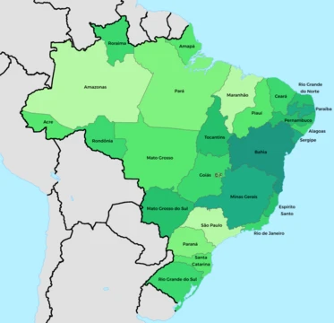
Rio Grande do Norte
Northeastern Brazilian state with the only South Atlantic atoll.

Rio Grande do Norte sits at the northeastern tip of South America, part of Brazil’s Northeast Region. Its name means “Great Northern River,” a reference to the mouth of the Potenji River. The state is defined by its coastline, with 410 kilometers of sandy beaches and the Rocas Atoll—the only atoll in the South Atlantic Ocean—located about 260 kilometers northeast of the capital, Natal.
Tourism drives the economy, followed by petroleum extraction (the state is Brazil’s second-largest producer), agriculture, fruit growing, and mineral extraction, including significant seasalt production. Rio Grande do Norte holds 1.7% of Brazil’s population and generates 1% of the country’s GDP. In 2017, the murder rate surged 655%, making it Brazil’s most violent state at 63.9 per 100,000 people, but it has since declined, dropping to 21.65 per 100,000 in 2023.
Notable attractions include the Cashew of Pirangi (the world’s largest cashew tree), the dunes and dromedaries of Genipabu, the beaches of Ponta Negra, Maracajaú, and Pipa, the Carnatal carnival, the 16th-century Forte dos Reis Magos, the hills of Martins, and the Natal Dunes State Park. Folklorist Luís da Câmara Cascudo was born and worked here. The state is the closest mainland point to the Fernando de Noronha archipelago.
**Geography** The state is dominated by its coast. NASA ranks its air as the second-cleanest globally, after Antarctica. Two climates prevail: humid tropical along the eastern coast and semi-arid across most of the state, including the northern coast. The rainforest that once lined Brazil’s coast ended in southern Rio Grande do Norte; north of Natal, dunes dominate, a formation tied to the semi-arid climate. Rainfall is not only low but erratic—some years see little or no rain. Most of the interior falls within the Polygon of Droughts, a federally monitored dry zone. Mangroves are common, and the interior is covered by rainforest. The Rocas Atoll is protected within the Atol das Rocas Biological Reserve.
**History** The Spaniard Alonso de Ojeda may have reached the region in 1499. Cape São Roque, 32 kilometers north of Natal, was first officially visited by Europeans in 1501–1502 during Amerigo Vespucci’s Portuguese expedition, which named it after the saint of the day. The same expedition called the Potengi River—Tupi for “River of Shrimps”—“Rio Grande” because of its wide mouth, a name later applied to the captaincy, province, and state. For decades, no permanent settlement existed; the area was inhabited by the Potiguara people. French pirates explored it between 1535 and 1598 for brazilwood. In 1598, the Portuguese built Forte dos Reis Magos and founded Natal the next year. Cattle raising and sugarcane plantations boosted local development.
In 1633, the region became a battleground between Portuguese expansionists and the Dutch, who had established a foothold in South America. After a brief period of peace and prosperity in Olinda and Recife, sugar prices fell in Amsterdam, triggering a severe economic crisis. This led Portuguese settlers and native Brazilians to revolt against the Dutch in the massacres of Cunhaú and Uruaçu. Religious tensions (Catholicism versus Dutch Calvinism), Portugal’s 1640 restoration of the throne, and the 1643 reconquest of Maranhão fueled a 1645 uprising led by André Vidal de Negreiros and João Fernandes Vieira. The governor of Bahia promised reinforcements, but most rebels were Africans and Amerindians. The Dutch were expelled in 1654.
During World War II, the state served as an Allied airbase for raids on German-occupied North Africa. In 1964, Latin America’s first space launch site, Barreira do Inferno (“Hell’s Barrier”), was built here, often called the “Brazilian NASA.”
**Demographics** As of December 1, 2021, the Brazilian Institute of Geography and Statistics estimated the population at 3,568,765—a 14.76% increase since 2000. The 2022 census shows multiracial people as the largest group at 50.9%, followed by white (39.5%), black (9.2%), indigenous (0.3%), and Asian (0.2%). Between 2000 and 2010, 77,916 migrants arrived, while 71,287 left.
**Education** Portuguese is the official language and primary school language; English and Spanish are part of the high school curriculum. The state’s main university is the Universidade Federal do Rio Grande do Norte (UFRN).
- Capital
- Natal
- Area
- Not specified in article
- Main economic activity
- Tourism
- Second largest petroleum producer in Bra
- Yes
Quick Facts
- Native Name Lang
- pt They made a movie about it!
- Settlement Type
- State
- Flag Size
- 125px
- Subdivision Type
- Country
- Subdivision Name
- Brazil
- Subdivision Type2
- Region
- Subdivision Name2
- Northeast
- Seat Type
- Capital and largest city
- Seat
- Natal
- Government Type
- Unitary state
- Leader Title
- Governor
- Leader Name
- Fátima Bezerra (PT)
Facts from the source article.
Lore & Background
The state of Rio Grande do Norte occupies the northeasternmost tip of the South American continent, within Brazil’s northeastern region. Its name, meaning “Great Northern River,” originates from the wide mouth of the Potenji River, so named by the 1501–1502 Portuguese expedition led by Amerigo Vespucci. The state boasts 410 kilometers of sandy beaches and includes the Rocas Atoll, the only atoll in the South Atlantic Ocean. Its coastline is the dominant geographic feature, famed for sand dunes and beaches; NASA has rated the air here as the second-cleanest in the world, after Antarctica. Two main climates prevail: humid tropical along the eastern coast, and semi-arid across the rest of the state, including the northern coast. The semi-arid interior, part of the federal Polygon of Droughts, experiences low and irregular rainfall, sometimes with years of little or no rain. The rainforest that once lined much of Brazil’s coast ends in the south of the state; north of the capital, Natal, the landscape is covered by dunes associated with the semi-arid climate. Mangroves are common, while the interior is dominated by rainforest. The state’s defining characteristics include its role as the closest mainland point to the Fernando de Noronha archipelago, its history as a World War II Allied airbase for raids on North Africa, and its status as home to Latin America’s first space launch site, Barreira do Inferno. The Potiguara people originally inhabited the area before European contact.
Reader's Guide
Rio Grande do Norte holds significance as the northeasternmost point of South America and as a key region in Brazil's colonial history, marked by early European exploration, conflict between Portuguese and Dutch forces, and the establishment of Natal. Its economy has shifted from sugar and cattle to tourism, which is now the main economic activity, alongside petroleum extraction (the state is the second largest producer in Brazil), agriculture, and mineral extraction including sea salt. The state is home to 1.7% of Brazil's population and produces 1% of the country's GDP. The state's infrastructure includes the second-best in the Northeast Region, and its international airport is the only one in the region to receive charter flights from Scandinavia. The folklorist Luís da Câmara Cascudo was born and worked in the state, and the state is the closest part of mainland Brazil to the archipelago of Fernando de Noronha.
Did You Know?
- Rio Grande do Norte contains Rocas Atoll, the only atoll in the South Atlantic Ocean.
- The state's air is, according to NASA, the second-cleanest in the world after Antarctica.
- The world's largest cashew tree, the Cashew of Pirangi, is located in the state.
More in Brazilian States 1-24
Spotted an error? Know more?
This is a living reference — every entry is fact-audited, and reader corrections feed straight into our audit queue. Suggest an edit · See this site's audit record