Rondônia
Brazilian state in the Amazon, named after explorer Cândido Rondon.

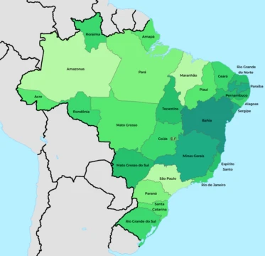
Rondônia is a state in Brazil’s North Region, positioned in the central-western part of the country. It shares borders with Acre to the west, Amazonas to the north, Mato Grosso to the east, and Bolivia to the south. As of 2021, its population is about 1,815,000, making it the fifth least populated state in Brazil. The capital and largest city is Porto Velho, which lies along the Madeira River. The state’s name honors Cândido Rondon, an explorer who traveled through northern Brazil in the 1910s. Rondônia accounts for roughly 0.7% of Brazil’s population and contributes about 0.3% of the national GDP.
The state covers 237,590.547 square kilometers—an area comparable to Romania and nearly five times larger than Slovakia or the Dominican Republic. It contains 52 municipalities. Besides Porto Velho, other important cities include Ariquemes, Cacoal, Guajará-Mirim, Ji-Paraná, Rolim de Moura, and Vilhena.
**Geography** Rondônia once held over 200,000 square kilometers of rainforest, but it has become one of the most deforested parts of the Amazon. By 2003, roughly 70,000 square kilometers of forest had been cleared. The area around the Guaporé River is part of the Beni savanna ecoregion. The Samuel Dam, located on the Jamari River, is also in the state.
**History** *Pre-colonial* Before the Portuguese arrival, the region now known as Rondônia was home to various indigenous peoples. These included speakers of Arawan languages (such as the Aruás), Chapacuran languages (like the Oro-uins), Macro-Je languages (such as the Jabutis), Nambikwaran languages (the Nambikwara), and Panoan languages (including the Kaxarari and Karipuna). Many Tupian-speaking groups also lived here, and linguists generally believe the area is the origin of the Tupian language family. Among these groups were the Cinta Larga, Gavião, Paiter, Amondauas, Macurap, Sakurabiat, Caritianas, and Araras-caros. Additionally, speakers of language isolates—the Kanoê and Kwazá—inhabited the region.
*Colonial period* The first European to reach the Guaporé River valley was the Spaniard Ñuflo de Chávez, who passed through between 1541 and 1542. Around 1650, bandeirantes arrived, seeking gold and other minerals. Jesuit priests soon followed, founding the first village. After gold was discovered on the right bank of the Guaporé River, the Portuguese Crown created the Captaincy of Mato Grosso in 1748, appointing Antonio Rolim de Moura Tavares as governor. On March 19, 1752, he made Vila Bela da Santíssima Trindade the capital, from where he oversaw border demarcation under the Treaty of Madrid (1750). In 1753, he set up a surveillance post at Santa Rosa Velha, a village built by the Spanish on Brazilian land. In 1759, the Spanish governor of Santa Cruz de la Sierra demanded its evacuation, so Rolim de Moura built a fort instead, called the Presídio de Nossa Senhora da Conceição. It soon fell into ruin due to climate and Spanish attacks. Rebuilt in 1769 by Governor Luís Pinto de Sousa Coutinho and renamed Forte de Bragança, it was again ruined, and in 1776 the Forte Príncipe da Beira replaced it. In 1772, Francisco de Melo Palheta led an expedition from Belém along the Madeira, Mamoré, and Guaporé Rivers to Santa Cruz de la Sierra. Mining declined, and after the proclamation of the First Brazilian Republic, the region lost economic importance until the rubber boom at the end of the nineteenth century.
*Postcolonial history* Rondônia’s early development was not driven by official government action. Instead, private initiative—spurred by interest in neighboring Acre during the Amazon rubber boom—populated and integrated the area. The clearing of both contiguous regions in the 19th century came from the same expansion movement, the last in Brazil’s territorial development cycle. Acre’s definitive establishment in 1903 boosted Rondônia’s growth, because the Treaty of Petrópolis required Brazil to build the Madeira-Mamoré railway. Decree-Law No. 5812, on September 13, 1943, created the Federal Territory of Guaporé from parts of Amazonas and Mato Grosso. On February 17, 1956, it was renamed the Federal Territory of Rondônia, after Marshal Cândido Rondon. Until the discovery of cassiterite deposits, brazil nuts and rubber were the main economic activities. That discovery sped up settlement and development. In the 1970s and 1980s, tax incentives for private businesses, federal investments, highway construction, colonization centers, and cheap, good land attracted migrants, mostly from Brazil’s Center-South Region. This growth led to statehood in 1982, with 13 founding municipalities: Porto Velho, Guajará-Mirim, Ji-Paraná, Vilhena, Ariquemes, Jaru, Pimenta Bueno, Colorado do Oeste, Cacoal, Ouro Preto do Oeste, Presidente Médici, Espigão d’Oeste, and Costa Marques.
**Demographics** Rondônia is the third most populous state in the North Region, with 1,815,278 residents.
- capital
- Porto Velho
- number_of_municipalities
- 52
- region
- North Region of Brazil
- named_after
- Cândido Rondon
Lore & Background
Before the Portuguese discovery of Brazil, the region now known as Rondônia was inhabited by diverse indigenous peoples, including speakers of Arawan, Chapacuran, Macro-Je, Nambikwaran, Panoan, and Tupian languages, as well as several language isolates. Linguists widely consider this area the origin of the Tupian language family. The first European explorer, a Spaniard, reached the Guaporé River valley in the 1540s, but only passed through. Bandeirantes arrived around 1650 seeking gold and other minerals, followed by Jesuit priests who founded the first village. The discovery of gold on the Guaporé’s right bank led the Portuguese Crown to create the Captaincy of Mato Grosso in 1748. A fort was built in the 1750s, later rebuilt and renamed Forte Príncipe da Beira in 1776. Mining declined after the First Brazilian Republic, and the region lost economic importance until the late 19th-century rubber boom. Rondônia’s development was driven by private interest in neighboring Acre, and the Treaty of Petrópolis (1903) required Brazil to build the Madeira-Mamoré railway. The federal territory was created in 1943 from parts of Amazonas and Mato Grosso, renamed in 1956 after Marshal Cândido Rondon. Cassiterite discoveries, tax incentives, highway construction, and colonization projects spurred migration from Brazil’s Center-South in the 1970s and 1980s, leading to statehood in 1982. Rondônia once held over 200,000 km² of rainforest, but by 2003 about 70,000 km² had been cleared, making it one of the Amazon’s most deforested areas. The Guaporé River region is part of the Beni savanna ecoregion, and the Samuel Dam lies on the Jamari River.
Reader's Guide
Rondônia's significance lies in its transformation from a sparsely populated indigenous territory to a state shaped by migration, resource extraction, and agricultural expansion. The Madeira-Mamoré railway, built after the Treaty of Petrópolis in 1903, spurred development. The Federal Territory of Guaporé was created in 1943 from parts of Amazonas and Mato Grosso, renamed Rondônia in 1956. Its economy relies on agriculture, livestock, food industry, and mineral extraction, with major exports including frozen beef and soy. Rondônia is also the origin area of the Tupian languages and home to over 20 indigenous languages.
Did You Know?
- Rondônia is named after Marshal Cândido Rondon, who explored northern Brazil in the 1910s.
- The Uru-Eu-Wau-Wau Indigenous Territory, covering over 1.8 million hectares, is the largest in the state.
More in Brazilian States 1-24
Spotted an error? Know more?
This is a living reference — every entry is fact-audited, and reader corrections feed straight into our audit queue. Suggest an edit · See this site's audit record