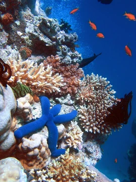
South Water Caye Marine Reserve
Second largest marine reserve in Belize, part of a World Heritage Site.

South Water Caye Marine Reserve is the second largest marine reserve in Belize, designated in 1996 by the Belize Fisheries Department, which manages it. It covers 117,875 acres (47,702 ha) of mangrove and coastal ecosystems in Stann Creek District and is part of the Belize Barrier Reef System, a World Heritage Site designated in 1996. The reserve is classified as an IV Habitat/Species Management Area.
Quick Facts
- Iucn Category
- IV
- Location
- Gulf of Honduras, Belize
- Nearest City
- Dangriga
- Area
- 117875 acre
- Established
- 1996
- Governing Body
- Ministry of Natural Resources and the Environment
Facts from the source article.
Lore & Background
The reserve lies on the inner side of the Belize Barrier Reef, 18 kilometers (11 miles) or between 8 to 25 kilometers (5.0 to 15.5 miles) off the coast of mainland Belize, and is over 40 kilometers (25 miles) long. It includes ecologically important mangrove cayes such as Pelican Cayes—considered 'one of the most biodiverse marine systems within the western hemisphere'—Twin Cayes, and Man-O-War Caye, which was previously designated a Crown Reserve in 1977. Some privately owned cayes are not part of the reserve.
The reserve provides habitat for at least 24 species that are vulnerable, endangered, or critically endangered: five coral species, three turtle species, 15 fish species, and the West Indian manatee. While many cayes are dominated by mangroves, some have shrub and coconut vegetation. Significant Maya sites have been found within the reserve.
Reader's Guide
Despite its protected status, most of the reserve's cayes have been leased for resort development, and large areas of mangroves have been cut down. A 2009 study found that of the Pelican Cayes' 53.3 hectares (132 acres) area, 15.4 hectares (38 acres)—29%—of mangrove forests had been cleared. Manatee Caye, Northeast Caye, and all but one of the Bird Cayes have also begun to be developed. In 2008, aerial photographs showed that mangroves had been removed from two of the Pelican Cayes; the government offered no explanation. Illegal fishing is also a problem. These concerns highlight the tension between conservation status and ongoing development pressures within the reserve.
Did You Know?
- It was designated a marine reserve in 1996 by the Belize Fisheries Department.
- A 2009 study found that 29% of mangrove forests in the Pelican Cayes had been cleared.
A Sand Bar, a Cave, and a Man-Made Channel
Caye Caulker is a low sand bar draped over a limestone shelf in the Caribbean, stretching roughly five miles north to south while never exceeding a mile in width. Beneath the surface, a limestone formation called Giant Cave lies embedded in the rock. To the east, a shallow lagoon ranging from six inches to fourteen feet deep meets the Belize Barrier Reef. Here the reef presents as a dry formation with coral exposed at the surface, transitioning further north into a deeper structure submerged under two to eight feet of water. This shallow, reef-adjacent setting has made the area a favorite among windsurfers. The island's most distinctive feature is the Split, a narrow waterway that bisects the landmass. Popular lore credits Hurricane Hattie in 1961 with creating it, but villagers who hand-dredged the channel dispute this. Village Council Chairman Ramon Reyes recalled that after the storm merely cracked a passage a few inches deep, he and neighbors dug it out by hand to accommodate dugout canoes between the west and east sides. Tidal currents later widened the channel to one hundred feet deep, permitting larger vessels to pass, while erosion of the sand banks continues to threaten further widening.
The Schoolhouse, the Surge, and a Lasting Vulnerability
When Hurricane Hattie struck in 1961, a violent storm surge swept across the narrowest stretch of the village. The wooden schoolhouse, pressed into service as a shelter, was torn apart by waves, killing thirteen people, most of them children. The eye of the storm passed south of the island, sparing it from even greater destruction. In the aftermath, the village council, backed by Governor Thornley's Emergency Committee, organized labor teams and raised approximately forty-two new houses within a matter of weeks. British Army helicopters delivered medical supplies and food to the stricken community. Yet the island's fundamental vulnerability remains unchanged. Its highest point reaches only eight feet above sea level, meaning a sufficiently powerful surge can submerge the entire landmass, as both Hattie and Hurricane Keith in 2000 demonstrated. Geomorphologists note that the low-relief carbonate sand resting atop a karst platform leaves the littoral zones extraordinarily exposed to rapid coastal reshaping during major tropical cyclones. Since Hattie, at least four additional major hurricanes have devastated the island, and no engineered defenses against storm surge exist to this day.
Fleeing the Yucatán and Building a Village
The precise origins of human presence on Caye Caulker stretch back hundreds of years, though the community as it is known today traces its roots to a moment of crisis. During the Caste War of Yucatan in 1847, mestizos of mixed Maya and Spanish heritage fled massacres across the Yucatán Peninsula, and many settled on this small Caribbean island, establishing the population base that would grow over the following decades. Around 1870, Queen Victoria granted the village area to a man named Luciano Reyes, who then sold lots to six or seven founding families. Remarkably, descendants of those original households still live on the island, and their influence on local life remains unmistakable. The choice of settlement location appears driven by practical maritime considerations that have held true for centuries. The bay behind the village offers sheltered mooring for boats, the reef to the front breaks the force of large waves, and the coral sand near the village provides firm anchorage where other parts of the island are soft mud. This combination of natural advantages explains why the main settlement has occupied essentially the same spot for what may be several hundred years.
A Mosaic of Peoples on a Growing Island
The 2010 census recorded a population of 1,763 residents on Caye Caulker, a figure that has since grown to approximately four thousand as tourism has transformed the island into a popular destination for backpackers and visitors. Over fifty hotels, along with numerous restaurants and shops, now line the streets of Caye Caulker Village. The demographic makeup reflects the island's layered history. Mestizo residents constitute the largest group at 65.6 percent, followed by Creole Belizeans at 15.3 percent and Caucasians at 4.3 percent. Smaller but significant communities include Ketchi Maya at 3.6 percent, Garifuna at 2.9 percent, Mopan Maya at 2.4 percent, and a scattering of other groups—mixed heritage, Asian, East Indian, African, Mennonite, Yucatec Maya, and others—each representing less than three percent. This mosaic mirrors the broader story of Belize itself, a nation built from waves of migration, displacement, and settlement. The island's accessibility, roughly twenty miles north-northeast of Belize City and reachable by high-speed water taxi or a short flight into Caye Caulker Airport, has only accelerated this blending, drawing new residents into a community whose roots reach back to the mid-nineteenth century.
Frequently Asked Questions
What is South Water Caye Marine Reserve?
It is a protected marine area in Belize encompassing roughly 117,875 acres of mangrove and coastal habitats. Officially established in 1996, it stands as the country's second-largest marine reserve.
Where is South Water Caye Marine Reserve located?
The reserve lies within Stann Creek District along Belize's coastline. It is also a component of the Belize Barrier Reef System, which received UNESCO World Heritage designation in 1996.
Who manages South Water Caye Marine Reserve?
The Belize Fisheries Department oversees the reserve's day-to-day protection and operations. That same department was the body responsible for designating the area back in 1996.
Why is South Water Caye Marine Reserve important?
As Belize's second-largest marine reserve, it shields a vast expanse of mangrove and coastal ecosystems that are vital to overall reef health. Its inclusion within the Belize Barrier Reef System World Heritage Site highlights its significance on a global conservation scale.
What conservation category does South Water Caye Marine Reserve fall under?
It is classified as an IUCN Category IV Habitat/Species Management Area. This category emphasizes active management of specific habitats and species rather than imposing strict no-entry restrictions across the entire zone.
More in Coral Reefs, Part 3 1-23
Spotted an error? Know more?
Reader corrections go straight into our review queue. Suggest an edit · How this site is sourced