South Khorasan province
Sparsely populated Iranian province with a distinct historical identity.

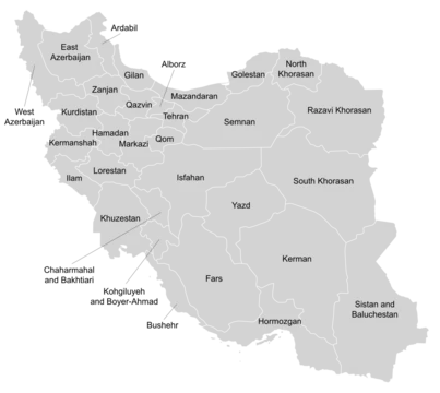
South Khorasan province, one of Iran’s 31 provinces, lies in the country’s eastern region, with Birjand as its capital. It was formed in 2004 when the former Khorasan province was split into three, and it largely matches the historic territory of Quhistan—a region with its own distinct culture, history, environment, and ecology. The province is bordered by Razavi Khorasan to the north, Semnan to the northwest, Isfahan and Yazd to the west, Kerman to the south, and Sistan and Baluchestan to the southeast.
Covering 151,913 square kilometers, South Khorasan is Iran’s third-largest province, after Kerman and Sistan and Baluchestan. Despite its size, the 2016 census recorded a population of just 768,898, making it the fourth least populous province and the most sparsely populated in the country. The landscape splits into two main parts: mountainous and elevated terrain in the north and northwest, and low, flat plains in the central and southern areas. The highest peaks include Kamarak and Shah Kuh. The climate is dry and desert-like, divided into hot-dry and mild-dry categories. The northern and northwestern zones are more fertile, while the southern and southwestern plains face a harsh, dry climate. Rivers here are seasonal, with no permanent waterways.
Historically, Greater Khorasan saw many dynasties and governments rise and fall. Various Arab, Turk, Kurd, and Turkmen tribes repeatedly reshaped the region. Ancient Iranian geographers divided Iran into eight parts, with Greater Khorasan being the largest and most prosperous. Esfarayen, for instance, was a key settlement for Aryan tribes after their arrival in Iran. The Parthian Empire was based near Merv in Khorasan for many years, and during that time Esfarayen was an important village of Nishapur. Under the Sassanids, a Spahbod (Lieutenant General) called Padgoosban governed the province, assisted by four margraves, each commanding one of its four quarters.
During the Muslim conquest of Persia, Khorasan was split into four sections, each named after a major city: Nishapur, Merv, Herat, and Balkh. In 651, the Islamic Arab army invaded Khorasan. The Abbasid clan held the territory until 820, followed by the Iranian Taherid clan in 896 and the Samanid dynasty in 900. Mahmud of Ghazni conquered Khorasan in 994, and in 1037 Toghrül, the first Seljuq ruler, took Nishapur. Mahmud retaliated several times, and eventually the Ghaznavids defeated Sultan Sanjar. But in 1157, the Khwarazmids conquered Khorasan, and simultaneous Mongol attacks later annexed it to the Mongol Ilkhanate. In the 14th century, the Sarbedaran movement raised a flag of independence in Sabzevar. In 1468, Tamerlane took Khorasan and made Herat his capital. Uzbek tribes occupied the region in 1507, and after Nader Shah’s death in 1747, parts were briefly held by Afghans.
During these periods, Birjand was a small part of Quhistan, which roughly matches today’s South Khorasan. The main cities of Quhistan were Toon (now Ferdows) and Qaen. Birjand grew in recent centuries, especially under the Qajar dynasty, and gained importance in the region. This area served as a refuge for movements like the Ismailis and for Arab refugees fleeing the Abbasid caliphate. Zoroastrian remains are also found here. In 1824, Herat became independent for several years after the Afghan Empire split between the Durranis and Barakzais. The Persians besieged the city in 1837, but the British helped the Afghans repel them. In 1856, the Persians invaded again and briefly recaptured Herat, leading directly to the Anglo-Persian War. Hostilities ended in 1857 with the Treaty of Paris, and Persian troops withdrew. Afghanistan reconquered Herat in 1863 under Dost Muhammad Khan, two weeks before his death.
South Khorasan is one of three provinces created from the division of Khorasan in 2004. Initially, it included only Birjand County and a few new counties detached from it—Nehbandan, Darmian, and Sarbisheh. In later years, all northern and western cities and territories of old Quhistan, such as Qaen, Ferdows, and Tabas, were annexed, so that by 2016 the province comprised 11 counties. Khorasan had been Iran’s largest province until it was split on 29 September 2004, following parliamentary approval on 18 May 2004 and the Council of Guardians’ approval on 29 May 2004.
Demographically, the 2006 census recorded a population of 600,568 in 159,255 households. By 2011, that had risen to 662,534 in 183,114 households. The 2016 census showed 768,898 people in 223,984 households. The province remains the least densely populated in Iran.
- capital
- Birjand
- population_density
- about 5 inhabitants per square kilometer
- established
- 29 September 2004 (division of Khorasan province)
Lore & Background
South Khorasan province was created on 29 September 2004, when the Iranian parliament and Council of Guardians approved the division of Khorasan—the largest province of Iran—into three provinces: Razavi Khorasan, North Khorasan, and South Khorasan. Initially, South Khorasan included only Birjand County and a few new counties detached from it, such as Nehbandan, Darmian, and Sarbisheh. The region historically known as Quhistan encompassed the borders of present-day South Khorasan, with main cities such as Toon (now Ferdows) and Qaen. Birjand grew in importance during the Qajar dynasty. The area served as a refuge for Ismaili movements and for Arab refugees fleeing the Abbasid caliphate, and Zoroastrian vestiges remain. The province's climate is dry and desert, divided into hot-dry and mild-dry categories, with seasonal rivers and no permanent rivers. The northern and northwestern parts are mountainous and more fertile, while the southern and southwestern plains endure a harsh climate.
Reader's Guide
South Khorasan province matters as a distinct administrative and historical entity within Iran, representing the legacy of the ancient region of Quhistan. Its creation in 2004 marked a significant reorganization of Iran's largest province, reflecting local cultural and ecological differences. The province is notable for being the most sparsely populated in Iran, with only about 5 inhabitants per square kilometer, and for its dry desert climate. Economically, South Khorasan is known for its rugs, saffron, and barberry production. The province's population is predominantly Persian, and its higher education institutions include the University of Birjand and Birjand University of Medical Sciences. Understanding South Khorasan provides insight into Iran's regional diversity, the historical importance of Khorasan, and the modern administrative divisions that shape the country.
Did You Know?
- South Khorasan is the third-largest province in Iran by area, after Kerman and Sistan and Baluchestan.
- The province is the most sparsely populated in Iran, with about 5 inhabitants per square kilometer.
- South Khorasan corresponds largely to the historical region of Quhistan, which has a distinct culture, history, environment, and ecology.
- The province was created in 2004 when Khorasan, Iran's largest province, was divided into three provinces.
Frequently Asked Questions
What is South Khorasan province?
South Khorasan is one of Iran's 31 provinces situated in the country's eastern region. It largely corresponds to the historical area known as Quhistan, which carries its own distinct cultural and ecological identity.
What is the capital of South Khorasan province?
Birjand serves as the provincial capital. It is the main urban center in an otherwise vast, arid landscape.
Why is South Khorasan province considered distinctive among Iranian provinces?
Its dry, desert climate and extremely low population density set it apart from most other provinces. The region also preserves the legacy of Quhistan, giving it a historical and cultural character that differs from neighboring areas.
More in Provinces Of Iran 1-24
Spotted an error? Know more?
This is a living reference — every entry is fact-audited, and reader corrections feed straight into our audit queue. Suggest an edit · See this site's audit record