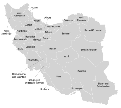
Ilam province
Western Iranian province with ancient Elamite roots.

Nasour golmohammadi · CC BY-SA 4.0
Ilam Province is one of Iran’s 31 provinces, situated in the western part of the country within Region 4. Its capital is the city of Ilam. The province shares a border with Iraq and is also adjacent to Kermanshah, Lorestan, and Khuzestan provinces.
The name “Ilam” derives from “Elam,” a prehistoric civilization that controlled parts of what is now southwestern Iran and southeastern Iraq from 2700 BC to 539 BC. Archaeological evidence indicates human settlement in the area dates back to around 5000 BC. In 639 BC, Assyrian king Ashurbanipal invaded and destroyed Elam, though the Elamites continued to inhabit the region. Between 612 and 546 BC, Elam was absorbed into the Median kingdom, and by 539 BC it became part of the Achaemenid Empire, where it lost its independence and became the empire’s third province, after Persis and Media. During the Median, Achaemenid, Seleucid, and Parthian periods, the area gained importance due to its proximity to Hamadan, Kurdistan, Kermanshah, Lorestan, and especially Susa. In the Sasanian era, present-day Ilam consisted of two states: Mehrjanqazaq in the east (modern Darreh Shahr) and Masbasan in the west.
Following the Muslim conquest of Mesopotamia in 640 AD, the Arabs called the region “Jibal,” meaning “Land of the Mountains.” The kingdom of Jibal, with its capital at Seymareh, was under the authority of Baghdad and Basra until 961 CE. The Rashidun Caliphate took control of Mesopotamia by 640 CE and the entire Sasanian Empire by 643 CE, ruling until its collapse in 661 CE. After a civil war, the Umayyad Caliphate emerged and governed the area until 750 AD, when the Abbasid Caliphate took over, lasting until 945 CE. The Buyid Dynasty then conquered western Iran in 945 CE and ruled the region until 1055.
From 1155 to 1424, Kurdish groups held power in the Zagros Mountains, particularly around Lorestan. The Hazaraspids, also known as the Lorestan Atabegs, were divided into two branches: the Little Lor, mostly of Lor descent, and the Big Lor Atabegs, of Kurdish descent. The Little Lor controlled parts of what are now Markazi, Hamedan, Kermanshah, Lorestan, Khuzestan, and Ilam provinces. Between 961 and 1015, the Ḥasanwayhid dynasty, Kurdish Muslims from the Barzikani tribe, ruled western Iran under Buyid influence from their center at Dinawar near Kermanshah. At its peak, this dynasty included areas around Khorramabad, Borujerd, Nahavand, Asadabad, Ahwaz, Ilam, Kermanshah, Hulwan, and Kirkuk. The Ḥasanwayhids were overthrown by the Annazids, who, with Buyid support, controlled the region until 1116 CE.
The Little Lor Atabegs, or Khorshidi dynasty, ruled for over 412 years, from 1184 to 1597 CE, with their capital at Shapourkhwast (modern Khorramabad) and the Falak-ol-Aflak Castle. Shah Abbas the Great ended this rule by executing the last ruler, Shahverdi Khan, and appointing his nephew, Hossein Beyg/Khan, beginning the Vali (or Wali) dynasty, also known as the Feyli Vali.
During the Qajar era (1789–1925), Lorestan was split into two regions: Poshtkoh (present-day Ilam province) with Ilam city as its center, and Pishkouh (present-day Lorestan) with Khorramabad as its center. The name Poshtkouh means “back of the mountain,” reflecting Ilam’s location on the western side of the Zagros Mountains. From then on, Ilam was governed independently from Lorestan, with its governor reporting directly to the central government. The two districts were later renamed “Deh-e Bala” and “Deh-e Pa’een” (upper and lower villages). During Hossein Qoli Khan’s rule over Deh-e Bala (1863–1900 CE), it was renamed “Hossein-Abad Poshtkuh.” The Vali Castle of Ilam was built in 1908 by Gholamreza Khan Feyli; it is now a nationally registered heritage site and houses the Ilam Museum of Anthropology.
After the Pahlavi dynasty was established in 1925, Reza Shah moved to suppress local governments. In 1928, government forces took over Poshtkouh, and Gholamreza Khan Feyli, the last Feyli governor, left for Iraq without resistance, ending 332 years of Feyli rule in Ilam. In 1929, the Academy of Persian Language and Literature suggested renaming “Hossein-Abad” to “Ilam.” On 7 November 1937, a law divided the country into 6 provinces and 50 counties, making Poshtkouh a county within the “West Province.” This division was amended on 9 January 1938.
- capital
- Ilam city
- region
- Region 4
Lore & Background
During the Sasanian era, the area now known as Ilam province was divided into two distinct states: Mehrjanqazaq in the east, corresponding to the modern city of Darreh Shahr, and Masbasan in the west. The province lies in western Iran, within Region 4, and shares a border with Iraq as well as the Iranian provinces of Kermanshah, Lorestan, and Khuzestan. Its capital is the city of Ilam. The name "Ilam" derives from "Elam," a prehistoric civilization that dominated southwestern Iran and southeastern Iraq from 2700 BC to 539 BC. Archaeological evidence indicates human settlement in the region dates back to around 5000 BC. The Assyrian king Ashurbanipal invaded and destroyed Elam in 639 BC, though the Elamite people persisted in the area. Between 612 and 546 BC, Elam was absorbed into the Median kingdom, and later into the Achaemenid Empire in 539 BC, where it became the empire’s third province after Persis and Media. During the Median, Achaemenid, Seleucid, and Parthian periods, the region gained importance due to its proximity to districts such as Hamadan, Kurdistan, Kermanshah, Lorestan, and notably Susa.
Reader's Guide
The province lies in the western part of Iran within Region 4 and shares a border with Iraq, as well as the provinces of Kermanshah, Lorestan, and Khuzestan. Its name derives from the prehistoric Elamite civilization, which ruled the region from 2700 BC to 539 BC, and archaeological evidence indicates human settlement in the area dating to around 5000 BC. The Assyrian king Ashurbanipal invaded and destroyed Elam in 639 BC, though the Elamites persisted in the region. Subsequently, the area was incorporated into the Median kingdom between 612 and 546 BC, then into the Achaemenid Empire in 539 BC, where it became the empire’s third province after Persis and Media. During the Median, Achaemenid, Seleucid, and Parthian periods, its settlements gained importance due to proximity to Hamadan, Kurdistan, Kermanshah, Lorestan, and notably Susa. In the Sasanian era, present-day Ilam comprised two states: Mehrjanqazaq in the east (modern Darreh Shahr) and Masbasan in the west. Following the Muslim conquest of Mesopotamia in 640 AD, Arabs called the area “Jibal” (Land of the Mountains), with its capital at Seymareh under Baghdad and Basra until 961 CE. The region later saw rule by the Buyid Dynasty from 945 CE, then by Kurdish dynasties such as the Hasanwayhids (961–1015 CE) and the Hazaraspids (1155–1424 CE). The Khorshidi dynasty, or Little Lor Atabegs, ruled for over 412 years until 1597 CE, after which Shah Abbas the Great installed the Vali dynasty. During the Qajar era, Ilam was known as Poshtkuh, governed independently from Lorestan, with its capital at Ilam city. The Vali Castle was built in 1908 and now houses the Ilam Museum of Anthropology. In 1928, the last Feyli governor left for Iraq, ending local rule after 332 years, and the area was renamed Ilam in 1929.
Did You Know?
- During the Iran–Iraq War, Ilam was a constant target for Iraqi bombing and suffered heavily.
Ancient Roots and the Elamite Legacy
The name Ilam traces directly to Elam, a prehistoric civilization that dominated the region spanning modern southwest Iran and southeast Iraq for over two millennia, from roughly 2700 BC until 539 BC. Archaeological evidence pushes human settlement in this area back to approximately 5000 BC, making it one of the oldest continuously inhabited zones in the region. The civilization's trajectory was shaped by successive empires: Ashurbanipal of Assyria launched a devastating invasion in 639 BC that shattered Elam's unity, though the Elamite people persisted in the area. Between 612 and 546 BC the territory fell under Median control, and in 539 BC it was absorbed into the Achaemenid Empire, where it lost its independence permanently and was designated the third province after Persis and Media. Throughout the subsequent Median, Achaemenid, Seleucid, and Parthian periods, the area's strategic position near Hamadan, Kurdistan, Kermanshah, Lorestan, and especially Susa kept it politically significant. By the Sasanian era the region had reorganized into two distinct states: Mehrjanqazaq in the east, corresponding to today's Darreh Shahr, and Masbasan in the west.
Arab Conquest and the Long Kurdish Reign
After the Muslim conquest of Mesopotamia in 640 CE, Arab rulers designated the area Jibal, meaning the Land of the Mountains, with its capital at Seymareh. This kingdom operated under the authority of Baghdad and Basra and endured until 961 CE. The political landscape shifted through successive caliphates—the Rashidun, Umayyad, and Abbasid—before the Buyid Dynasty seized control of western Iran in 945 CE and held it until 1055. The most enduring chapter was Kurdish rule in the Zagros Mountains, lasting 270 years from 1155 to 1424. The Hazaraspids, known as the Lorestan Atabegs, split into the Little Lor of Lor descent and the Big Lor Atabegs of Kurdish descent, together governing parts of what are now Markazi, Hamedan, Kermanshah, Lorestan, Khuzestan, and Ilam. The Hasanwayhid dynasty, Kurdish Muslims linked to the Barzikani tribe, ruled from Dinawar between 961 and 1015, at its peak stretching from Khorramabad and Borujerd to Ahwaz, Ilam, Kermanshah, Hulwan, and even Kirkuk. They were overthrown by the Annazids, who held power until 1116 CE.
The Khorshidi Dynasty and the Vali Era
The Khorshidi dynasty, also called the Little Lor Atabegs, governed the region for an extraordinary 412 years, from 1184 to 1597 CE. Their capital was Shapourkhwast, the modern-day Khorramabad, particularly the Falak-ol-Aflak Castle. Their rule ended abruptly when Shah Abbas the Great executed the last Khorshidi ruler, Shahverdi Khan, and installed Shahverdi's nephew Hossein Beyg, inaugurating the Vali or Feyli dynasty. This new line of governors would hold power for another 332 years. During the Qajar period, Lorestan was split into two administrative regions: Poshtkoh, centered on Ilam city, and Pishkouh, centered on Khorramabad. The name Poshtkoh, meaning back of the mountain, reflected Ilam's position at the westernmost edge of the Zagros range, making it seem remote to the rest of the country. From this point Ilam was administered independently of Lorestan, with its governor reporting directly to the central government. Under Hossein Qoli Khan's rule of Deh-e Bala from 1863 to 1900, the area was renamed Hossein-Abad Poshtkuh. In 1908, the next Vali, Gholamreza Khan Feyli, commissioned the Vali Castle, which today stands as a nationally registered heritage site and houses the Ilam Museum of Anthropology.
Modern Statehood and the War Years
Following the Pahlavi dynasty's rise in 1925, Reza Shah moved to suppress local governance and centralize authority. In 1928, government forces took over Poshtkouh, and Gholamreza Khan Feyli, the last Feyli governor, departed for Iraq without resistance, ending 332 years of Feyli rule. The following year, in 1929, the name Hossein-Abad was changed to Ilam on the recommendation of the Academy of Persian Language and Literature, reviving the ancient Elamite name. The province's administrative status evolved through a series of political divisions: a 1937 law placed Poshtkouh as a county within the West Province, but an amendment in January 1938 reorganized the country into ten provinces, making Ilam a county of the Fifth Province. In 1964, the counties of Darreh Shahr, Abdanan, and Dehloran from Lorestan, along with Mousian from Khuzestan, were annexed to Ilam, elevating it to a general governorate under Kermanshah Province. Ilam finally achieved full provincial status in March 1974. After the 1979 Iranian Revolution, the province became one of the principal battlegrounds of the Iran-Iraq War, which began with Iraq's invasion of western and southwestern Iran on 22 September 1980.
Gallery
Frequently Asked Questions
Why do fans consider Ilam Province important in the broader map of Iran?
Its long Iraq border and position in Region 4 give it strategic and cultural weight as a gateway between Iran and Mesopotamian history. Combined with its Elamite heritage, it stands out as one of the country's most historically layered western provinces.
More in Provinces Of Iran 1-24
Spotted an error? Know more?
This is a living reference — every entry is fact-audited, and reader corrections feed straight into our audit queue. Suggest an edit · See this site's audit record