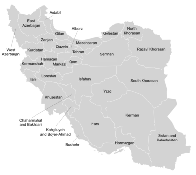
Mazandaran province
Iranian province on the Caspian Sea with rich history and natural resources.

Mazandaran is one of Iran's 31 provinces, with Sari as its capital. It stretches along the Caspian Sea's southern shore and into the Central Alborz range and Hyrcanian forests, bordering Golestan, Semnan, Tehran, Alborz, Qazvin, and Gilan provinces. Covering 24,842 square kilometers, its landscapes shift from sandy Caspian beaches to the rugged, snow-covered Alborz peaks, including Mount Damavand—one of Asia's highest mountains and volcanoes. The province holds large offshore oil and natural gas reserves. Its economy relies heavily on agriculture, with fish farming a major industry, and tourism draws visitors from across Iran. Biotechnology is also expanding rapidly here.
The name "Mazandaran" comes from Avestan, meaning "gate of the giants" or "valley of the giants," combining *mâz* (giant), *an-dar* (in/within), and *-ân* (suffix). The 10th-century Persian epic *Shahnameh* describes it as a land of *daevas* (supernatural beings in Zoroastrian belief) and sorcerers, difficult to conquer. Local place names like Div Asiyab, Div Cheshmeh, Div Kela, and Div Hamam still include the word *div*.
Human settlement here goes back at least 75,000 years. Excavations at Gohar Tape in Rostamkola show urbanization over 5,000 years, making it one of Iran's most historically significant sites. The indigenous Mazanderani people speak a language closely related to Gilaki and Sangiseri, with phonetic similarities to some Caucasian languages, reflecting the region's history. In the early 20th century, Reza Shah built seven new roads and railways linking the northern Alborz to the southern slopes, and the provinces of Mazandaran and Gilan became known collectively as *Shomal* (Persian for "the North"). On June 22, 2014, Mazandaran was grouped into Region 1 for coordination and development.
Before Iranian-speakers arrived, the area's inhabitants were subsistence hunters and cattle herders. Archaeological finds in Belt and Hotu caves near Behshahr show human presence around 9,000 years ago. The Amard tribe lived in the mountainous Caspian region, including modern Amol. The Tapuri tribe, mentioned by Ptolemy and Arrian, inhabited the Medes' territory south of the Caspian. Ctesias placed Tapuri between the Cadusii and Hyrcania. The region changed hands among many dynasties, with Parthian and Sasanian fortresses and older cemeteries scattered throughout. During that era, it was part of Hyrcania, a key province. In 662 CE, ten years after the last Sasanian emperor Yazdegerd III's death, a Muslim army led by Hassan ibn Ali invaded Tabarestan.
Under the Sasanian Empire, the King of Mazandaran (Tabaristan and Padashkhwargar) was Gushnasp, whose ancestors had ruled since Alexander the Great's time. From 529–536, the Sasanian prince Kawus, son of Kawadh, governed Mazandaran. Sasanian king Anushirawan defeated Zarmihr, who claimed descent from the legendary blacksmith Kaveh. This dynasty ruled until 645 AD, when Gil Gilanshah—a descendant of Sasanian king Jamasp and grandson of Piruz—united Mazandaran with Gilan. After the Sasanian Empire fell in 651, Arab control gradually spread, but the Caspian region, including Tabaristan, remained independent.
Tabaristan stayed independent from the Umayyad Caliphate, with Zoroastrian houses like the Bavand and Karen waging effective guerrilla warfare. A short-lived Alid Shiite state collapsed, followed by Ziyarid rule. Post-Islamic local dynasties fell into three groups: pre-Islamic local families, Alid sayyids, and minor local families. The Karinids, claiming descent from Karin (brother of Zarmihr), saw their last representative, Mazyar, executed in 839. Between the 9th and 11th centuries, the Rus' launched repeated military raids on the Caspian shores of Iran, Azerbaijan, and Dagestan, part of their Caspian expeditions. Initially, they appeared in the 9th century as merchants along the Volga trade route, selling furs, honey, and slaves.
- Capital
- Sari
- Bordering Provinces
- Golestan, Semnan, Tehran, Alborz, Qazvin, Gilan
- Major Economic Sectors
- Agriculture, aquaculture, tourism, biotechnology
- Notable Peak
- Mount Damavand
- Historical Region
- Tabaristan
Lore & Background
Mazandaran province lies along Iran’s southern Caspian coast, stretching from sandy beaches up through the Hyrcanian forests and into the rugged, snow-capped Central Alborz range, which includes Mount Damavand, one of Asia’s highest peaks and volcanoes. It covers 24,842 square kilometers and borders Golestan, Semnan, Tehran, Alborz, Qazvin, and Gilan provinces. The province’s diverse habitats—plains, prairies, forests, and rainforests—support rich natural resources, including large offshore oil and natural gas reservoirs. The area has been inhabited for at least 75,000 years, with excavations at Gohar Tape in Rostamkola showing urbanization dating back over 5,000 years, making it a key historical site. Indigenous Mazanderanis speak an Iranian language closely related to Gilaki and Sangiseri, with phono-typical links to several Caucasian languages. Historically, the region was part of Hyrcania and later known as Tabaristan, ruled by pre-Islamic dynasties such as the Bavand and Karen houses, which maintained independence from the Umayyad Caliphate through guerrilla warfare. In the early 20th century, Reza Shah built roads and railways connecting the northern Elbourz to the south, cementing the area’s identity as “Shomal” (the North) for all Iranians. Today, the economy relies on agriculture, aquaculture (especially farmed fish), tourism from across Iran, and a fast-growing biotechnology sector.
Reader's Guide
Mazandaran province, located along the southern Caspian Sea coast and the Central Alborz range, encompasses diverse habitats from sandy beaches to snowcapped mountains, including Mount Damavand. Its natural resources include large offshore oil and natural gas reservoirs. The economy relies on agriculture, aquaculture—making it a major producer of farmed fish—and a significant tourism industry drawing visitors from across Iran. It is also a fast-growing biotechnology centre. The name derives from Avestan, meaning "the gate of the giants," and appears in the 10th-century Persian epic *Shahnameh* as a land of supernatural beings and sorcerers. Toponyms in the province include several names containing the word *div*, such as Div Asiyab and Div Cheshmeh. Human habitation dates back at least 75,000 years, with urbanization evidence from Gohar Tape in Rostamkola spanning over 5,000 years. The indigenous Mazanderani people speak an Iranian language closely related to Gilaki and Sangiseri, with phonetic similarities to several Caucasian languages. Historically, the area was part of Hyrcania during the Sasanian era, with fortresses from the Parthian and Sasanian empires still standing. Local pre-Islamic dynasties included the Bavandids and Karinids, while the Amard and Tapuri tribes were early inhabitants. After the Sasanian fall, Tabaristan maintained independence from the Umayyad Caliphate through Zoroastrian houses. In the early 20th century, Reza Shah built roads and railways connecting the northern Elbourz to the southern slopes, leading the province to be called Shomal ("the North") by all Iranians.
Did You Know?
- The name 'Mazandaran' is Avestan for 'the gate of the giants' or 'the valley of the giants.'
- Mount Damavand, one of the highest peaks and volcanoes in Asia, is located in Mazandaran.
- In the Safavid era, large numbers of Georgians, Circassians, and Armenians were settled in Mazandaran.
Frequently Asked Questions
What is Mazandaran province?
Mazandaran is one of Iran's 31 provinces, stretching along the southern Caspian Sea coastline and into the Central Alborz mountain region. Its capital and administrative seat is the city of Sari.
What are Mazandaran province's main economic roles?
The province drives significant output in agriculture, aquaculture, and tourism, while also sitting atop large offshore oil and natural gas reserves. Biotechnology has become an additional pillar of its modern economy.
What makes Mazandaran's geography stand out?
The terrain shifts from sandy Caspian beaches to the snowcapped Alborz sierra, which includes Mount Damavand, one of Asia's tallest volcanic peaks. This range of habitats also shelters the ancient Hyrcanian forest ecosystems.
Why is Mazandaran historically important?
The area corresponds to the ancient region of Tabaristan, anchoring it in centuries of Persian cultural and political history. Its position between the Caspian Sea and the Alborz mountains long made it a vital corridor for trade and movement.
More in Provinces Of Iran 1-24
Spotted an error? Know more?
This is a living reference — every entry is fact-audited, and reader corrections feed straight into our audit queue. Suggest an edit · See this site's audit record