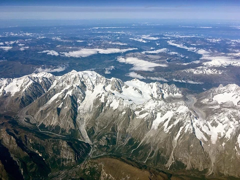
Arakan Mountains
Mountain range dividing Rakhine coast from central Myanmar.

The Arakan Mountains, known natively as the Rakhine Yoma and technically as the Southern Indo-Burman Range, form a prominent mountain system in western Myanmar. They stretch from Cape Negrais in the south northward into Manipur, India, and are the most significant of several parallel ridges that arc through Assam, Nagaland, Manipur, Mizoram, and Myanmar. The range includes the Naga Hills, the Chin Hills, and the Patkai range, which contains the Lushai Hills. The mountain chain extends underwater in the Bay of Bengal before re-emerging as the Andaman and Nicobar Islands. The name "Arakan" derives from the Sanskrit word *Rakshasa*, meaning demon, a term historically used for the region’s inhabitants.
Geologically, the Arakan Mountains and their parallel arcs formed from compression caused by the collision of the Indian Plate with the Eurasian Plate, roughly along the boundary between India and Myanmar, creating the Naga-Patkai foldbelt. The range spans over 950 kilometers (about 600 miles), with approximately 400 kilometers (250 miles) of continuous mountain terrain. Its highest peak is Khonu Msung, also called Mount Victoria. The mountains serve as a natural barrier between the Rakhine coast and central Myanmar, separating the Irrawaddy River basin from the coastal plain. This division has historically fostered the distinct linguistic and cultural development of the Rakhine people, shielding them from central Burmese influence and allowing coastal cities like Mrauk U and Waithali to form the core of Arakan civilization. The range also hindered Burmese invasions, enabling Arakan to maintain political independence.
During World War II, fierce battles occurred in these mountains between January 1943 and March 1944, when Japanese 33rd and 55th Divisions faced British forces on the coastal side; the British emerged victorious. As of 2026, the Arakan Army, Student Armed Force, and allied Chin groups have established territorial control and defensive lines across the range to limit advances by the Myanmar junta. Ecologically, the mountains block the southwestern monsoon, causing the western slopes to receive over one meter of rain per month during the monsoon season, while the eastern slopes remain much drier. The region includes the Chin Hills-Arakan Yoma montane forests ecoregion, home to an elephant population and the critically endangered Arakan forest turtle,
- location
- western Myanmar, between Rakhine State coast and Central Myanmar Basin
- native_name
- Rakhine Yoma (Burmese: ရခိုင်ရိုးမ)
- formation
- compression from Indian Plate colliding with Eurasian Plate
- ecoregion
- Chin Hills-Arakan Yoma montane forests
Lore & Background
The Arakan Mountains, known natively as Rakhine Yoma and technically as the Southern Indo-Burman Range, form a prominent arc of parallel ridges stretching from Cape Negrais in southern Myanmar northward into Manipur, India. This chain includes the Naga Hills, Chin Hills, Patkai range, and Lushai Hills, and extends over 600 miles in length, with approximately 250 miles of continuous mountainous terrain. The range is submerged beneath the Bay of Bengal for a long stretch before re-emerging as the Andaman and Nicobar Islands. Its highest point is Khonu Msung, also called Mount Victoria. The mountains act as a formidable barrier, dividing the Rakhine coast from central Myanmar. This separation has historically fostered the distinct linguistic and cultural development of the Rakhine people, while also inhibiting invasions from central Myanmar and allowing coastal cities like Mrauk U and Waithali to form the core of Arakan civilization. During World War II, fierce battles occurred here between January 1943 and March 1944, with British forces defeating Japanese divisions on the coastal side. Ecologically, the range blocks the southwestern monsoon, drenching its western slopes with over one meter of rain monthly while leaving the eastern slopes much drier. This environment supports the Chin Hills-Arakan Yoma montane forests, home to elephants and the critically endangered Arakan forest turtle, thought extinct until its rediscovery in 1994. The mountains are crossed by a road between Ann and Minbu and an all-weather route from Taungup to Pyay.
Reader's Guide
The Arakan Mountains, known locally as the Rakhine Yoma, form a major geological and ecological barrier in western Myanmar. Geologically, they arose from the collision of the Indian and Eurasian plates, creating the Naga-Patkai foldbelt. Stretching over 950 kilometers from Cape Negrais in the south to Manipur, India, the range includes the Naga Hills, Chin Hills, and Patkai range, with its highest peak, Khonu Msung (Mount Victoria), reaching 3,094 meters. The chain submerges into the Bay of Bengal before re-emerging as the Andaman and Nicobar Islands. Ecologically, the mountains block the southwestern monsoon, causing extraordinarily heavy rainfall—often over one meter per month—on the western slopes, while the eastern side remains much drier. This supports the Chin Hills-Arakan Yoma montane forests ecoregion, home to elephants and the critically endangered Arakan forest turtle, thought extinct until its rediscovery in 1994. Historically, the range has separated the Rakhine coast from central Myanmar, fostering the distinct linguistic and cultural identity of the Rakhine people and enabling the development of a separate political entity, with coastal cities like Mrauk U and Waithali as its core. During World War II, fierce battles occurred here between January 1943 and March 1944, where British forces defeated Japanese divisions. As of 2026, the Arakan Army, Student Armed Force, and allied Chin groups control parts of the range, limiting junta advances. Infrastructure includes a road between Ann and Minbu and an all-weather road from Taungup to Pyay.
Did You Know?
- The Arakan Mountains are listed as 950 km (590 mi) long in the source.
- The range acts as a barrier to the southwestern monsoon rains, with western slopes receiving typically over 1 metre (39 in) of rain per month.
- The mountains are crossed by a road between Ann and Minbu and by an all-weather road from Taungup to Pyay on the Irrawaddy.
- The range fostered the separate development of the Rakhine people linguistically and culturally from the Burmese.
- Coastal cities such as Mrauk U and Waithali formed the core of Arakan civilization.
Frequently Asked Questions
Who is Arakan Mountains?
The Arakan Mountains, natively called Rakhine Yoma, are a major mountain chain in western Myanmar that stretches from Cape Negrais in the south up to Manipur, India, in the north. They form the structural backbone of the region, separating the Rakhine coastal strip from the Central Myanmar Basin.
Why is Arakan Mountains important?
The chain acts as the defining geographic divide between Myanmar's western coast and its central lowlands, shaping regional climate, river drainage, and human settlement patterns. It also encompasses the Naga Hills, Chin Hills, and Patkai range, making it a key structural component of the broader Indo-Burman system.
More in Mountain Ranges And Massifs 1-24
Related in Mountain Ranges And Massifs
Links follow this subject's own source article.
Spotted an error? Know more?
This is a living reference — every entry is fact-audited, and reader corrections feed straight into our audit queue. Suggest an edit · See this site's audit record