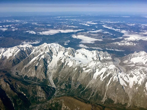
Atlas Mountains
North African mountain range separating Sahara from Mediterranean and Atlantic.

The Atlas Mountains run for about 2,500 kilometers across Morocco, Algeria, and Tunisia in North Africa’s Maghreb region. They form a natural barrier between the Sahara Desert and the Mediterranean Sea and Atlantic Ocean. The highest point in the range is Toubkal, located in central Morocco, which rises to 4,167 meters. These mountains are named after the Titan Atlas from Greek mythology. Most of the people living here are Berbers. In some Berber languages, the words for “mountain” are *Adrar* and *adras*, which linguists think are related to the name “Atlas.” The climate is generally cool, with sunny summers and an average temperature of 25 °C. The range hosts many plants and animals that are mostly African, though some also appear in Europe. Numerous species are endangered, and a few have already gone extinct. Geologically, the Atlas Mountains are much younger than the ancient Precambrian basement rock of Africa. They formed in three distinct phases. The first phase, about 300 million years ago during the Paleozoic, created only the Anti-Atlas range through continental collisions when North America, Europe, and Africa were connected. This chain was originally part of the Alleghenian orogeny, rivaling the Himalayas, and its remnants are visible in the Fall Line region of the eastern United States and the later Appalachians. The second phase occurred in the Mesozoic, before about 66 million years ago, when the Earth’s crust stretched and rifted the continents apart, forming thick sedimentary basins—including the present Atlas—where most of the High Atlas’s surface rocks were deposited under the ocean. The third phase, during the Paleogene and Neogene (roughly 66 million to 1.8 million years ago), saw the uplift of the Atlas ranges as Europe and Africa collided near the Iberian Peninsula. This convergent tectonic boundary also helped close the Strait of Gibraltar and build the Alps and Pyrenees. However, geologists note that the Atlas shows surprisingly little crustal thickening or shortening for its height, and recent research suggests deep mantle processes may have driven the uplift of the High and Middle Atlas. The mountains are rich in natural resources, including iron ore, lead, copper, silver, mercury, rock salt, phosphate, marble, anthracite coal, and natural gas. The range is divided into four subranges: the Anti-Atlas, High Atlas, and Middle Atlas in Morocco; the Tell Atlas running through Morocco, Algeria, and Tunisia; the Aurès Mountains in Algeria and Tunisia; and the Saharan Atlas in Algeria. The Anti-Atlas stretches about 500 kilometers from Morocco’s Atlantic coast northeast to Ouarzazate and Tafilalt, bordering the Sahara to the south. Its easternmost point is the Jbel Saghro range, and it is flanked by the High Atlas to the north. It includes the volcanic Djebel Siroua massif, whose highest summit reaches 3,304 meters, and the lower Jebel Bani range along its southern side. The High Atlas rises from the Atlantic coast in western Morocco and runs east to the Algerian border. It contains several peaks above 4,000 meters, including Toubkal (4,167 m) and Ighil m’Goun (4,071 m). To the southwest, the range drops sharply to the coast and the Anti-Atlas; to the north, it descends more gently toward Marrakesh. The Draa Valley cuts through the massif near Ouarzazate, opening southward. Berber people live in small villages here, farming the high plains of the Ourika Valley. A hydroelectric dam near Barrage Cavagnac created Lake Lalla Takerkoust, which provides fish for local fishermen. Major towns include Ouarzazate, Tahannaout, Amizmiz, Imlil, Tin Mal, and Ijoukak. The Middle Atlas lies entirely in Morocco, north of the High Atlas and separated from it by the Moulouya and Oum Er-Rbia rivers. To the north, the Sebou River divides it from the Rif mountains. To the west are Morocco’s main coastal plains and cities; to the east lies a barren plateau between the Saharan and Tell Atlas.
- Highest peak
- Toubkal, 4,167 m (13,671 ft)
- Location
- Morocco, Algeria, Tunisia
- Length
- Approximately 2,500 km (1,600 mi)
- Primary inhabitants
- Berber populations
- Major subranges
- Anti-Atlas, High Atlas, Middle Atlas, Tell Atlas, Saharan Atlas, Aurès Mountains
- Natural resources
- Iron ore, lead ore, copper, silver, mercury, rock salt, phosphate, marble, anthr
Lore & Background
The Atlas Mountains were formed during three subsequent phases of Earth's geology. The first tectonic deformation phase involves only the Anti-Atlas, which was formed in the Paleozoic Era (~300 million years ago) as the result of continental collisions. The Anti-Atlas Mountains are believed to have originally been formed as part of the Alleghenian orogeny, when Africa and America collided, and were once a chain rivaling today's Himalayas. A second phase took place during the Mesozoic Era (before ~66 My), consisting of a widespread extension of the Earth's crust that rifted and separated the continents. This extension was responsible for the formation of many thick intracontinental sedimentary basins including the present Atlas. In the Paleogene and Neogene Periods (~66 million to ~1.8 million years ago), the mountain chains that today constitute the Atlas were uplifted, as the land masses of Europe and Africa collided at the southern end of the Iberian Peninsula. However, there is a lack of evidence for the nature of the subduction in the Atlas region, or for the thickening of the Earth's crust generally associated with continental collisions. Recent studies suggest that deep processes rooted in the Earth's mantle may have contributed to the uplift of the High and Middle Atlas.
Reader's Guide
The Atlas Mountains are rich in natural resources, including deposits of iron ore, lead ore, copper, silver, mercury, rock salt, phosphate, marble, anthracite coal and natural gas. The range can be divided into four general regions: Anti-Atlas, High Atlas and Middle Atlas (Morocco); Tell Atlas (Morocco, Algeria, Tunisia); Aurès Mountains (Algeria, Tunisia); and Saharan Atlas (Algeria). The High Atlas in central Morocco rises at the Atlantic coast and stretches east to the Moroccan-Algerian border, with several peaks over 4,000 m (13,000 ft), including the highest summit in North Africa, Toubkal (4,167 m or 13,671 ft). The Middle Atlas is completely in Morocco and is the northernmost of its three main Atlas ranges, experiencing more rain than the ranges to the south and home to the majority of the world's population of Barbary macaque. The Tell Atlas is a mountain chain over 1,500 kilometres (900 mi) in length, stretching from Eastern Morocco to Tunisia, and through Algeria, with the highest summit being the 2,308 m (7,572 ft) Lalla Khadidja. The Aurès Mountains are the easternmost portion of the Atlas mountain range, covering parts of Algeria and Tunisia. Flora in the mountains include the Atlas cedar, evergreen oak and many semi-evergreen oaks such as the Algerian oak. Animals that live in the area include the Barbary macaque, Barbary leopard, Barbary stag, Barbary sheep, Atlas Mountain badger, Cuvier's gazelle, North African boar, striped hyena, red fox, northern bald ibis, Algerian nuthatch, dipper, and Atlas mountain viper. Many animals used to inhabit the Atlas mountains such as the Atlas bear, North African elephant, North African aurochs, bubal hartebeest and Atlas wild ass, but these subspecies are all extinct. Barbary lions are currently extinct in the wild, but descendants exist in captivity.
Did You Know?
- The Berber terms for 'mountain'—Adrar and adras—are believed to be cognates of the toponym Atlas.
- The Anti-Atlas Mountains were once a chain rivaling today's Himalayas when Africa and America collided.
- The highest peak in North Africa, Toubkal, has an elevation of 4,167 metres (13,671 ft).
- The Middle Atlas is home to the majority of the world's population of Barbary macaque.
- Barbary lions are currently extinct in the wild, but descendants exist in captivity.
Frequently Asked Questions
Who is Atlas Mountains?
Atlas Mountains is a roughly 2,500-kilometer range running through Morocco, Algeria, and Tunisia in the Maghreb region of North Africa. It is home primarily to Berber communities, and its name is linked both to the Titan Atlas of Greek myth and to Berber words for 'mountain' such as Adrar and adras.
What are Atlas Mountains's powers/role?
The range functions as a natural wall separating the Sahara Desert from the Mediterranean Sea and the Atlantic Ocean, shaping climate and ecology on both sides. It also stores substantial mineral wealth, including iron and lead ores, copper, silver, phosphate, and natural gas.
How does Atlas Mountains's story end?
Because it is a living geological formation rather than a narrative character, Atlas Mountains has no fixed ending; it continues to influence North African weather and ecosystems today. Its highest summit, Toubkal at 4,167 meters, remains an active site for mountaineering and scientific study.
Why is Atlas Mountains important?
It is the principal geographic divider between the arid Sahara to the south and the Mediterranean and Atlantic coasts to the north, making it essential to the climate and water systems of the entire Maghreb. Its deposits of rock salt, marble, anthracite coal, and natural gas also give it lasting economic significance for Morocco, Algeria, and Tunisia.
What are Atlas Mountains's major subranges/affiliates?
The range is composed of several distinct subranges, including the High Atlas, Middle Atlas, Anti-Atlas, Tell Atlas, Saharan Atlas, and the Aurès Mountains. Together these form a continuous but varied system of peaks, plateaus, and valleys spanning roughly 1,600 miles.
More in Mountain Ranges And Massifs 1-24
Spotted an error? Know more?
This is a living reference — every entry is fact-audited, and reader corrections feed straight into our audit queue. Suggest an edit · See this site's audit record