Map symbol
Graphical devices representing real-world features on maps.
Last updated

CdnMCG · CC BY-SA 4.0
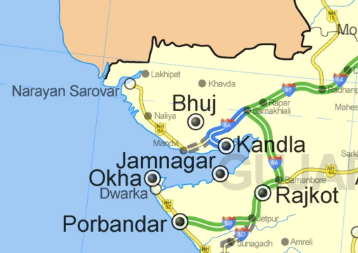
Map symbols are graphic marks that represent real-world geographic phenomena on a reduced representation of the earth.[1] Both shapes and colors are used to create these symbols on maps.[1] A map legend provides the key to understanding all symbols used on a particular map.[1]
Quick Facts
- Field
- Cartography
- Purpose
- Declare existence
- show location
- visualize attributes
- add aesthetic appeal
- establish visual hierarchy
- Visual variables
- Position
- size
- shape
- value
- color
- orientation
- texture/grain
- Symbol types
- Iconic
- functional
- conceptual
- conventional
- ad hoc
- Key concept
- Visual variables (size, shape, color hue, value, saturation, orientation, pattern)
- Semiotic categories
- Iconic
- functional
- conceptual
- conventional
- ad hoc symbols
- Ontological forms
- Objects and masses
Facts from the source article.
Key facts and history
Symbols represent geographic phenomena that exist in various spatial forms.[2] Different symbol types portray different spatial forms, categorized by ontological form and dimensionality.[2] A symbol's dimensionality may differ from the real-world feature due to cartographic generalization for purpose and scale.[3] Many symbols also visualize properties or attributes of a phenomenon, not just its location and shape.[4]
Properties are usually categorized using Stanley Smith Stevens's classification system or a revision like Chrisman's.[4] Animated, haptic, and sound-based maps have also prompted analogous sets of controllable variables.[5] The geometric primitive and visual symbol chosen for a map feature depend on how many spatial dimensions are required to represent that phenomenon.[6] In his 1967 work "Sémiologie Graphique," Jacques Bertin introduced the idea of visual variables, listing seven main types: position, size, shape, value, color, orientation, and texture/grain.[7]
Later cartographers have revised and added to Bertin's original list of visual variables.[7]
What the cited sources add
The Compass Dude source states that without symbols, maps would not exist.[1] According to semiotics, map symbols are "read" when a user connects the graphic mark (sign), a concept (interpretant), and a real-world feature (object or referent).[8] Principles of cognition explain why certain map symbols work, though past mapmakers did not care why they worked.[9] Visual variables can convey information, provide contrast, establish figure-ground contrast and visual hierarchy, or add aesthetic appeal.[10]
Thematic symbols, which directly convey the map's subject, are designed to be visually prominent.[11] A map legend typically excludes symbols that are self-explanatory or unrelated to the map's theme.[11]
References
- "Map Symbols", Compass Dude, n.d.. facts only, no text reused. compassdude.com
- Wikipedia, "Map symbol" (CC BY-SA 4.0), which cites: Krygier, "Making Maps: A Visual Guide to Map Design for GIS", Guilford Press, 2005 (original not read by us) en.wikipedia.org
- Wikipedia, "Map symbol" (CC BY-SA 4.0), which cites: White, "Geographic Information Science & Technology Body of Knowledge", 2017 (original not read by us) en.wikipedia.org
- Wikipedia, "Map symbol" (CC BY-SA 4.0), which cites: Chrisman, "Rethinking Levels of Measurement for Cartography", Cartography and Geographic Information Science, 1998, p. 231–242; White, "Geographic Information Science & Technology Body of Knowledge", 2017 (original not read by us) en.wikipedia.org
- Wikipedia, "Map symbol" (CC BY-SA 4.0), which cites: Dibiase, "Animation and the Role of Map Design in Scientific Visualization", Cartography and Geographic Information Systems, 1992, p. 201–214; MacEachren, A.M. (1994). Some truth with maps: A primer on symbolization and design. Association of American Geographers.; Griffin, "Feeling It Out: The Use of Haptic Visualization for Exploratory Geographic Analysis", Cartographic Perspectives, 2001, p. 12–29; Krygier, J. B. (1994). Sound and geographic visualization. In Visualization in Modern Cartography. A. M. MacEachren and D. R. F. Taylor (Eds.) en.wikipedia.org
- Wikipedia, "Map symbol" (CC BY-SA 4.0), which cites: MacEachren, A.M. (1994). Some truth with maps: A primer on symbolization and design. Association of American Geographers. (original not read by us) en.wikipedia.org
- Wikipedia, "Map symbol" (CC BY-SA 4.0), which cites: Jacque Bertin, Sémiologie Graphique. Les diagrammes, les réseaux, les cartes. With Marc Barbut [et al.]. Paris : Gauthier-Villars. (Translation 1983. Semiology ; "Visual Variables – InfoVis:Wiki", infovis-wiki.net; Tyner, J. A. (2010). Principles of map design. New York: The Guilford Press. (original not read by us) en.wikipedia.org
- Wikipedia, "Map symbol" (CC BY-SA 4.0), which cites: MacEachren, Alan (1995) How Maps Work: Representation, visualization, and design, New York: Guilford Press; Dent, "Cartography : thematic map design", McGraw-Hill Higher Education, 1999 (we also read that source) en.wikipedia.org
- Wikipedia, "Map symbol" (CC BY-SA 4.0), which cites: Olson, "Cognitive Cartographic Experimentation", The Canadian Cartographer, 1979, p. 34–44 (original not read by us) en.wikipedia.org
- Wikipedia, "Map symbol" (CC BY-SA 4.0), which cites: Roth, "International Encyclopedia of Geography", 2017, p. 1–11; White, "Geographic Information Science & Technology Body of Knowledge", 2017 (we also read that source) en.wikipedia.org
- Wikipedia, "Map symbol" (CC BY-SA 4.0), which cites: "Map Symbols", Compass Dude, n.d. (we also read that source) en.wikipedia.org
Each numbered sentence above was checked against the source it cites before publication. Sentences citing Wikipedia adapt text from the English Wikipedia article Map symbol (contributors), used under CC BY-SA 4.0; this entry is available under the same licence. Other sources were used for facts only; no text or images are copied from them.
More in Maps & Their Symbols
Sources
Compiled from Wikipedia and the sources listed below. Text from Wikipedia is available under CC BY-SA 4.0; this entry is adapted from it.
- Wikipedia: Map symbol (CC BY-SA 4.0).
Spotted an error? Know more?
Reader corrections go straight into our review queue. Suggest an edit · How this site is sourced