Bryce Canyon
A collection of hoodoo-filled amphitheaters on the Paunsaugunt Plateau.

via Wikipedia: Bryce Canyon National Park · see source
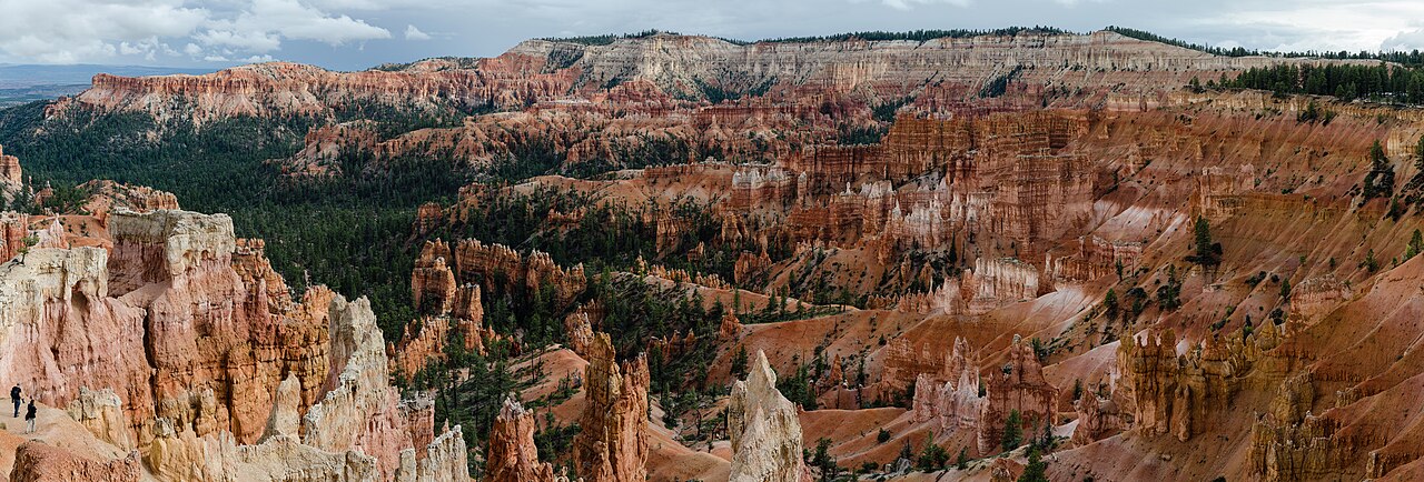
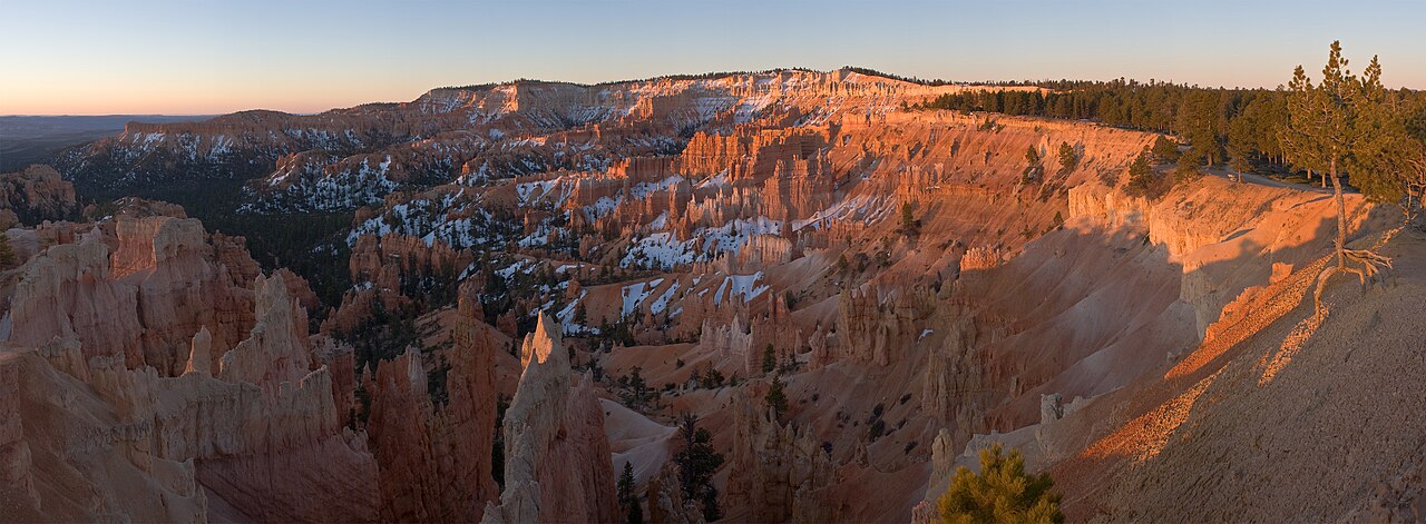
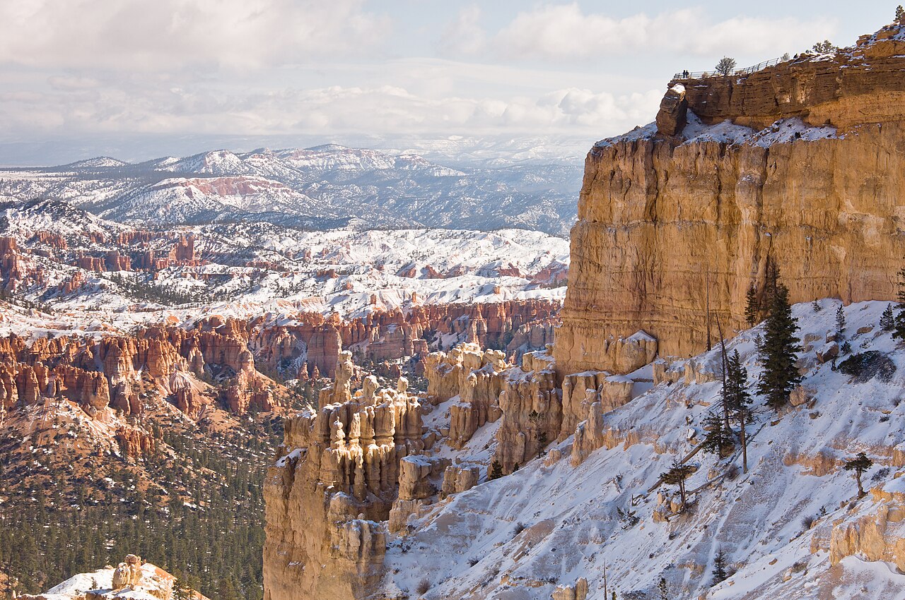
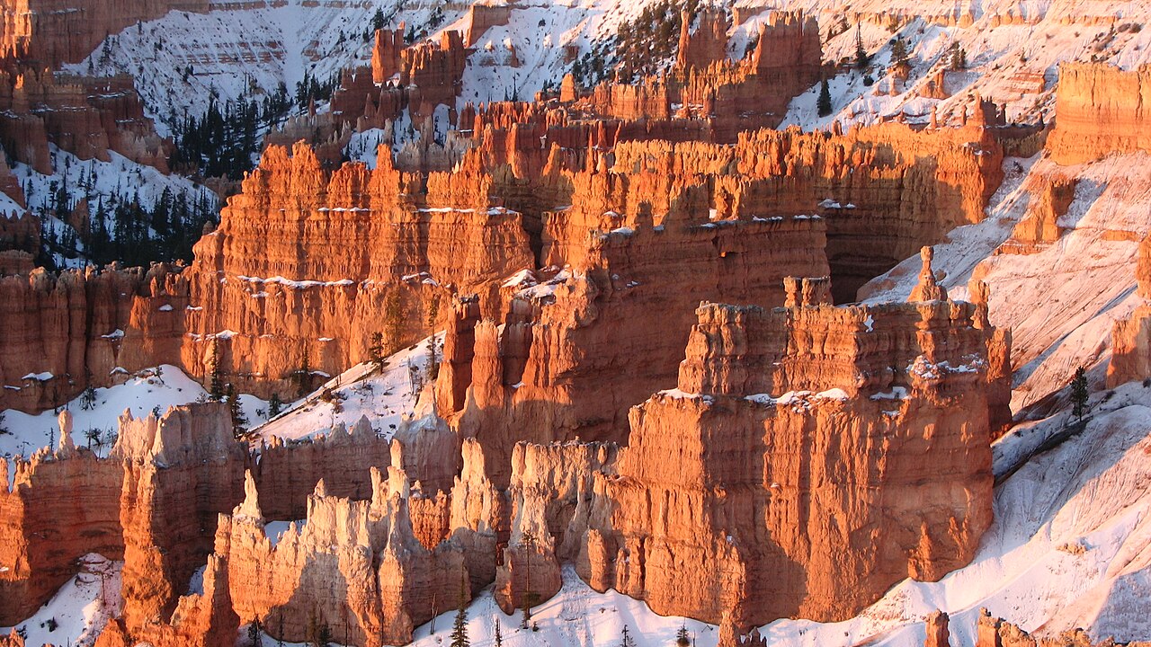
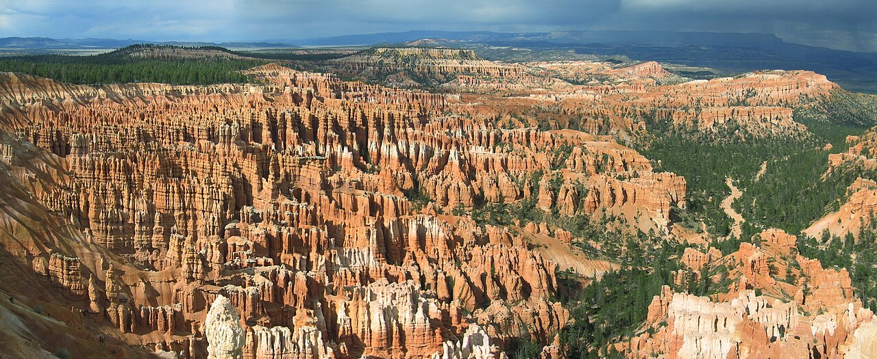
Bryce Canyon National Park sits in southwestern Utah. Its main attraction, Bryce Canyon, is actually a series of giant natural amphitheaters carved into the eastern edge of the Paunsaugunt Plateau. The park is known for its hoodoos—colorful rock spires created by frost and stream erosion of ancient lake and riverbed sediments. These rocks display shades of red, orange, and white. Compared to nearby Zion National Park, Bryce is both smaller and higher in elevation, with its rim ranging from 8,000 to 9,000 feet.
The park covers 35,835 acres in parts of Garfield and Kane Counties. Mormon pioneers settled the area in the 1850s, and it was named for Ebenezer Bryce, who homesteaded there in 1874. President Warren G. Harding designated it a national monument in 1923, and Congress made it a national park in 1928. Bryce Canyon receives far fewer visitors than Zion or Grand Canyon, largely due to its remote location—nearly 2.5 million people visited in 2024. The park spans three life zones, supporting 1,000 plant species, 59 mammal species, and at least 100 bird species.
Geographically, the park lies on the Colorado Plateau, straddling the southeastern edge of the Paunsaugunt Plateau west of the Paunsaugunt Faults. Visitors arrive at the plateau rim and look over into a valley containing the fault and the Paria River. The Kaiparowits Plateau lies opposite. Because erosion here didn't start from a central stream, Bryce Canyon isn't a true canyon. Instead, headward erosion carved large amphitheaters from Cenozoic-era rocks, creating hoodoos up to 200 feet tall. These amphitheaters stretch over 20 miles north to south; the largest, Bryce Amphitheater, is 12 miles long, 3 miles wide, and 800 feet deep. A similar formation at higher elevation exists at Cedar Breaks National Monument, 25 miles west. Rainbow Point, at 9,105 feet, is the park's highest point and the end of an 18-mile scenic drive. From there, views include the Aquarius Plateau, Bryce Amphitheater, the Henry Mountains, and the Vermilion and White Cliffs. Yellow Creek, exiting the park in the northeast, is the lowest point at 6,620 feet.
The climate is continental, with warm, dry summers. The visitor center's plant hardiness zone is 5b, with an average extreme minimum of -10°F. Bryce Canyon is cooler and wetter than Zion, receiving 15 to 18 inches of precipitation yearly. January averages 9°F, July averages 83°F, with extremes from -30°F to 97°F. The record high was 98°F in July 2002; the record low was -28°F in December 1972.
People have lived in the area for at least 10,000 years. Basketmaker Anasazi artifacts thousands of years old were found south of the park, along with Pueblo-period Anasazi and Fremont culture items from up to the mid-12th century. The Paiute arrived around the time other groups left, hunting, gathering, and cultivating plants. They believed hoodoos were the Legend People turned to stone by the trickster Coyote for their bad deeds, calling them *Anka-ku-was-a-wits*, meaning "red painted faces."
European Americans first explored the area in the late 1700s and early 1800s. Mormon scouts came in the 1850s to assess it for farming and settlement. Major John Wesley Powell led the first major scientific expedition in 1872, surveying the Sevier and Virgin River area. His mapmakers used many Paiute place names. Mormon pioneers then attempted to settle east of Bryce Canyon along the Paria River.
- Established as national monument
- June 8, 1923
- Established as national park
- February 25, 1928
- Area
- 35,835 acres (55.992 sq mi; 14,502 ha; 145.02 km²)
- Elevation range
- 6,620 to 9,105 feet (2,020 to 2,775 m)
- Annual visitors (2024)
- Almost 2.5 million
- Location
- Garfield County and Kane County, southwestern Utah
Verified Timeline
Lore & Background
The area was settled by Mormon pioneers in the 1850s and named after Ebenezer Bryce, who homesteaded there in 1874. Bryce grazed cattle inside what are now park borders and built a road to the plateau for firewood and timber. Other settlers began calling the canyon at the end of the road 'Bryce's Canyon', and the name stuck. Drought, overgrazing, and flooding eventually drove most settlers, including the Bryce family, to abandon the area by 1880. The Paiute people, who moved into the area around the time other cultures left, developed a mythology surrounding the hoodoos, believing they were the Legend People whom the trickster Coyote turned to stone due to their bad deeds. One older Paiute said his culture called the hoodoos Anka-ku-was-a-wits, which is Paiute for 'red painted faces'.
Reader's Guide
Bryce Canyon National Park is significant for its unique hoodoo formations, which are up to 200 feet high and result from headward erosion of Cenozoic-aged rocks. The park spans three life zones and contains 1,000 plant species, 59 mammal species, and at least 100 bird species. It receives substantially fewer visitors than Zion or Grand Canyon national parks, largely due to its more remote location. The park was originally designated a national monument by President Warren G. Harding in 1923 and redesignated a national park by Congress in 1928. Its climate is continental with warm, dry summers, and it receives 15 to 18 inches of precipitation per year. The park's highest point is Rainbow Point at 9,105 feet, and the lowest is Yellow Creek at 6,620 feet.
Did You Know?
- Bryce Canyon is not a canyon; it is a collection of giant natural amphitheaters formed by headward erosion.
- The park's hoodoos are up to 200 feet (60 m) high.
- The park was originally designated a national monument by President Warren G. Harding on June 8, 1923.
- The Paiute called the hoodoos 'Anka-ku-was-a-wits,' meaning 'red painted faces.'
- The park's highest point is Rainbow Point at 9,105 feet (2,775 m), and its lowest is Yellow Creek at 6,620 feet (2,020 m).
The Architecture of Stone — Hoodoos and Amphitheaters
Bryce Canyon's most arresting feature is its forest of hoodoos, towering rock pinnacles that can climb to 200 feet in height. Contrary to what the name suggests, no single river carved this landscape; the term 'canyon' is technically a misnomer. Instead, headward erosion slowly hollowed out enormous amphitheater-shaped bowls into the Cenozoic-aged sedimentary rock of the Paunsaugunt Plateau. Frost weathering and stream erosion acted together on ancient river and lake bed deposits to sculpt the pinnacles into their current forms. A chain of these amphitheaters stretches more than 20 miles from north to south across the park. The largest, Bryce Amphitheater, spans 12 miles in length, 3 miles in width, and plunges 800 feet deep. The exposed rock faces display vivid reds, oranges, and whites, creating a chromatic spectacle unlike most other American landscapes. A comparable formation of hoodoos and amphitheaters sits at Cedar Breaks National Monument, roughly 25 miles to the west on the Markagunt Plateau, though at a still higher elevation.
Ten Thousand Years of Stories
Long before any European American set foot in the region, people had inhabited the Paunsaugunt Plateau for at least 10,000 years. Archaeological surveys have uncovered Basketmaker Anasazi artifacts thousands of years old south of the park, along with later Pueblo-period and Fremont culture remains dating to the mid-12th century. The Paiute people arrived as those earlier cultures departed, and they wove the hoodoos into their mythology, believing the stone pillars were the 'Legend People' turned to rock by the trickster Coyote as punishment for their misdeeds. An elder Paiute described the formations as 'Anka-ku-was-a-wits,' a phrase meaning 'red painted faces.' In the 1850s, Mormon scouts assessed the area's agricultural and grazing potential, and in 1872, Major John Wesley Powell led the first major scientific survey of the region, with his mapmakers borrowing many Paiute place names. In 1874, Scottish immigrant Ebenezer Bryce and his wife Mary homesteaded just below the main amphitheater, grazing cattle among the hoodoos — a spot he reportedly called 'a helluva place to lose a cow.'
A High-Altitude World of Seasons and Species
Perched between 8,000 and 9,000 feet above sea level, Bryce Canyon occupies a continental climate zone (Köppen Dsb) that delivers warm, dry summers and cold winters with meaningful precipitation — 15 to 18 inches annually, noticeably more than its neighbor Zion. Average temperatures swing from a January low of 9°F to a July high of 83°F, though extremes have recorded from −28°F in December 1972 to 98°F in July 2002. The visitor center sits in plant hardiness zone 5b, with an average annual extreme minimum of −10.0°F. Despite the harsh conditions, the park spans three distinct life zones, supporting forests and meadows that harbor extraordinary biodiversity: roughly 1,000 plant species, 59 mammal species, and at least 100 bird species. This ecological richness is packed into a relatively compact 35,835-acre area straddling Garfield and Kane counties, making it one of the most species-dense landscapes in the American West.
A Remote Jewel on the Colorado Plateau
Bryce Canyon National Park occupies 35,835 acres in southwestern Utah, perched on the southeastern edge of the Paunsaugunt Plateau — a name derived from the Paiute phrase meaning 'home of the beaver.' The park sits about 50 miles northeast of Zion National Park and roughly 1,000 feet higher in elevation. Its remoteness has kept visitor numbers well below those of Zion (nearly 4.3 million in 2016) or the Grand Canyon (almost 6 million in 2016); in 2024, Bryce welcomed almost 2.5 million visitors. The 18-mile scenic drive culminates at Rainbow Point, the park's highest spot at 9,105 feet, offering sweeping views of Aquarius Plateau, Bryce Amphitheater, the Henry Mountains, and the Vermilion and White Cliffs. The lowest point, where Yellow Creek exits the park in the northeast, drops to 6,620 feet. Originally designated a national monument by President Harding in 1923, the area was elevated to full national park status by Congress in 1928.
Common Misconceptions (Editorial)
Many people mistakenly assume that Bryce Canyon is a true canyon, like the Grand Canyon; in reality, it is a series of giant natural amphitheaters formed by headward erosion, not a river-carved canyon. Another common misconception is that the park is large and low-elevation like nearby Zion National Park, but Bryce Canyon is much smaller and sits at a much higher elevation, with its rim varying from 8,000 to 9,000 feet.
Why It Matters (Editorial)
Bryce Canyon matters because its otherworldly landscape of hoodoos—up to 200 feet tall—offers a rare glimpse into the delicate interplay of frost, water, and time. The enduring presence of Paiute mythology, which sees these stone formations as the "Legend People" turned to stone, reminds us that this place has inspired wonder and meaning for centuries, making it a site of both natural and cultural significance.
Gallery

Frequently Asked Questions
What is Bryce Canyon, actually?
Despite the name, Bryce Canyon is not a canyon in the traditional sense. It is a series of enormous natural amphitheaters carved into the eastern rim of the Paunsaugunt Plateau in southwestern Utah.
What are hoodoos and why are they famous here?
Hoodoos are the park's signature rock spires, sculpted over millennia by frost weathering and stream erosion acting on sedimentary layers. Their striking red, orange, and white coloration makes the landscape one of the most visually dramatic in the U.S.
How does Bryce Canyon compare to nearby Zion National Park?
Bryce Canyon is far smaller, covering roughly 35,835 acres, yet it sits at a considerably higher elevation, ranging from about 6,620 to 9,105 feet above sea level. That altitude difference gives it a noticeably cooler, alpine feel compared to Zion's desert canyon.
When was Bryce Canyon established as a national park?
The area was first protected as a national monument on June 8, 1923, and then upgraded to full national park status on February 25, 1928. It is located in Garfield and Kane counties in Utah.
How popular is Bryce Canyon with visitors?
The park welcomed nearly 2.5 million visitors in 2024, making it one of Utah's most heavily visited outdoor destinations despite its compact footprint.
More in US National Parks 1-22
Spotted an error? Know more?
This is a living reference — every entry is fact-audited, and reader corrections feed straight into our audit queue. Suggest an edit · See this site's audit record