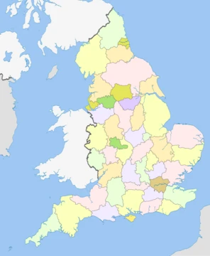
Rutland
England's smallest historic county, rich in rural charm and Norman heritage.
Rutland is a ceremonial county in the East Midlands of England. It borders Leicestershire to the north and west, Lincolnshire to the north-east, and Northamptonshire to the south-west. Rutland has an area of 382 km2 and had an estimated population of in , the second-smallest ceremonial county population after the City of London. The county is rural, and the only towns are Oakham in the west and Uppingham in the south; its villages include Cottesmore in the north and Ketton in the east. For local government purposes Rutland is a unitary authority area. The county was the smallest of the historic counties of England.
- area
- 382 km² (147 sq mi)
- population_2024
- 41,443
- highest_point
- 197 m (646 ft) at Cold Overton Park
- lowest_point
- 17 m (56 ft) near Belmesthorpe
- county_town
- Oakham
- established_as_county
- First mentioned in 1179
- unitary_authority_since
- 1997
Quick Facts
- Official Name
- Rutland
- Region
- East Midlands
- Established Date
- 1 April 1997
- Established By
- Local Government Commission for England
- Origin
- Ancient
- Lord Lieutenant Office
- Lord-Lieutenant of Rutland
- Lord Lieutenant Name
- Sarah Furness
- High Sheriff Office
- High Sheriff of Rutland
- Ethnicity
- 94.8% White, 1.8% Mixed, 1.5% Asian, 1.3% Black, 0.5% Other
- Unitary Council
- Rutland County Council
- Admin Hq
- Oakham
- Area Council Km2
- 382
Facts from the source article.
Lore & Background
Rutland is referred to as Roteland in the Domesday Book (completed in 1086). The name means 'land belonging to Rōta', with Rōta being an Old English personal name that meant 'the pleasant or cheerful one'. The Earl of Rutland and Duke of Rutland are titles in the peerage of England held in the Manners family, derived from the historic county of Rutland. The Earl of Rutland was elevated to the status of Duke in 1703 and the titles were merged. The family seat is Belvoir Castle, Leicestershire. The office of High Sheriff of Rutland was instituted in 1129, and there has been a Lord Lieutenant of Rutland since at least 1559. Oakham Castle was built –1190 and is 'one of the nation’s best-preserved Norman buildings' and is a Grade I listed building. By the 19th century it had been divided into the hundreds of Alstoe, East Rutland, Martinsley, Oakham and Wrandike. Rutland covered parts of three poor law unions and rural sanitary districts (RSDs): those of Oakham, Uppingham and Stamford. The registration county of Rutland contained the entirety of Oakham and Uppingham RSDs, which included several parishes in Leicestershire and Northamptonshire – the eastern part in Stamford RSD was included in the Lincolnshire registration county. Under the Poor Laws, Oakham Union workhouse was built in 1836–37 at a site to the north-east of the town, with room for 100 paupers. The building later operated as the Catmose Vale Hospital, and now forms part of the Oakham School. In 1894, under the Local Government Act 1894, the rural sanitary districts were partitioned along county boundaries to form three rural districts. The part of Oakham and Uppingham RSDs in Rutland formed the Oakham Rural District and Uppingham Rural District, with the two parishes from Oakham RSD in Leicestershire becoming part of the Melton Mowbray Rural District, the nine parishes of Uppingham RSD in Leicestershire becoming the Hallaton Rural District, and the six parishes of Uppingham RSD in Northamptonshire becoming Gretton Rural District. Meanwhile, that part of Stamford RSD in Rutland became the Ketton Rural District. Oakham Urban District was created from Oakham Rural District in 1911. It was subsequently abolished in 1974. Rutland was included in the 'East Midlands General Review Area' of the 1958–67 Local Government Commission for England. Draft recommendations would have seen Rutland split, with Ketton
Reader's Guide
The geography of Rutland is characterised by low, rolling hills, the highest of which is a 197 m point in Cold Overton Park. Rutland Water was created in the centre of the county in the 1970s; the reservoir is a nature reserve that serves as an overwintering site for wildfowl and a breeding site for ospreys. There is little evidence of Prehistoric settlement in Rutland; however, a Roman mosaic and probable farming complex is located west of the village of Ketton. The area was settled by the Angles from the 5th century and later formed part of the kingdom of Mercia. Rutland was first mentioned as a distinct county in 1179, and during the High Middle Ages much of it was forested and used as hunting grounds. The wool trade was important during the 16th century. The older buildings in the county are built from local limestone or ironstone, and many have roofs of Collyweston stone slate or thatch. Rutland's main industry is agriculture, and there is a limestone quarry near Ketton. The particular geology of the area has given its name to the Rutland Formation, which was formed from muds and sand carried down by rivers and occurring as bands of different colours, each with many fossil shells at the bottom. The formation has also preserved a well-preserved specimen of the sauropod dinosaur Cetiosaurus oxienensis at Great Casterton, currently on display at Leicester Museum & Art Gallery. At the bottom of the Rutland Formation is a bed of dirty white sandy silt. Under the Rutland Formation is a formation called the Lincolnshire limestone. The best exposure of this limestone (and also the Rutland Formation) is at the Ketton Cement Works quarry just outside Ketton. Rutland is dominated by Rutland Water, a large artificial lake formerly known as Empingham Reservoir, in the middle of the county, which is almost bisected by the Hambleton Peninsula. The west part is in the Vale of Catmose. Rutland Water, when construction started in 1971, became the largest man-made lake in Europe; construction was completed in 1975, and filling the lake took a further four years. This has been voted Rutland's favourite tourist attraction. The highest point of the county is at Cold Overton Park (historically part of Flitteriss Park) at 197 m (646 ft) above sea level close to the west border (OS Grid reference: SK8271708539). The lowest point is close to the east border, in secluded farmland
Did You Know?
- Rutland is the smallest historic county of England.
- Rutland Water was the largest man-made lake in Europe when it was completed in 1975.
- The name Rutland comes from Old English, meaning 'land belonging to Rōta'.
- Oakham Castle is one of the nation’s best-preserved Norman buildings.
More in English Counties 1-24
Spotted an error? Know more?
This is a living reference — every entry is fact-audited, and reader corrections feed straight into our audit queue. Suggest an edit · See this site's audit record