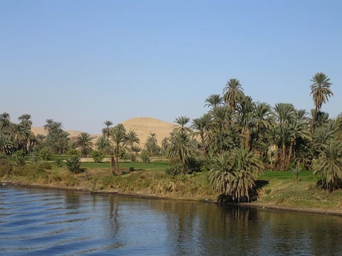
Paraná River
Second-longest South American river, vital for power and navigation.

via Wikipedia: Paraná River · see source
The Paraná River flows for roughly 4,880 kilometers through Brazil, Paraguay, and Argentina, making it the second-longest river in South America after the Amazon. It joins the Paraguay River, then later the Uruguay River, to create the Río de la Plata, which empties into the Atlantic Ocean. The Venetian explorer Sebastian Cabot, sailing for Spain, became the first European to navigate the river in 1526. In 2021, a drought caused water levels to drop to their lowest point in 77 years.
The river’s name comes from the Guarani language, where “para-” or “parana-” elements appear in many regional river names, meaning “river” or “sea.” Attempts to give this specific river a more precise translation, such as “kin of the sea,” have been dismissed.
The Paraná begins at the meeting of the Paranaiba and Rio Grande rivers in southern Brazil. From there, it flows southwest for about 619 kilometers to the site of the former Guaíra Falls (Sete Quedas), a series of seven cascades once compared to Iguazu Falls. These were flooded after the Itaipu Dam began operating in 1984. For the next 200 kilometers, the river forms the border between Paraguay and Brazil until it meets the Iguazu River. Upstream from that confluence, the Itaipu Dam—the world’s third-largest hydroelectric plant, after China’s Three Gorges and Baihetan dams—creates a large, shallow reservoir.
After merging with the Iguazu, the Paraná becomes the natural boundary between Paraguay and Argentina. From Encarnación, Paraguay, one can see downtown Posadas, Argentina, across the river. The river flows south for about 468 kilometers, then gradually turns west for another 820 kilometers before meeting the Paraguay River, its largest tributary. Before that confluence, the Yacyretá Dam—a joint project between Paraguay and Argentina—forms another massive reservoir, which has caused problems for low-lying areas of Encarnación, flooding parts of the city and displacing poorer residents and merchants.
From the Paraguay River junction, the Paraná turns south again for roughly 820 kilometers through Argentina, curving east near Rosario for the final stretch of less than 500 kilometers. It then merges with the Uruguay River to form the Río de la Plata, which flows into the Atlantic. Downstream from Diamante, Entre Ríos, the river splits into multiple arms, creating the Paraná Delta.
The Paraná’s drainage basin covers much of south-central South America, including all of Paraguay, much of southern Brazil, northern Argentina, and southeastern Bolivia. If the Uruguay River is counted as a tributary, the watershed also covers most of Uruguay. The volume of water reaching the Atlantic through the Río de la Plata is roughly equal to that of the Mississippi River delta. Major cities within this basin include São Paulo, Buenos Aires, Rosario, Asunción, Brasília, and La Plata.
The river and its tributaries support fishermen who rely on it for income and food. Commercially important fish like surubí and sábalo are harvested for local consumption or export. The Paraná Delta is also a top destination for bird-watching. Much of the river is navigable as part of the Paraná–Paraguay and Tietê–Paraná waterways, linking inland cities in Argentina and Paraguay to the ocean and providing deepwater ports. Large hydroelectric dams have blocked shipping to upstream cities, but their economic benefits offset this loss. The Yacyretá and Itaipu dams have made Paraguay the world’s largest exporter of hydroelectric power. Water level measurements, taken since 1904 for oceangoing ships, correlate with the sun’s solar cycle.
A dispute over navigation rights in 1966 arose partly because Argentina wanted to build a bridge across the Paraná near Asunción or further south, while Paraguay opposed it unless navigation issues were settled. Argentina also sought an agreement for a major hydroelectric facility at the Apipé Rapids. Paraguay, meanwhile, had already completed the Acaray Dam, which met the country’s energy needs for ten to fifteen years and produced a surplus for export.
- length
- 4,880 km (3,030 mi)
- source
- Confluence of the Paranaíba and Rio Grande rivers in southern Brazil
- mouth
- Río de la Plata, Atlantic Ocean
- major_tributaries
- Paraguay River, Uruguay River, Iguazu River
- major_dams
- Itaipu Dam, Yacyretá Dam
- first_european_explorer
- Sebastian Cabot (1526)
- navigable_waterways
- Paraná–Paraguay Waterway, Tietê–Paraná Waterway
Verified Timeline
Lore & Background
The Paraná River's course is formed at the confluence of the Paranaiba and Rio Grande rivers in southern Brazil. From the confluence the river flows in a generally southwestern direction for about 619 km (385 mi) before encountering the city of Saltos del Guaira, Paraguay. This was once the location of the Guaíra Falls (Sete Quedas waterfalls), where the Paraná fell over a series of seven cascades. This natural feature was said to rival the world-famous Iguazu Falls to the south. The falls were flooded, however, by the construction of the Itaipu Dam, which began operating in 1984. For approximately the next 200 km (120 mi), the Paraná flows southward and forms a natural boundary between Paraguay and Brazil until the confluence with the Iguazu River. Further upstream from this confluence, however, the river is dammed by the Itaipu Dam, the third largest hydroelectric power plant in the world (following the Three Gorges Dam and the Baihetan Dam, both in the People's Republic of China), creating a massive, shallow reservoir behind it. After merging with the Iguazu, the Paraná becomes the natural border between Paraguay and Argentina. The river continues its general southward course for about 468 km (291 mi) before making a gradual turn to the west for another 820 km (510 mi), and then encounters the Paraguay River, the largest tributary along the course of the river. Before this confluence, the river passes through a second major hydroelectric project, the Yacyretá Dam, a joint project between Paraguay and Argentina. The massive reservoir formed by the project has been the source of a number of problems for people living along the river, most notably the poorer merchants and residents in the low-lying areas of Encarnación, a major city on the southern border of Paraguay. River levels rose dramatically upon completion of the dam, flooding out large sections of the city's lower areas. From the confluence with the Paraguay River, the Paraná again turns to the south for another approximately 820 km (510 mi) through Argentina, making a slow turn back to the east near the city of Rosario for the final stretch of less than 500 km (310 mi) before merging with the Uruguay River to form the Río de la Plata. This flows into the Atlantic Ocean. During the part of its course downstream from the city of Diamante, Entre Ríos, it splits into several arms and it forms the Paraná Delta.
Reader's Guide
Together with its tributaries, the Rio Paraná forms a massive drainage basin that encompasses much of the south-central part of South America, essentially including all of Paraguay, much of southern Brazil, northern Argentina, and the south-eastern part of Bolivia. If the Uruguay River is counted as a tributary to the Paraná, this watershed extends to cover most of Uruguay as well. The volume of water flowing into the Atlantic Ocean through the Río de la Plata roughly equals the volume at the Mississippi River delta. This watershed contains a number of large cities, including São Paulo, Buenos Aires, Rosario, Asunción, Brasília, and La Plata. The Paraná and its tributaries provide a source of income and daily sustenance for fishermen who live along its banks. Some of the species of fish (such as the surubí and the sábalo) are commercially important, and they are exploited for heavy internal consumption or for export. The Paraná River delta ranks as one of the world's greatest bird-watching destinations. Much of the length of the Paraná is navigable, as part of the Paraná–Paraguay Waterway and the Tietê–Paraná Waterway. The river serves as an important waterway linking inland cities in Argentina and Paraguay with the ocean, providing deepwater ports in some of these cities. The construction of enormous hydroelectric dams along the river's length has blocked its use as a shipping corridor to cities further upstream, but the economic impact of those dams offsets this. The Yacyretá Dam and the Itaipu Dam on the Paraguay border have made the small, largely undeveloped nation of Paraguay the world's largest exporter of hydroelectric power. Due to its use for oceangoing ships, measurements of the water tables extend back to 1904. The data correlates with the Sun's solar cycle.
Did You Know?
- The first European to go up the Paraná River was the Venetian explorer Sebastian Cabot, in 1526, while working for Spain.
- A drought hit the river in 2021, causing a 77-year low.
- The Guaíra Falls (Sete Quedas waterfalls) were flooded by the construction of the Itaipu Dam, which began operating in 1984.
- The Itaipu Dam is the third largest hydroelectric power plant in the world, following the Three Gorges Dam and the Baihetan Dam.
- Measurements of the water tables extend back to 1904 and correlate with the Sun's solar cycle.
Frequently Asked Questions
Who is the Paraná River?
The Paraná is South America's second-longest river, stretching roughly 4,880 kilometers as it threads through Brazil, Paraguay, and Argentina. It is born at the confluence of the Paranaíba and Rio Grande rivers in southern Brazil.
What is the Paraná River's role in the region?
It functions as a backbone for commercial navigation, a powerhouse for hydroelectric generation, and a productive fishing corridor that sustains communities across three nations. Its vast drainage basin also feeds major cities including São Paulo, Buenos Aires, and Asunción.
How does the Paraná River's journey end?
After nearly 3,030 miles of flowing through three countries, the Paraná finally discharges into the Río de la Plata estuary, from which its waters reach the Atlantic Ocean. This broad estuary marks the river's ultimate terminus.
What major dams are built on the Paraná River?
The river hosts two of the world's largest hydroelectric installations: the Itaipu Dam on the Brazil–Paraguay border and the Yacyretá Dam between Paraguay and Argentina. Together they generate a staggering share of electricity for the surrounding countries.
Who was the first European to explore the Paraná River?
English navigator Sebastian Cabot charted the waterway in 1526, making him the first European to document the river. His account helped draw later colonial and commercial attention to the region.
More in Rivers Of The World 1-20
Spotted an error? Know more?
This is a living reference — every entry is fact-audited, and reader corrections feed straight into our audit queue. Suggest an edit · See this site's audit record