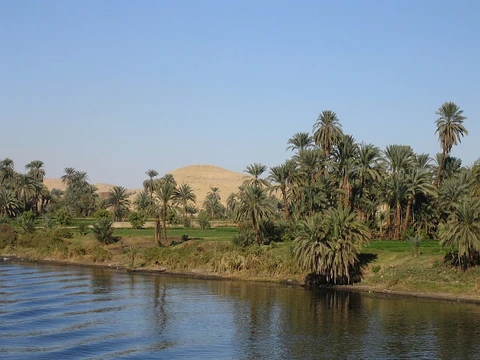
Madeira River
Biggest tributary of the Amazon, known pre-colonially as Cuyari, vital for navigation and grain exports.

via Wikipedia: Madeira River · see source
The Madeira River, known in Portuguese as Rio Madeira, is a significant South American waterway. Its length is roughly 1,450 kilometers (900 miles), while the combined Madeira-Mamoré system stretches between 3,250 and 3,380 kilometers (2,020 to 2,100 miles), depending on who measures and how. As the Amazon’s largest tributary, it contributes about 15% of that river’s total water volume. An old map by Emanuel Bowen, dated 1747 and kept in the David Rumsey Map Collection, labels it with its pre-colonial Indigenous name: Cuyari. The Portuguese called it Madeira, or “Wood River,” and it forms where two major rivers converge near its outlet. Historically, this was the route the Topinambes people used to reach the Amazon River.
In terms of climate, average yearly rainfall across the Madeira’s vast basins ranges from 75 to 300 centimeters (2.5 to 9.8 feet), with the entire upper basin receiving an average of 170.5 centimeters (5.6 feet). Extreme precipitation varies between 49 and 700 centimeters (1.6 to 23 feet). Even just below the point where its headwaters meet, the Madeira ranks among the world’s largest rivers by discharge, with an average annual flow of 18,000 cubic meters per second (640,000 cubic feet per second)—that’s 568 cubic kilometers (136 cubic miles) per year, roughly half the Congo River’s output. As it continues toward the Amazon, its mean discharge swells to 31,200 cubic meters per second (1,100,000 cubic feet per second).
The river’s course collects runoff from the northeastern slopes of the Andes, stretching from Santa Cruz de la Sierra to Cuzco, as well as from the entire southwestern slope of Brazil’s Mato Grosso and the northern slope of the Chiquitos sierras. This catchment area, covering 850,000 square kilometers (330,000 square miles), is slightly larger than the combined area of all its headwaters and nearly equals the size of France and Spain together. Major rivers feeding the Madeira include, from east to west, the Guaporé (or Iténez), the Baures and Blanco, the Itonamas (or San Miguel), the Mamoré, the Beni, and the Madre de Dios (or Mayutata), each reinforced by numerous powerful secondary streams. The climate in the upper basin ranges from humid along the western edge—where the river’s main stem by volume (the Río Madre de Dios and Río Beni) originates—to semi-arid in the southernmost part, where the Andean headwaters of the longest stem (the Río Caine, Río Rocha, Río Grande, and Mamoré) begin.
All the upper branches of the Madeira flow toward the falls across the open, nearly level Mojos and Beni plains. These plains cover 90,000 square kilometers (35,000 square miles), and each year about that area floods to an average depth of one meter (three feet) for three to four months.
From its source at the confluence of the Madre de Dios and Mamoré rivers down to the Abuna River, the Madeira runs northward, forming the border between Bolivia and Brazil. After joining the Abuna, it turns northeast, flowing through Brazil’s Rondônia state. The stretch from the border to Porto Velho has a notable drop in the riverbed and was once unnavigable. Before 2012, the Teotônio and San Antônio falls existed here, with a higher flow rate and greater elevation drop than the more famous Boyoma Falls in Africa. Today, these rapids lie submerged beneath the reservoir of the Santo Antônio Dam. Below Porto Velho, the Madeira meanders northeast through Rondônia and Amazonas states in northwestern Brazil until it meets the Amazon. The Rio Madeira Sustainable Development Reserve, created in 2006, covers 283,117 hectares (2,800 square kilometers; 1,100 square miles) along the river’s north bank, opposite the town of Novo Aripuanã. At its mouth lies Ilha Tupinambaranas, a large marshy area formed by the Madeira’s distributaries.
For navigation, the river rises more than 15 meters (50 feet) during the rainy season, allowing ocean vessels to ascend as far as the falls of San Antonio near Porto Velho, Brazil—1,070 kilometers (660 miles) above its mouth. In the dry months from June to November, however, only craft drawing about 2 meters (7 feet) of water can travel that same distance. The Madeira-Mamoré Railroad once looped 365 kilometers (227 miles) around the unnavigable section to Guajará-Mirim on the Mamoré River, but it is no longer functional, limiting shipping from the Atlantic to Porto Velho. Today, the Madeira is one of the Amazon basin’s busiest waterways, helping export nearly four million tons of grain. These grains are loaded onto barges in Porto Velho, where both Cargill and Amaggi have facilities, then shipped down the Madeira to ports like Itacoatiara (near the Madeira’s mouth on the Amazon’s left bank) or further down the Amazon to Santarém at the Tapajós River’s mouth. From these ports, Panamax-type ships carry the grain—mostly soy and corn—to Europe and Asia. The waterway also transports fuel from the REMAN refinery (Petrobras) in Manaus, the capital of Amazonas, to Porto Velho, supplying Acre, Rondônia, and parts of Mato Grosso mainly with gasoline refined in Manaus. Cargo barges travel the 1,225-kilometer (760-mile) route between Manaus and Porto Velho via the Rio Negro, Amazon, and Madeira, connecting Manaus’s industrial district to the rest of Brazil—since Manaus is landlocked logistically—bringing in raw materials and shipping out products to major consumer centers like São Paulo and Rio de Janeiro. In 2012, cargo on this route totaled 287,835 tons (both directions), while total tonnage shipped on the Madeira that year reached 5,076,014 tons. Two large dams are under construction as part of the IIRSA regional integration project, featuring large ship-locks designed to move oceangoing vessels between the impounded reservoir and the downstream river.
- length
- 1,450 km (900 mi); Madeira-Mamoré estimated near 3,250 km (2,020 mi) or 3,380 km
- discharge
- Mean inter-annual discharge of 18,000 m³/s (640,000 cu ft/s) below confluence; i
- catchment_area
- 850,000 km² (330,000 sq mi), almost equal to France and Spain combined
- tributary_of
- Amazon River
- indigenous_name
- Cuyari
- navigable_length
- 1,070 km (660 mi) above mouth to falls of San Antonio during rainy season
Quick Facts
- Etymology
- Portuguese, "wood river"
- Map Size
- 270
- Subdivision Type1
- Country
- Subdivision Name1
- Bolivia, Brazil
- Subdivision Type5
- Cities
- Subdivision Name5
- Nova Olinda do Norte, Borba, Novo Aripuanã, Manicoré, Humaitá, Porto Velho
- Length
- 1,450 km / 3,250 km Madeira-Mamoré River
- Discharge1 Location
- near mouth
- Discharge1 Min
- 2,346 m3/s
- Discharge1 Avg
- (Period: 1973–1990)31,200 m3/s
- Discharge1 Max
- 52,804 m3/s
- Source1
- Confluence of Madre de Dios and Mamoré
Facts from the source article.
Lore & Background
The Madeira River is formed by two great rivers that join near its mouth. A 1747 map by Emanuel Bowen, held by the David Rumsey Map Collection, calls it the River of Cuyari, the pre-colonial indigenous name. The Portuguese called it Madeira, or the Wood River. It was by this river that the Nation of Topinambes passed into the River Amazon. All of the upper branches of the river Madeira find their way to the falls across the open, almost level Mojos and Beni plains, 90,000 km² of which are yearly flooded to an average depth of about one meter for a period of from three to four months. The river rises more than 15 m during the rainy season, and ocean vessels may ascend it to the falls of San Antonio, near Porto Velho, Brazil, 1,070 km above its mouth; but in the dry months, from June to November, it is only navigable for the same distance for craft drawing about 2 meters of water. The Madeira-Mamoré Railroad runs in a 365 km loop around the unnavigable section to Guajará-Mirim on the Mamoré River, but is not functional.
Reader's Guide
The Madeira River is one of the Amazon basin's most active waterways, and helps export close to four million tons of grains, which are loaded onto barges in Porto Velho, where both Cargill and Amaggi have loading facilities, and then shipped down the Madeira to the ports of Itacoatiara, near the mouth of the Madeira, just upstream on the left bank of the Amazon, or further down the Amazon, to the port of Santarem, at the mouth of the Tapajos River. From these two ports, Panamax-type ships then export the grains - mainly soy and corn - to Europe and Asia. The Madeira waterway is also used to take fuel from the REMAN refinery (Petrobras) in Manaus to Porto Velho, from where the states of Acre, Rondônia and parts of Mato Grosso are supplied mainly with gasoline refined in Manaus. In 2012, the cargo amounted to 287,835 tons (both directions). The total tonnage shipped in 2012 on the Madeira accounted to 5,076,014. Two large dams are under construction as part of the IIRSA regional integration project. The dam projects include large ship-locks capable of moving oceangoing vessels between the impounded reservoir and the downstream river. If the project is completed, more than 4,000 km of waterways upstream from the dams in Brazil, Bolivia, and Peru would become navigable.
Did You Know?
- The Madeira River accounts for about 15% of the water in the Amazon basin.
- A 1747 map by Emanuel Bowen refers to the Madeira by the pre-colonial indigenous name Cuyari.
- The Madeira-Mamoré Railroad runs 365 km around an unnavigable section but is not functional.
- The river rises more than 15 m during the rainy season, allowing ocean vessels to ascend 1,070 km to the falls of San Antonio.
- In 2012, total tonnage shipped on the Madeira accounted to 5,076,014.
Formation & Geographic Significance
The Madeira River stands as the single largest tributary feeding into the Amazon, contributing roughly fifteen percent of the entire basin's water volume. Its name, derived from the Portuguese word for wood, was bestowed by colonial explorers, though long before European contact, indigenous peoples knew it as the Cuyari—a name preserved in a 1747 map by cartographer Emanuel Bowen. The river is born where two major waterways, the Madre de Dios and the Mamoré, converge, and from that point it stretches approximately 1,450 kilometers before emptying into the Amazon. When measured as part of the combined Madeira-Mamoré system, the total length reaches roughly 3,250 to 3,380 kilometers, depending on the surveying methodology employed. The catchment area draining into the upper reaches spans an astonishing 850,000 square kilometers—nearly the combined land area of France and Spain—collecting waters from the Andean slopes, the Mato Grosso highlands, and the Chiquitos sierras before funneling them into a single powerful current.
Hydrology & Seasonal Dynamics
The Madeira's hydrological power is staggering. Just below the confluence that gives the river its name, its mean annual discharge reaches approximately 18,000 cubic meters per second, a volume equivalent to roughly half the flow of Africa's Congo River. As the water travels downstream toward the Amazon, additional tributaries push that figure up to 31,200 cubic meters per second. Rainfall across the great basins feeding the system varies enormously, from as little as 75 centimeters to as much as 300 centimeters annually, with the upper Madeira basin averaging around 170 centimeters. The seasonal rhythm is dramatic: during the wet months, the river swells by more than fifteen meters, transforming the vast Mojos and Beni plains—nearly 90,000 square kilometers of open, nearly level terrain—into a temporary lake averaging about one meter in depth for three to four months each year. This pulse of water sustains the ecosystem and shapes every human activity along the river's banks.
Navigation & Economic Lifeline
For centuries, the Madeira has served as a critical artery for trade and transport in western Brazil and eastern Bolivia. During the rainy season, ocean-going vessels can push upstream nearly 1,070 kilometers to the rapids near Porto Velho, while in the dry months from June through November, only shallow-draft craft of about two meters can manage the same stretch. The historic Madeira-Mamoré Railroad, a 365-kilometer loop bypassing the unnavigable falls section to reach Guajará-Mirim, once bridged this gap but is no longer operational. Today, the waterway moves nearly four million tons of grain—primarily soy and corn—loaded onto barges in Porto Velho by companies such as Cargill and Amaggi, then shipped to ports like Itacoatiara and Santarém for export to Europe and Asia. The river also carries refined fuel from the REMAN refinery in Manaus inland to supply Acre, Rondônia, and parts of Mato Grosso. In 2012 alone, total tonnage shipped on the Madeira exceeded five million tons.
Ecology & Conservation
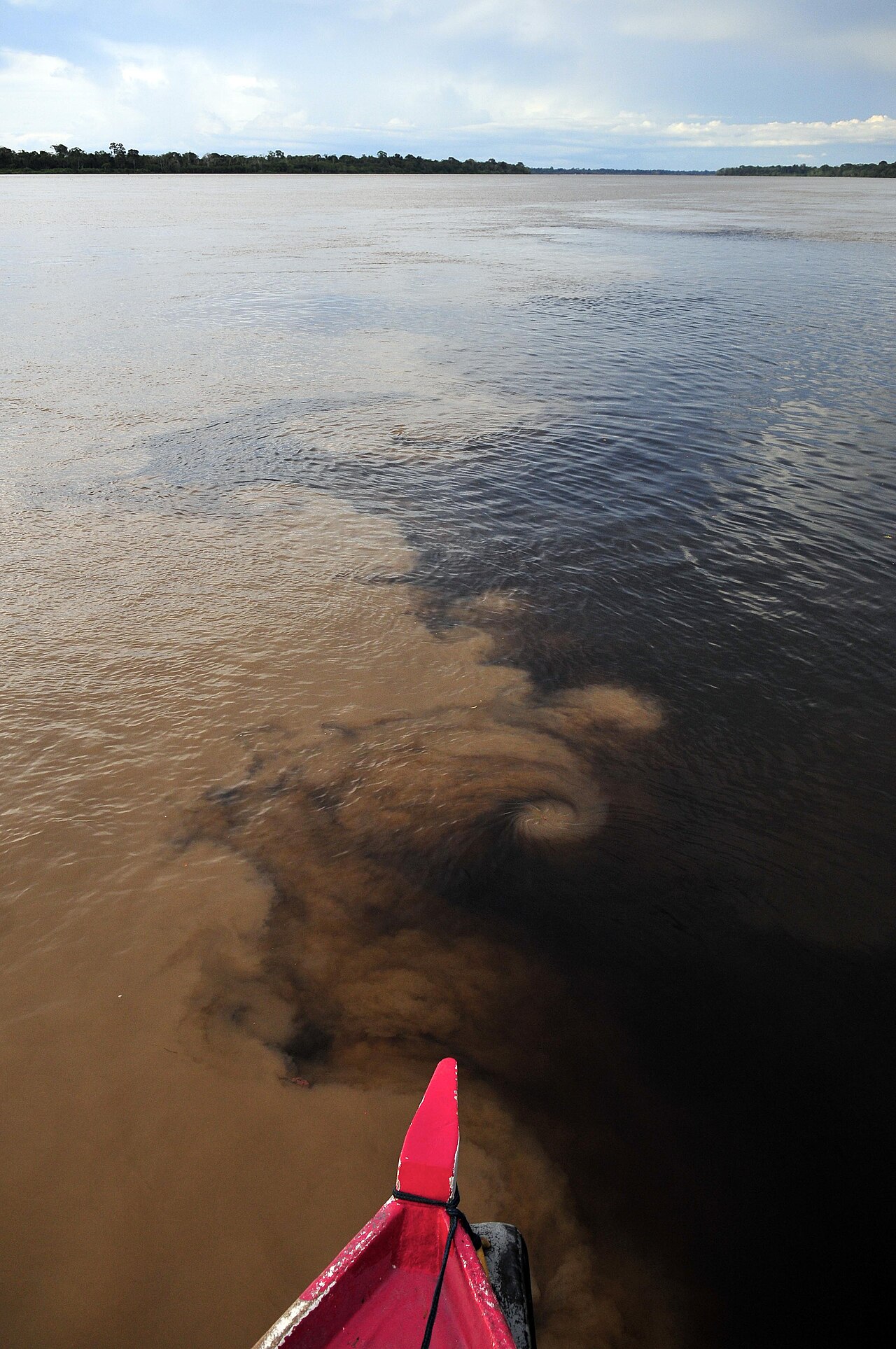
Like many Amazonian rivers whose primary headwaters originate in the Andes, the Madeira carries a heavy sediment load that gives it a distinctive turbid, whitewater character. Yet its tributaries present a striking contrast: the Aripuanã and Ji-Paraná run with clear water, while the Manicoré flows with the dark, tannin-stained waters typical of blackwater rivers. This diversity of water types supports a rich aquatic ecosystem, including the Bolivian river dolphin, a species whose taxonomic status as a subspecies has been debated among biologists. On the river's north bank, opposite the town of Novo Aripuanã, the Rio Madeira Sustainable Development Reserve—established in 2006 and covering roughly 2,800 square kilometers—protects a significant stretch of riparian habitat. At the river's mouth, the extensive marshland of Ilha Tupinambaranas, formed by the Madeira's distributaries, adds another layer of ecological complexity to this already biodiverse waterway.
Gallery
Frequently Asked Questions
What is the Madeira River?
The Madeira is a major South American waterway and the single largest tributary feeding into the Amazon. It contributes roughly 15% of the total water volume in the Amazon basin.
How is the Madeira River formed?
The river begins at the confluence of the Beni and Mamoré rivers near the Bolivia-Brazil border. From that junction it flows eastward across Brazil toward its mouth at the Amazon.
How long is the Madeira River?
The main channel measures about 1,450 kilometers (900 miles). If you trace the full drainage path through the Mamoré tributary, estimates range from roughly 3,250 to 3,380 kilometers depending on the measuring method.
Why is the Madeira River important?
Around 1,070 kilometers of its course are navigable during the rainy season, making it a vital shipping corridor for grain exports and regional trade. Its catchment area of about 850,000 square kilometers is nearly the size of France and Spain combined.
What is the indigenous name for the Madeira River?
Before European naming, the river was called Cuyari, a pre-colonial indigenous term. That name appears on an 1747 map by cartographer Emanuel Bowen, preserved in the David Rumsey Map Collection.
More in Rivers Of The World 1-20
Spotted an error? Know more?
This is a living reference — every entry is fact-audited, and reader corrections feed straight into our audit queue. Suggest an edit · See this site's audit record