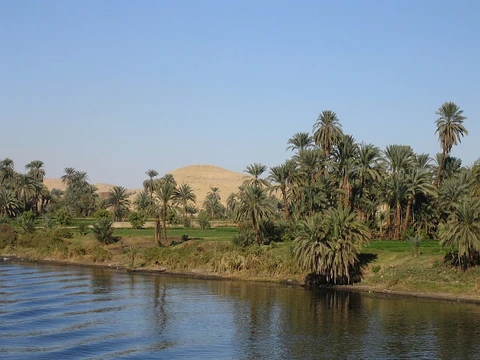
Murray River
Australia's longest river, vital for irrigation and ecology.

via Wikipedia: Murray River · see source
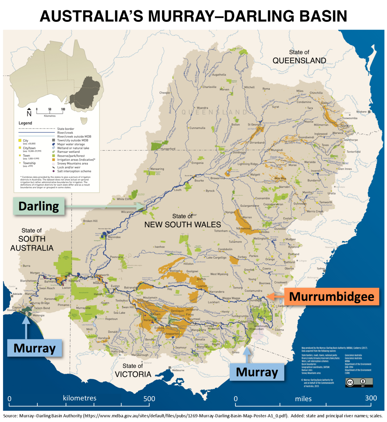
The Murray River, known as Millewa to the Ngarrindjeri people and Dhungala or Tongala to the Yorta Yorta, flows through southeastern Australia. Stretching 2,508 kilometers, it holds the title of the country’s longest river. Five of Australia’s next six longest rivers—the Murrumbidgee, Darling, Lachlan, Warrego, and Paroo—are its tributaries. Together with the Murray, their catchments make up the Murray–Darling basin, which spans roughly one-seventh of Australia’s land area. This basin is regarded as the nation’s most vital irrigated zone.
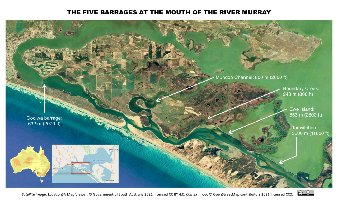
The river begins in the Australian Alps, draining the western slopes of the country’s highest peaks. From there, it meanders northwest across inland plains, forming the border between New South Wales and Victoria before entering South Australia. Near Morgan, it shifts from an east–west course to a southern one for its final 315 kilometers, reaching the eastern edge of Lake Alexandrina, a lake with fluctuating salinity. The water then passes through channels around Hindmarsh and Mundoo Islands, where it meets lagoon water from The Coorong to the southeast. Finally, it empties into Encounter Bay on the Southern Ocean through the Murray Mouth, about 10 kilometers east of Goolwa South. Although the river can discharge large volumes, especially before large-scale regulation, the waters at the mouth are almost always slow and shallow. As of 2010, the system received just 58 percent of its natural flow, though this figure varies.
The border between Victoria and New South Wales runs along the top of the river’s southern (left) bank, not the middle. This means that until the river enters South Australia, the entire water and riverbed belong to New South Wales. The combined Murray–Darling system stretches 3,750 kilometers, draining most of inland Victoria, New South Wales, and southern Queensland. Compared to rivers of similar length elsewhere, the Murray carries only a small fraction of water, with highly variable annual flows. Since official records began, it has dried up completely during three extreme droughts. More commonly, a sandbar forms at the mouth, stopping the flow.
A 1980 High Court ruling addressed the border ambiguity after a man died while fishing on the Victorian bank. Because the river’s course changes over time and banks have been modified, the boundary can be unclear. For 11 kilometers west of the 141°E line of longitude, the border between Victoria and South Australia lies in the middle of the river. This discrepancy arose from an east–west miscalculation of 3.72 kilometers during an 1840s survey, leading to a long-running dispute. West of this sector, the Murray lies entirely within South Australia.
The Murray agricultural region, centered on the river, includes nine local government areas: Albury, Balranald Shire, Berrigan Shire, Edward River Council, Federation Council, Greater Hume Shire, Murray River Council, Wentworth Shire, and Snowy Valleys Council. Major settlements along its course, from source to ocean, have populations recorded in the 2016 Australian census.
The river and its tributaries host a range of native life adapted to its fluctuations. Fish include the famous Murray cod, trout cod, golden perch, Macquarie perch, silver perch, eel-tailed catfish, Australian smelt, and western carp gudgeon. Other aquatic species include the Murray short-necked turtle, broad-clawed yabbies, and the large-clawed Macrobrachium shrimp. More widely distributed species like common long-necked turtles, common yabbies, the small clawless paratya shrimp, water rats, and platypus also live here. The endangered Murray crayfish has seen its numbers increase thanks to scientific efforts. River red gum forests and fringing corridors line the Murray.
Since European settlement, the river’s health has declined sharply, especially due to flow regulation. Extreme droughts from 2000 to 2007 stressed river red gum forests, raising concerns about their survival. Floods have also occurred, most notably in 1956, when waters inundated many lower-reach towns in South Australia for up to six months.
Between 2.5 and 0.5 million years ago, the river ended in a vast freshwater lake called Lake Bungunnia, formed by earth movements that blocked the river near Swan Reach. At its largest, the lake covered 33,000 square kilometers, extending near the Menindee Lakes to the north and Boundary Bend to the south. It drained about 600,000 years ago. Deep clays from the lake are visible in cliffs around Chowilla, South Australia. Keeping such a lake full would have required much higher rainfall; its draining likely marked the end of a wet period in the Murray–Darling Basin and the start of widespread arid conditions similar to today. A species of Neoceratodus lungfish once lived in Lake Bungunnia.
- length
- 2,508 km (1,558 mi)
- source
- Australian Alps
- mouth
- Encounter Bay, Southern Ocean
- basin_area
- about one-seventh of Australia
- flow_status
- 58% of natural flow as of 2010
- border_role
- Forms border between New South Wales and Victoria (southern bank), and between V
Verified Timeline
Lore & Background
The Murray rises in the Australian Alps, draining the western side of Australia's highest mountains, then meanders northwest across Australia's inland plains, forming the border between the states of New South Wales and Victoria as it flows into South Australia. The border lies along the top of the southern or left bank of the Murray River, meaning the entire river—including the water and the riverbed—falls entirely within New South Wales until it enters South Australia. From an east–west direction it turns south at Morgan for its final 315 km (196 mi), reaching the eastern edge of Lake Alexandrina. The water then flows through several channels around Hindmarsh Island and Mundoo Island, joined by lagoon water from The Coorong before emptying into Encounter Bay through the Murray Mouth, 10 km (6.2 mi) east of Goolwa South. As of 2010, the Murray River system received just 58 per cent of its natural flow, though this figure varies considerably. The Murray carries only a small fraction of the water of comparably sized rivers in other parts of the world, and with great annual variability of its flow. It has dried up completely during extreme droughts on three occasions since official record-keeping began. The Murray and its tributaries support native fish such as the famous Murray cod, trout cod, golden perch, Macquarie perch, silver perch, eel-tailed catfish, Australian smelt and western carp gudgeon, as well as other aquatic species such as the Murray short-necked turtle, broad-clawed yabbies, water rats and platypus. The health of the Murray has declined significantly since European settlement, particularly through regulation of its flows. Extreme droughts between 2000 and 2007 put significant stress on river red gum forests, leading to mounting concern over their long-term survival. Ancient history includes Lake Bungunnia, a vast freshwater lake that existed between 2.5 and 0.5 million years ago, covering 33,000 km² (12,741 sq mi). The draining of Lake Bungunnia occurred approximately 600,000 years ago. About 25,000 years ago, displacement occurred along the Cadell Fault, raising its eastern edge 8 to 12 m (26 to 39 ft) above the floodplain. This created a complex series of events that led to the formation of the famous Barmah river red gum forests. The Murray Mouth has been dredged since the early 2000s, with machines operating for 24 hours a day moving sand from the channel to maintain a minimal flow from the sea and into the Coorong's lagoon system.
Reader's Guide
The Murray River is central to Australia's geography, economy, and ecology. As the longest river in Australia, spanning 2,508 km (1,558 mi), it forms the backbone of the Murray–Darling basin, which covers about one-seventh of the continent and is widely considered Australia's most important irrigated region. Its waters support agriculture, settlements, and unique ecosystems, including the iconic river red gum forests and native fish like the famous Murray cod. The river's flow has been heavily regulated, with only 58% of its natural flow remaining as of 2010, leading to ecological decline and concerns over the survival of forests during extreme droughts between 2000 and 2007. The river also has a complex legal role, defining the border between New South Wales and Victoria along the top of the southern bank, a boundary that was subject to a 1980 High Court of Australia judgement regarding jurisdiction in the unlawful death of a man fishing on the Victorian side. The Murray Mouth has historically been a major impediment to commerce between roughly 1855 and 1920, and dredging has been required since the early 2000s to keep it open. The river's ancient past includes Lake Bungunnia, which covered 33,000 km² between 2.5 and 0.5 million years ago, and the Cadell Fault displacement about 25,000 years ago that shaped the current landscape and led to the formation of the Barmah river red gum forests. The Murray remains a vital resource, facing challenges of water management, drought, and environmental sustainability.
Did You Know?
- The Murray River has dried up completely during extreme droughts on three occasions since official record-keeping began.
- The border between Victoria and New South Wales lies along the top of the southern bank of the Murray River, meaning the entire river and riverbed falls within New South Wales until it enters South Australia.
- Between 2.5 and 0.5 million years ago, the Murray terminated in a vast freshwater lake called Lake Bungunnia, which covered 33,000 km².
- About 25,000 years ago, displacement along the Cadell Fault raised its eastern edge 8 to 12 m above the floodplain, leading to the formation of the Barmah river red gum forests.
- Since the early 2000s, dredging machines have operated at the Murray Mouth for 24 hours a day to prevent the mouth from silting up and closing.
Gallery
Frequently Asked Questions
What is the Murray River and where is it located?
The Murray River is the longest river in Australia, winding through the southeastern part of the continent. It rises in the Australian Alps and ultimately empties into Encounter Bay on the Southern Ocean.
How long is the Murray River?
It stretches 2,508 km (1,558 mi), making it the longest single watercourse in the country. Its tributary system also claims five of the next six longest rivers in Australia.
Why is the Murray River considered so important?
Together with its tributaries it forms the Murray–Darling basin, which covers roughly one-seventh of Australia's total land area and is widely regarded as the nation's most critical irrigated farming region. The river also sustains a vast network of wetlands, fish populations, and other native wildlife.
Which states does the Murray River border?
The river acts as a natural boundary between New South Wales and Victoria along its southern bank. For an 11-kilometre stretch it additionally divides Victoria from South Australia, with the border running down the middle of the channel.
What is the current flow status of the Murray River?
As of 2010, the river was carrying only about 58 percent of its natural flow, reflecting the heavy water extraction demands of the surrounding agricultural and urban communities.
More in Rivers Of The World 1-20
Spotted an error? Know more?
This is a living reference — every entry is fact-audited, and reader corrections feed straight into our audit queue. Suggest an edit · See this site's audit record