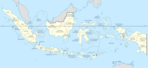
Riau Islands
Indonesian province of 2,408 islands, key maritime trade hub.

The Riau Islands, a province in western Indonesia, was carved out of Riau Province in 2002, making it the country’s third-youngest province. Its capital is Tanjung Pinang, while Batam serves as the largest city. The province spans 2,408 islands—1,798 of which are named—scattered between Sumatra, the Malay Peninsula, and Borneo. These islands sit along the Malacca Strait and the Natuna Sea, some of the world’s busiest shipping lanes, and share maritime borders with Singapore, Malaysia, Brunei, Vietnam, Cambodia, and several Indonesian provinces, including Riau, Jambi, Bangka Belitung, and West Kalimantan. The region holds significant mineral, energy, and marine resources.
For centuries, the Riau Islands have been central to Nusantara’s maritime history. From the 7th to the 13th centuries, the Srivijaya Empire, a powerful maritime kingdom, influenced the area, as evidenced by the Pasir Panjang Inscription in Karimun Regency, which features Buddha’s footprints and points to early Buddhist practices. After Srivijaya’s decline, the Bentan Kingdom emerged around 1100 AD, with Raja Iskandar Syah as a notable ruler. Later, the islands became part of the Johor Sultanate. Following the 1824 Anglo-Dutch Treaty, the region was split: the Riau-Lingga Sultanate fell under Dutch control as a protectorate from 1824 to 1911, then was directly ruled by the Dutch East Indies. Japanese occupation from 1942 to 1945 and the Indonesian National Revolution (1945–1949) led to the islands joining Indonesia. They separated from Riau Province in September 2002.
The name “Riau” has several proposed origins. One theory traces it to the Portuguese word *rio* (river), linked to Portuguese pursuits after the fall of the Malacca Sultanate in the early 16th century. Another suggests it comes from *riahi* (sea water), allegedly from Sinbad the Sailor in *One Thousand and One Nights*. A third version derives it from the Malay word *riuh* (crowded, frenzied working people), reflecting the character of Malay communities in Bintan. This name gained prominence after Raja Kecil moved the Malay kingdom’s center from Johor to Ulu Riau in 1719, becoming part of the Riau-Lingga-Johor-Pahang sultanates. The 1824 treaty split these sultanates, with Johor-Pahang under British influence and Riau-Lingga under Dutch.
The Riau Islands have long been home to Malay and Orang Laut (sea nomad) communities, with later migrants from southern China and Indochina. Today, people from across Asia have settled there. The archipelago lies on the ancient China–India maritime trade route. Chinese records note that Bintan and Temasek (old Singapore) were inhabited by Malay corsairs, who used up to 300 ships to attack Chinese vessels returning from the Indian Ocean, forcing them into pirate harbors. Large quantities of Chinese ceramics from the early Song dynasty (960–1127) have been found on Bintan. The 13th-century Arab explorer Ibn Battuta described armed black pirates on small islands, and 12th-century Chinese ship logs confirm such raids. Despite centuries of piracy, the region has transformed.
Since the 1970s, the Riau Islands have industrialized rapidly, thanks to a free trade zone within the Indonesia–Malaysia–Singapore Growth Triangle. As of 2011, the province had the fourth-highest GDP per capita in Indonesia, after East Kalimantan, Jakarta, and Riau. Its Human Development Index in 2018 was 0.748, also fourth-highest, behind Jakarta, Yogyakarta, and East Kalimantan. The population is highly diverse, including Malays, Chinese, Javanese, Minangkabau, and others, with economic growth drawing immigrants from across Indonesia. Batam hosts many expatriates, about 80% from other Asian countries, with Westerners mostly from the UK, Europe, Australia, and the US. The province ranks second in Indonesia for foreign tourist arrivals, after Bali.
- Capital
- Tanjung Pinang
- Largest City
- Batam
- Established
- 2002
- Total Islands
- 2,408 (1,798 named)
- GDP per capita (2011)
- Rp 72,571,750 (US$8,300.82)
- Human Development Index (2018)
- 0.748
- Foreign Tourist Arrivals
- Second largest in Indonesia after Bali
Verified Timeline
Quick Facts
- Settlement Type
- Province
- Shield Link
- Armorial of Indonesia#Provincial
- Shield Size
- 80
- Subdivision Type
- Country
- Subdivision Name
- Indonesia
- Subdivision Type1
- Region
- Subdivision Name1
- Sumatra (Western Indonesia)
- Established Title
- Established
- Established Date
- 24 September 2002
- Seat Type
- Capital
- Seat
- Tanjungpinang
- Seat1 Type
- Largest city
Facts from the source article.
Lore & Background
The Riau Islands have for centuries been the home of Malay and Orang Laut people. Chinese maritime records indicate that Bintan and Temasek, the old name of Singapore, were inhabited by Malay corsairs. Large quantities of Chinese ceramics have been recovered on Bintan, some dating back to the early Song dynasty (960–1127). Arab explorer Ibnu Battuta wrote about Riau in the 13th century: 'Here there are little islands, from which armed black pirates with poised arrows emerged, possessing armed warships; they plunder people but do not enslave them.' Between the 7th and 13th centuries, the area was influenced by the Srivijaya Empire, as seen from the discovery of the Pasir Panjang Inscription in Karimun Regency, which shows Buddha's footprints, indicating early settlement and the spread of Buddhism. After Srivijaya's decline, the Riau Islands became part of the Bentan Kingdom around 1100 AD, with Raja Iskandar Syah as one of its most notable rulers. Later, the islands were part of the Johor Sultanate, which was partitioned after the Anglo-Dutch Treaty of 1824, placing the archipelago under Dutch influence. A Dutch protectorate, the Riau-Lingga Sultanate, was established between 1824 and 1911 before direct Dutch rule. The archipelago became part of Indonesia following the Japanese occupation (1942–1945) and the Indonesian National Revolution (1945–1949).
Reader's Guide
The Riau Islands separated from the province of Riau in September 2002, becoming Indonesia's third-youngest province. A free trade zone of the Indonesia–Malaysia–Singapore Growth Triangle, the Riau Islands has experienced rapid industrialization since the 1970s. It is one of the country's most prosperous provinces, having a GDP per capita of Rp 72,571,750 (US$8,300.82) as of 2011, the fourth highest among all provinces in Indonesia. As of 2018, the Riau Islands has a Human Development Index of 0.748, also the fourth highest. The population is highly diverse, including Malays, Chinese, Javanese, Minangkabau, and others. The area around Batam is home to many expatriates, with approximately 80% from other Asian countries, and most westerners from the United Kingdom, rest of Europe, Australia, and the United States. The province has the second largest number of foreign tourist arrivals in Indonesia, after Bali. The etymology of 'Riau' has several possible origins: from the Portuguese word 'rio' (river), from the word 'riahi' (sea water) allegedly derived from Sinbad al-Bahar, or from the Malay word 'riuh' (crowded, frenzied working people). The name became famous after Raja Kecil moved the Malay kingdom center from Johor to Ulu Riau in 1719.
Did You Know?
- The Riau Islands comprises 2,408 islands, of which 1,798 have names.
- The Pasir Panjang Inscription in Karimun Regency shows Buddha's footprints, indicating the spread of Buddhism long before Islam arrived.
- Arab explorer Ibnu Battuta wrote about Riau in the 13th century, describing armed black pirates.
- The Riau Islands has the second largest number of foreign tourist arrivals in Indonesia, after Bali.
- The name 'Riau' may come from the Portuguese word 'rio' (river), the word 'riahi' (sea water), or the Malay word 'riuh' (crowded, frenzied working people).
Frequently Asked Questions
Who is Riau Islands?
Riau Islands is an Indonesian province made up of 2,408 scattered islands sitting between Sumatra, the Malay Peninsula, and Borneo, with Tanjung Pinang as its capital and Batam as its biggest city. It was officially carved out of the larger Riau Province back in 2002.
What are Riau Islands's powers/role?
Its core 'ability' is commanding a vital stretch of the Malacca Strait and the Natuna Sea, which puts it on one of the most heavily trafficked shipping corridors on Earth. In practice this makes the province a key maritime trade hub for the whole Nusantara region.
How does Riau Islands's story end?
Because it is a living, ongoing province there is no final chapter, but its long-arc narrative is defined by sustained growth: a 2011 GDP per capita of roughly Rp 72.6 million and a 2018 HDI of 0.748 both point to a region steadily climbing the development ladder.
Why is Riau Islands important?
It inherits the maritime legacy of both the Srivijaya Empire and the later Johor Sultanate, and its position wedged between three major landmasses makes it a natural chokepoint for global trade. Few other Indonesian provinces sit as squarely on the world's busiest sea lanes.
When was Riau Islands established and how did it come to be?
The province officially entered the canon in 2002, split off from Riau Province to get its own administrative identity. Of its 2,408 total islands, 1,798 have been formally named, giving the province a distinctly archipelagic character.
More in Provinces Of Indonesia 1-24
Related in Provinces Of Indonesia
Links follow this subject's own source article.
Spotted an error? Know more?
This is a living reference — every entry is fact-audited, and reader corrections feed straight into our audit queue. Suggest an edit · See this site's audit record