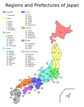
Gifu Prefecture
Historic crossroads of Japan, home to Sengoku-era warlords.

via Wikipedia: Gifu Prefecture · see source
Gifu Prefecture, located in the Chūbu region of Honshu, is one of Japan’s only eight landlocked prefectures, covering 10,621 square kilometers with a population of 2,040,000. Its capital and largest city is Gifu, with other major cities including Ōgaki, Kakamigahara, and Tajimi. The prefecture’s geography is divided into two distinct regions: the mountainous northern Hida area, which includes parts of the Japanese Alps and the Hida Mountains (known as the "Northern Alps"), and the southern Mino region, dominated by the fertile Nōbi Plain formed by the alluvial plains of the Kiso, Nagara, and Ibi rivers. This southern area holds most of the population. The climate transitions from humid subtropical in the south to humid continental in the north; the city of Tajimi, surrounded by low mountains, often records Japan’s highest temperatures, including a record 40.9°C in August 2007. Historically, the land became part of the Yamato Court around the mid-fourth century and was the site of the Jinshin War in 672. The prefecture comprises the old provinces of Hida and Mino, plus smaller parts of Echizen and Shinano. Its name was chosen by Oda Nobunaga in 1567, using characters from Chinese legend to symbolize unification and wisdom. Nobunaga and Saitō Dōsan both resided here, leading to the medieval saying "control Gifu and you control Japan." Gifu was also the center of Japan’s swordmaking industry, with Seki producing the finest swords. Modern strengths include fashion in Gifu City and aerospace engineering in Kakamigahara. The 1891 Mino–Owari earthquake, the second largest in Japan’s history, had its epicenter near present-day Motosu, leaving a visible fault scarp. The prefecture is home to Gifu Castle, the 1,300-year-old cormorant fishing tradition on the Nagara River, and the Battle of Sekigahara site. It also hosts the Hakusan and Chūbu-Sangaku National Parks, among other protected areas.
- Population
- 2,040,000 (as of April 1, 2025)
- Area
- 10,621 square kilometres (4,101 sq mi)
- Capital
- Gifu
- Region
- Chūbu region, Honshu
- Known for
- Historic crossroads, cormorant fishing, swordsmithing, Washi paper
Quick Facts
- Native Name
- ja · 岐阜県
- Settlement Type
- Prefecture
- Translit Lang1
- Japanese
- Translit Lang1 Type1
- Rōmaji
- Translit Lang1 Info1
- ja-Latn · Gifu-ken
- Flag Size
- 100px
- Blank Emblem Size
- 80px
- Blank Emblem Type
- Symbol
- Subdivision Type
- Country
- Subdivision Name
- Japan
- Subdivision Type1
- Region
- Subdivision Name1
- Chūbu (Tōkai)
Facts from the source article.
Lore & Background
The land area that makes up modern-day Gifu became part of the Yamato Court around the middle of the fourth century. Because it is in the middle of Honshu, it has been the site of many decisive battles, the oldest major one being the Jinshin War in 672, which led to the establishment of Emperor Tenmu as the 40th emperor of Japan. The area consists of the old provinces of Hida and Mino, as well as smaller parts of Echizen and Shinano. The name of the prefecture derives from its capital city, Gifu, which was named by Oda Nobunaga during his campaign to unify all of Japan in 1567. The first character comes from Qishan, a legendary mountain from which most of China was unified, and the second from Qufu, the birthplace of Confucius. Nobunaga chose those characters because he wanted to unify all of Japan and be viewed as a great mind. Historically, the prefecture served as the center of swordmaking for all of Japan, with Seki known for making the best swords. The Mino region has long been known for its high-quality paper called Mino washi, which is stronger and thinner than most other papers in Japan and was used by the Japanese military during World War II. Other traditional goods include Gifu lanterns, Gifu umbrellas, mino-yaki pottery in Tajimi, Toki, and Mizunami, cutlery in Seki, and lacquerware in Takayama. The prefecture is also home to the 1,300-year-old tradition of cormorant fishing on the Nagara River.
Reader's Guide
Gifu Prefecture's significance lies in its central location and historical role as a crossroads of Japan, influencing military and political unification during the Sengoku period. The phrase 'control Gifu and you control Japan' reflects its strategic importance. Its legacy includes traditional industries such as swordsmithing, paper-making, and cormorant fishing, which continue to define its cultural identity. Modern industries like aerospace engineering in Kakamigahara and information technology in Ōgaki and Kakamigahara have diversified its economy. The prefecture also contains the site of the Battle of Sekigahara and the UNESCO World Heritage Site of Shirakawa's historic villages. Its varied geography, from the mountainous Hida region to the fertile Nōbi Plain, supports both agriculture and tourism, including hot springs in Gero and the preserved town of Takayama, often called Little Kyoto. The Kamioka area of Hida is home to the Kamioka Observatory underground laboratory, 1,000 m underground, housing the Super-Kamiokande experiment and the KamLAND experiment.
Did You Know?
- On August 16, 2007, Tajimi set the record for the hottest day in Japan's history at 40.9 °C (105.6 °F).
- The center of Japanese population is located in Seki City, Gifu Prefecture, based on the 2005 census.
- The Mino–Owari earthquake on October 28, 1891, was the second largest earthquake to ever hit Japan, estimated at 8.0 surface-wave magnitude.
- Shōkawa-chō, part of Takayama, is called the coldest inhabited place on Honshū.
- The Super-Kamiokande experiment in Hida uses a tank 41.4 m tall and 39.3 m in diameter holding 50,000 tons of ultra-pure water.
More in Prefectures Of Japan 1-24
Related in Prefectures Of Japan
Links follow this subject's own source article.
Spotted an error? Know more?
This is a living reference — every entry is fact-audited, and reader corrections feed straight into our audit queue. Suggest an edit · See this site's audit record