Fukushima Prefecture

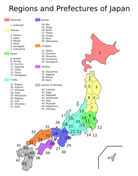
Fukushima Prefecture is a prefecture of Japan located in the Tōhoku region of Honshu. It is the third-largest prefecture in Japan by area and is divided by mountain ranges into three regions: Aizu, Nakadōri, and Hamadōri. The prefecture borders Miyagi and Yamagata prefectures to the north, Niigata to the west, and Gunma, Tochigi, and Ibaraki to the south. Its capital is Fukushima City, while Iwaki is the largest city, followed closely by Kōriyama; other major cities include Aizuwakamatsu and Sukagawa. The prefecture is situated on Japan’s eastern Pacific coast at the southernmost part of Tōhoku and is home to Lake Inawashiro, the fourth-largest lake in Japan. Historically, the area was part of Mutsu Province until the Meiji Restoration. Ancient barriers, the Shirakawa and Nakoso, were built around the 5th century to defend against northern groups. The Shiramizu Amidadō, a chapel built in 1160 within the temple Ganjō-ji in Iwaki, is a National Treasure. In 1882, the Fukushima Incident, a political upheaval, occurred after Mishima Michitsune became governor. On March 11, 2011, a magnitude 9.0 earthquake struck off Miyagi’s coast, causing shaking up to 6-upper in parts of Hamadōri and 6-lower in Fukushima City. The ensuing tsunami devastated the eastern coast, and the earthquake triggered the failure of Fujinuma Dam and landslides. Over two years, 1,817 residents were confirmed dead or missing. The disaster also led to meltdowns and explosions at three reactors of the Fukushima Daiichi Nuclear Power Plant in Ōkuma, releasing large amounts of radioactive material. Radiation near the plant peaked at 400 mSv/h, and the event was later classified as a level 7 incident, the highest since Chernobyl. Months afterward, areas near the 20-kilometer safe zone began allowing the return of nearly 47,000 evacuated residents. Geographically, the coastal Hamadōri region is the flattest and most temperate, Nakadōri is the agricultural heartland, and the mountainous Aizu region features scenic lakes and snowy winters. Mount Bandai is the highest peak, and Mount Azuma-kofuji is an active stratovolcano with many hot springs. As of 2012, 13% of the prefecture’s land was designated as natural parks, including Bandai-Asahi, Nikkō, and Oze National Parks.
- capital
- Fukushima
- largest_city
- Iwaki
- region
- Tōhoku, Honshu, Japan
Lore & Background
Fukushima Prefecture is located on Japan's eastern Pacific coast at the southernmost part of the Tōhoku region. Historically, until the Meiji Restoration, the area was part of Mutsu Province. The Shirakawa Barrier and Nakoso Barrier were built around the 5th century. The earthquake caused damage including the failure of Fujinuma Dam and landslides. The tsunami led to explosions, partial meltdown, and fires at the Fukushima Daiichi Nuclear Power Plant. The prefecture is home to Lake Inawashiro, the fourth-largest lake in Japan. The coastal Hamadōri region is flat and temperate, Nakadōri is agricultural, and Aizu is mountainous with snowy winters. The prefecture produces peaches, cucumbers, rice, sake, and lacquerware. Cultural items include Akabeko cows, Okiagari-koboshi dolls, and Kokeshi dolls, which are credited as originating in Fukushima.
Reader's Guide
The event led to widespread evacuation, long-term radiation concerns, and a global reassessment of nuclear safety. The prefecture's geography, divided into three distinct regions, influences its economy: coastal fishing and nuclear power, and upland agriculture. Fukushima produces a notable share of Japan's peaches and cucumbers, and its sake is served to visiting royalty. Culturally, the prefecture is the birthplace of Kokeshi dolls and hosts festivals such as the Sōma Nomaoi, featuring samurai-attired horse riders. The Ōyasuba Kofun, a keyhole-shaped burial mound, is the largest in the Tōhoku region and a National Historic Site. The prefecture's designation as the third-largest in Japan, its natural parks, and its location on the Pacific Ring of Fire contribute to its environmental and tectonic significance.
Did You Know?
- Fukushima Prefecture is the third-largest prefecture in Japan by area, after Hokkaido and Iwate Prefecture.
- The Ōyasuba Kofun is the largest keyhole-shaped kofun in the Tōhoku region and was designated a National Historic Site in 2000.
- Kokeshi dolls, a popular traditional craft, are credited as originating in Fukushima Prefecture.
More in Prefectures Of Japan 1-24
Spotted an error? Know more?
This is a living reference — every entry is fact-audited, and reader corrections feed straight into our audit queue. Suggest an edit · See this site's audit record