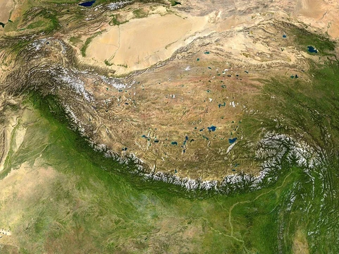
Tibetan Plateau
Largest and highest plateau in the world, sometimes called the 'Roof of the World'.

The Tibetan Plateau, also known as the Qinghai–Tibet or Qingzang Plateau, is a vast elevated region at the intersection of Central, South, and East Asia. It is the world’s largest and highest plateau above sea level, stretching roughly north to south and east to west, with an area of approximately 2,500,000 square kilometers and an average elevation exceeding 5,000 meters. Surrounded by imposing mountain ranges that include the world’s two highest summits, Mount Everest and K2, it is often called the "Roof of the World." The plateau is bordered to the south by the inner Himalayan range, to the north by the Kunlun Mountains (which separate it from the Tarim Basin), and to the northeast by the Qilian Mountains. To the west, the rugged Karakoram range curves around its edge. The plateau contains the headwaters of most major streams in surrounding regions, including the three longest rivers in Asia: the Yellow, Yangtze, and Mekong. Its tens of thousands of glaciers and other features serve as a natural "water tower," storing water and regulating river flow, earning it the nickname "Third Pole" because its ice fields hold the largest reserve of fresh water outside the polar regions. Geologically, the plateau’s formation is tied to the collision of the Indo-Australian and Eurasian plates, which began around 55–50 million years ago. This collision closed the Tethys Ocean, crumpling its light sediments into mountain ranges. The plateau’s mean elevation has varied since its initial uplift; isotopic records indicate it was around 3,000 meters above sea level near the Oligocene–Miocene boundary, then fell by 900 meters between 25.5 and 21.6 million years ago before rising again by 500 to 1,000 meters between 21.6 and 20.4 million years ago. Today, the plateau is a high-altitude arid steppe interspersed with mountain ranges and large brackish lakes. Its southern and eastern edges have grasslands supporting nomadic herdsmen, though frost occurs for six months yearly. To the north and northwest, the plateau becomes higher, colder, and drier, with annual precipitation comparable to a polar desert and extensive permafrost. The remote Changtang region in the northwest averages over 5,000 meters in altitude, with winter temperatures frequently below -30°C, making it unsuitable for permanent settlement except for a few nomadic herders in its southern part.
- Area
- 2,500,000 square kilometers (970,000 sq mi)
- Average Elevation
- about 5,000 m (16,000 ft) above sea level
Lore & Background
The Tibetan Plateau is enclosed by fold mountains, making it an intermontane plateau. It lies between the Himalayas and Kunlun Mountains. The plateau's immense size and height have a dramatic effect on global climate: it is sufficiently high to reverse the Hadley cell convection cycles and to drive the monsoons of India towards the south. Its formation is an ongoing process, driven by the collisions of the Indo-Australian and Eurasian tectonic plates. The Deosai Plains in Pakistan, situated at an average elevation of 4,114 meters (13,497 ft) above sea level, are considered to be the second highest plateaus in the world.
Reader's Guide
When visiting the Tibetan Plateau, you are standing on the world's largest and highest plateau, covering approximately 2,500,000 km² (970,000 sq mi) at about 5,000 m (16,000 ft) above sea level. Its formation is a direct result of the ongoing collisions of the Indo-Australian and Eurasian tectonic plates. This immense height has a profound effect on the climate, as the plateau is sufficiently high to reverse the Hadley cell convection cycles and to drive the monsoons of India towards the south. For comparison, the Deosai Plains in Pakistan, at an average elevation of 4,114 meters (13,497 ft), are considered the second highest plateaus in the world.
Did You Know?
- The Tibetan Plateau is sometimes metaphorically described as the 'Roof of the World'.
- It is still being formed by the collisions of the Indo-Australian and Eurasian tectonic plates.
- The plateau covers approximately 2,500,000 km² (970,000 sq mi).
- It is sufficiently high to reverse the Hadley cell convection cycles.
- The plateau's height drives the monsoons of India towards the south.
Frequently Asked Questions
Who is Tibetan Plateau?
Tibetan Plateau is the largest and highest plateau on Earth, often nicknamed the 'Roof of the World.' It stretches across roughly 2,500,000 square kilometers at an average elevation of about 5,000 meters above sea level.
What are Tibetan Plateau's powers or role?
Its extreme altitude is strong enough to flip Hadley cell convection cycles and push the Indian monsoon winds southward. It also keeps growing taller as the Indo-Australian plate grinds into the Eurasian plate.
How does Tibetan Plateau's story end?
It has no fixed ending—geologists describe the plateau as still actively forming through ongoing tectonic collision. Its 'arc' is literally still being written in real time.
Why is Tibetan Plateau important?
As the planet's highest and largest elevated landmass, it acts as a climatic engine that reshapes atmospheric circulation and drives monsoon patterns across South Asia. Its sheer scale and height make it a defining feature of global geography.
What are Tibetan Plateau's key stats?
It covers approximately 2,500,000 km² (970,000 sq mi) and sits at an average elevation of roughly 5,000 m (16,000 ft) above sea level, holding both the 'largest' and 'highest' plateau titles simultaneously.
More in Plateaus And Plains 1-24
Related in Plateaus And Plains
Links follow this subject's own source article.
Spotted an error? Know more?
This is a living reference — every entry is fact-audited, and reader corrections feed straight into our audit queue. Suggest an edit · See this site's audit record