Atlantic Plain
Flattest US physiographic division spanning Atlantic and Gulf coasts.

via Wikipedia: Plain · see source
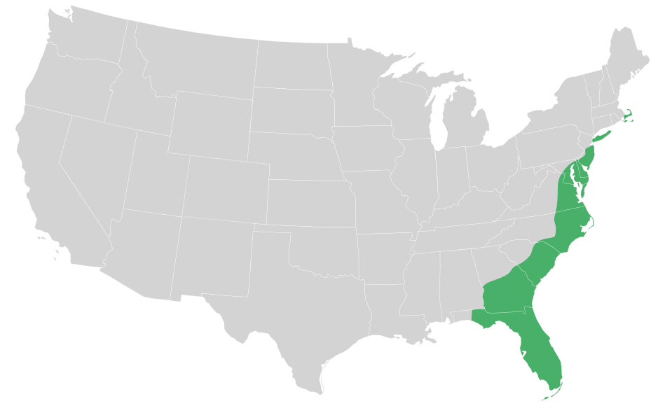
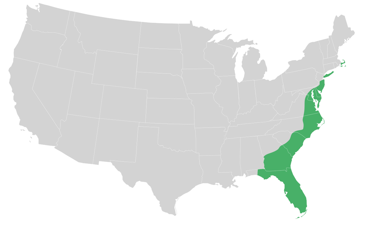
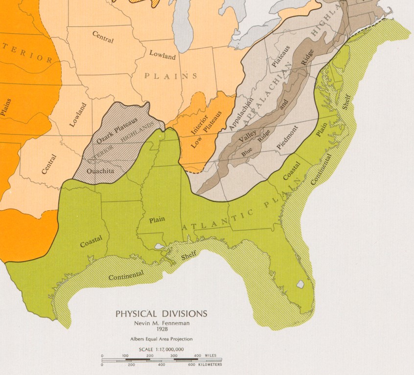
The Atlantic Plain is one of eight distinct physiographic divisions of the contiguous United States, as classified by the USGS. This division encompasses two provinces: the Coastal Plain and the Continental Shelf, differentiated simply by whether the landmass lies above or below sea level. The Atlantic Plain is the flattest of all U.S. physiographic divisions, stretching over 2,000 miles in length from Cape Cod, Massachusetts, to the Mexican border, and extending southward to the Yucatán Peninsula. The lands adjacent to the Atlantic coastline feature sandy beaches, marshlands, bays, and barrier islands. The central and southern Atlantic Coast is characterized by barrier and drowned valley coasts, with nearly continuous barriers interrupted by inlets, large embayments, and extensive wetlands and marshes. The plain slopes gently seaward from inland highlands in a series of terraces, a slope that continues far into the Atlantic and Gulf of Mexico to form the continental shelf. The relief at the land-sea interface is so low that the boundary is often blurry, especially along the Louisiana bayous and the Florida Everglades. The Coastal Plain province includes all or portions of 20 states, from Massachusetts to Texas, and consists of six physiographic sections: Embayed, Sea Island, Floridian, East Gulf Coastal Plain, Mississippi Alluvial Plain, and West Gulf Coastal Plain. Its rocks are largely layers of sand and clay not yet hardened into sandstone and shale. Elevation is less than 90 meters above sea level, extending 50 to 100 kilometers inland. The plain is normally wet, with many rivers, marsh, and swampland, composed primarily of sedimentary rock and unlithified sediments, and is primarily used for agriculture. Geologically, it consists of gently dipping, undeformed Mesozoic and Cenozoic sediments that thicken toward the sea, reaching a maximum thickness of about 3 kilometers near Cape Hatteras, North Carolina. The Atlantic Coastal Plain is now identified as a global biodiversity hotspot, with over 1,500 endemic plant species and roughly 70 percent habitat loss, particularly in longleaf pine savannas and woodlands.
- Division
- Atlantic Plain
- Physiographic provinces
- Coastal Plain, Continental Shelf
- Elevation
- Less than 90 meters above sea level
- Geology
- Gently dipping undeformed Mesozoic and Cenozoic sediments, thickening seaward to
Lore & Background
The Atlantic Plain is the flattest of the eight major physiographic divisions of the contiguous United States. Its appearance along the Atlantic coastline is defined by sandy beaches, marshlands, bays, and barrier islands. The central and southern portions of this coast feature barrier islands and drowned valley coasts, with nearly continuous barriers broken by inlets, large embayments, and extensive wetlands. The plain slopes gently seaward from inland highlands in a series of terraces, and this low gradient continues far into the Atlantic and Gulf of Mexico as the continental shelf. The relief at the shoreline is so minimal that the boundary between land and sea is often indistinct, especially in the Louisiana bayous and the Florida Everglades. The division comprises two provinces: the Coastal Plain, which lies above sea level, and the Continental Shelf, which lies below. The continental shelf is broad and flat, reaching a depth of 100 meters, and varies in width from less than one kilometer off Florida to over 420 kilometers off Maine. The Coastal Plain province includes portions of twenty states, stretching from Cape Cod, Massachusetts, to South Padre Island, Texas. Its elevation is less than 90 meters above sea level and extends 50 to 100 kilometers inland. The rocks here are mostly layers of sand and clay not yet hardened into sandstone and shale. The plain is normally wet, with many rivers, marsh, and swampland, and is composed primarily of sedimentary rock and unlithified sediments, used largely for agriculture. The Atlantic Plain is generally underlain by gently dipping, undeformed Mesozoic and Cenozoic sediments that thicken toward the sea, reaching a maximum thickness of about 3 kilometers near Cape Hatteras, North Carolina.
Reader's Guide
The Atlantic Plain is significant as the flattest and one of the most ecologically diverse physiographic divisions of the contiguous United States. The plain's longleaf pine savannas and woodlands are fire-dependent ecosystems that support endemic flora and fauna, including the red-cockaded woodpecker, gopher tortoise, and American alligator. Its geology—gently dipping Mesozoic and Cenozoic sediments—records a long history of terrestrial refugia dating to the late Cretaceous. The plain's low relief and extensive wetlands, marshes, and barrier islands shape its distinctive coastal environment, which is primarily used for agriculture. The region's ecological importance and high endemism underscore its value for conservation and study.
Did You Know?
- The Atlantic Plain is the flattest of the eight physiographic divisions of the contiguous United States.
- The plain comprises two provinces: the Coastal Plain (above sea level) and the Continental Shelf (below sea level).
- Its geology consists of gently dipping undeformed Mesozoic and Cenozoic sediments, thickening seaward to about 3 km near Cape Hatteras.
Definition and Global Prevalence
A plain, often referred to as flatland, is a broad, level stretch of terrain where elevation shifts are minimal and gradual rather than abrupt or steep. These landforms appear in remarkably diverse settings: nestled within valleys where they are bounded on two sides, enclosed by rings of hills or mountain ranges, stretching along coastlines where they ascend from sea level toward higher features, or existing as elevated plateaus and uplands. What makes plains truly remarkable is their sheer ubiquity. They exist on every continent and collectively account for more than one-third of Earth's total land surface. Where multiple plains occur within a single geological region, they can be linked by passes or gaps. This widespread presence underscores plains as one of the fundamental building blocks of the planet's topography, shaping landscapes from coastal edges to the bases of towering mountain ranges and defining the character of entire regions.
Formation Mechanisms
Plains come into being through several distinct geological processes. Depositional plains are built up by the accumulation of material: rivers lay down sediment over long periods to create alluvial and flood plains; glaciers deposit stratified gravel and sand in outwash plains, also called sandar, or leave unsorted till in till plains; former lake beds become lacustrine plains; and sheets of flowing lava produce lava plains. Erosional plains, by contrast, are the product of wearing down—running water, wind, and ice gradually smooth rugged surfaces into what geologists term peneplains, while wind-driven leveling creates pediplains. Structural plains represent yet another origin: they are relatively undisturbed horizontal surfaces, structurally depressed regions that form some of the most extensive natural lowlands on Earth. The term planitia is even applied to analogous flat expanses on other worlds, such as Hellas Planitia on Mars or Sedna Planitia on Venus, showing that this landform is not unique to our planet.
Biomes and Agricultural Value
The flat terrain of plains supports an impressive range of biomes, from temperate and subtropical grasslands to semi-arid steppes, tropical savannahs, polar tundra, and in certain cases even deserts. This ecological diversity reflects the wide climatic zones in which plains occur across the globe. Beyond their biological richness, plains hold enormous practical importance for human civilization, particularly in agriculture. Where soils have been laid down as sediment, they tend to be deep and fertile, providing an ideal medium for crop cultivation. The level topography also makes it straightforward to deploy mechanized farming equipment across vast stretches of land. In regions where plains support extensive grasslands, the landscape naturally lends itself to livestock grazing. These combined qualities—rich soils, workable terrain, and productive pastures—explain why plains have been among the most heavily cultivated and settled areas on the planet throughout human history.
Global Distribution and Notable Examples
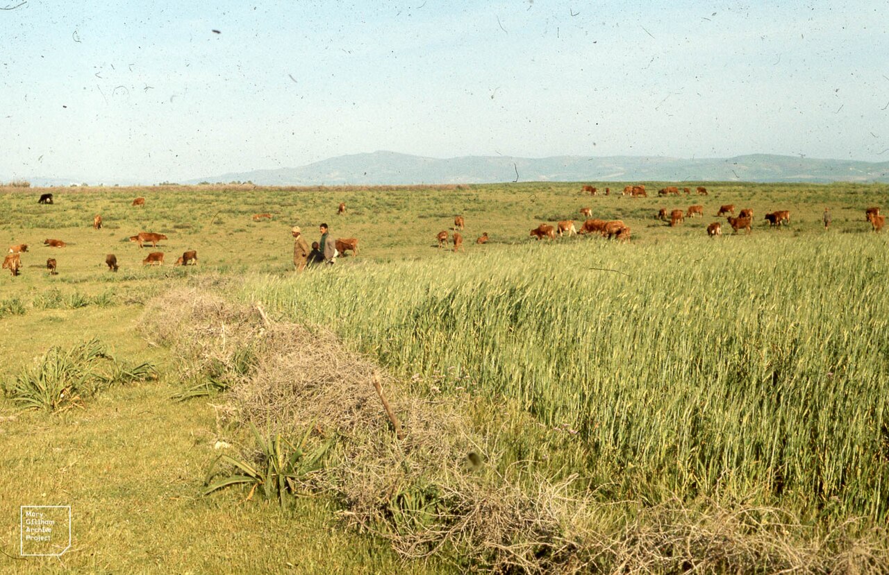
Plains span every inhabited continent, and their notable examples illustrate the geographic breadth of this landform. In the Americas, the Atlantic coastal plain stretches along the eastern United States, the Great Plains dominate the interior of Canada and the U.S., and the Pampas cover parts of Argentina, Uruguay, and Brazil. South America also offers the Altiplano, the Llanos, and the Gran Chaco. Across Asia, the Indo-Gangetic Plains span Bangladesh, India, Nepal, and Pakistan; the North China Plain and the Kantō and Nōbi Plains in Japan are major examples; and the West Siberian Plain in Russia is among the largest. In Europe, the North German Plain, the Pannonian Basin, and the Danubian Plain represent significant flatland regions. Even in smaller settings, plains appear—such as the Chianan Plain in Taiwan, the Osaka Plain in Japan, or the Israeli coastal plain—demonstrating that this landform is not limited to vast continental interiors but occurs at every scale.
Gallery

Frequently Asked Questions
Who is Atlantic Plain?
Atlantic Plain is entry 1-24 in the Plateaus And Plains series, representing one of the USGS's eight physiographic divisions of the contiguous United States. It holds the distinction of being the flattest division in the entire lineup, stretching along both the Atlantic and Gulf coastlines.
What are Atlantic Plain's powers/role?
It spans two provinces (Coastal Plain and Continental Shelf) and six sections, showcasing sandy beaches, marshlands, bays, and barrier islands. Its underlying geology is made of gently tilting Mesozoic and Cenozoic sediment layers that grow thicker toward the ocean.
How does Atlantic Plain's story end?
The division's terrain never rises above 90 meters, keeping its profile uniformly low from the interior out to the shelf edge. Its six sections close the narrative by transitioning from inland lowlands to the offshore continental shelf.
Why is Atlantic Plain important?
As the flattest of all eight divisions, it sets the elevation baseline against which every other plateau and plain in the series is measured. Its two-province structure also bridges land-based and offshore geology, making it a structural anchor for the whole encyclopedia.
Where does Atlantic Plain appear in the series?
It is catalogued as entry 1-24 in the first season of Plateaus And Plains. Its dual coastline presence along both the Atlantic and Gulf shores gives it broader coverage than most single-coast divisions.
More in Plateaus And Plains 1-24
Related in Plateaus And Plains
Links follow this subject's own source article.
Spotted an error? Know more?
This is a living reference — every entry is fact-audited, and reader corrections feed straight into our audit queue. Suggest an edit · See this site's audit record