Brazilian Highlands
Extensive plateau covering half of Brazil's land area.

via Wikipedia: Plateau · see source
The Brazilian Highlands, also known as the Brazilian Plateau, is a vast geographical region that covers roughly half of Brazil’s land area, spanning the eastern, southern, and central portions of the country. Its origin lies in ancient basaltic lava flows, though no seismic or volcanic activity occurs there today. Over immense timescales, erosion has significantly shaped the landscape, creating extensive sedimentary deposits and wearing down the mountains. The region is noted for its remarkable diversity, encompassing multiple biomes, a wide range of climatic conditions, varied soil types, and thousands of species of plants and animals. The vast majority of Brazil’s population resides either within the highlands or on the narrow coastal strip immediately adjacent to it.
The highlands are typically divided into three main areas. The Atlantic Plateau runs along the eastern coast and includes several mountain ranges; it was once almost entirely covered by the Atlantic Rainforest, one of the world’s most biodiverse ecosystems, though only a small fraction of that forest remains. The Southern Plateau extends inland across the southern and south-central parts of the country, where sedimentary rocks partially capped by basaltic lava spills create fertile “purple land.” This area originally supported Atlantic Rainforest, araucaria highland forest, and cerrado grasslands. The Central Plateau occupies the central portion of Brazil, featuring sedimentary and crystalline formations; it was once predominantly covered by cerrado vegetation, most of which has been lost. Several important mountain ranges are also considered part of the highlands, including the Serra da Borborema, Chapada Diamantina, Serra do Espinhaço, Serra do Caparaó, Serra da Mantiqueira, Serra do Mar, and Serra Geral. The highest point in the Brazilian Highlands is Pico da Bandeira, located in the Serra do Caparaó, reaching an elevation of 2,891 meters.
- area
- 4,500,000 km² (1,930,511 sq mi)
- major_divisions
- Atlantic Plateau, Southern Plateau, Central Plateau
- geological_origin
- Ancient basaltic lava flows
Lore & Background
The Brazilian Highlands are an extensive geographical region covering roughly half of Brazil’s land area, spanning the eastern, southern, and central portions of the country. The landscape was primarily shaped by ancient basaltic lava flows, though no seismic or volcanic activity occurs there today. Subsequent erosion has significantly modified the terrain, wearing down mountains and forming extensive sedimentary deposits. The highlands are recognized for their great diversity, encompassing several distinct biomes, vastly different climatic conditions, many soil types, and thousands of animal and plant species. The region is typically divided into three main areas: the Atlantic Plateau, which runs along the eastern coast and once supported the Atlantic Rainforest—one of the world’s richest biodiversity zones, now reduced to a small fraction of its original extent; the Southern Plateau, which extends inland and features fertile “purple land” derived from basaltic lava spills over sedimentary rock, originally covered by Atlantic Rainforest, araucaria highland forest, and cerrado grasslands; and the Central Plateau, composed of sedimentary and crystalline formations, where most of the land was once covered by cerrado vegetation, now largely diminished. Several mountain ranges are also part of the highlands, including the Serra da Borborema, Chapada Diamantina, Serra do Espinhaço, Serra do Caparaó, Serra da Mantiqueira, Serra do Mar, and Serra Geral. The highest point is Pico da Bandeira in the Serra do Caparaó. The vast majority of Brazil’s population lives in the highlands or on the narrow coastal region immediately adjacent.
Reader's Guide
The Brazilian Highlands are the demographic and ecological core of Brazil, shaped by ancient geological forces. Eons ago, extensive basaltic lava flows created much of the region, but all seismic and volcanic activity has long since ceased. Subsequent erosion has worn down the mountains and deposited thick sedimentary layers. The highlands cover approximately half of Brazil’s land area, and the vast majority of the nation’s population lives either within this plateau or on the narrow coastal strip beside it. Ecologically, the region is exceptionally diverse, encompassing multiple biomes, climates, soil types, and thousands of species. The eastern Atlantic Plateau was once almost entirely covered by the Atlantic Rainforest, one of the world’s richest biodiversity zones, though only a small fraction remains intact. The Southern Plateau features fertile “purple land” formed from basaltic lava spills over sedimentary rock, supporting remnants of Atlantic Rainforest, araucaria highland forest, and cerrado grasslands. The Central Plateau, built from sedimentary and crystalline formations, was originally about eighty-five percent covered by cerrado vegetation, most of which has been lost. Several major mountain ranges, including the Serra do Mar, Serra da Mantiqueira, and Serra do Espinhaço, are part of the highlands, with the highest point, Pico da Bandeira, reaching nearly three thousand meters.
Did You Know?
- The Brazilian Highlands cover approximately 4,500,000 km², or about half of Brazil's land area.
- The Atlantic Plateau was once almost completely covered by the Atlantic Rainforest, of which only 7.3% remains.
- The Central Plateau was approximately 85% once covered by cerrado vegetation, of which only a small portion remains intact.
- The Southern Plateau features fertile 'purple land' from basaltic lava spills.
Definition and Physical Characteristics
A plateau, sometimes called a high plain or tableland, is fundamentally a stretch of elevated, level terrain that stands sharply above the landscape surrounding it on at least one side. The edges of these formations frequently feature deep escarpments or rolling hills that mark the boundary between the flat interior and the lower country beyond. The top surface can vary dramatically in width—some present only a modestly flat crown, while others spread across vast expanses. In the broader fields of geology and physical geography, these landforms represent one of the most recognizable features of Earth's surface, connecting volcanic, tectonic, and erosional processes into a single visible structure. The term itself traces back to the French word "plato," and the plural can appear as either "plateaus" or "plateaux" depending on convention. Whether small and localized or continent-spanning, every plateau shares this core identity: a raised, relatively flat surface set apart from its neighbors by steep or gradual transitions in elevation.
Formation Mechanisms
Plateaus arise through several distinct geological mechanisms. Volcanic activity is one primary driver: magma rising from the mantle can cause the ground to swell upward, lifting large, flat rock surfaces into elevation. Alternatively, lava extruded from cracks and weak zones in the crust can build up layered rock over time, as seen in formations like the Deccan Plateau in India, the Columbia Plateau in the United States, and the Antrim Plateau in Northern Ireland. Tectonic plate movements offer another pathway, producing plateaus that tend to be considerable in size and remarkably uniform in altitude; the Meseta Central on the Iberian Peninsula exemplifies this type. A third mechanism is erosion—glaciers carving through mountain ranges or water wearing down peaks can leave behind flat-topped remnants nestled between higher terrain. In extreme cases, rivers dissect a plateau into deeply cut, narrow valleys, creating what geologists call a dissected plateau, a pattern clearly visible in the Scottish Highlands.
Classification by Surrounding Environment
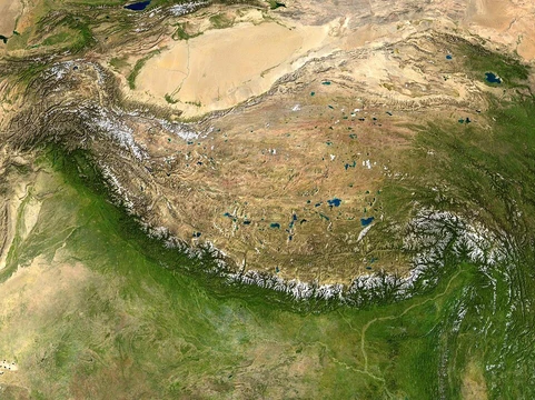
Geographers sort plateaus into three categories based on what borders them. Intermontane plateaus sit enclosed by fold mountain ranges and tend to be among the highest and most extensive on the planet. The Tibetan Plateau, wedged between the Himalayas and the Kunlun Mountains, and the Altiplano, nestled between two Andean ranges, are prime examples of this enclosed type. Piedmont plateaus occupy a transitional position, flanked by mountains on one side and a plain or sea on the other; the Piedmont Plateau in the eastern United States, stretching between the Appalachians and the Atlantic Plain, illustrates this arrangement well. Continental plateaus, by contrast, are ringed entirely by plains or oceans and develop independently of any nearby mountain system. The Antarctic Plateau in East Antarctica serves as a striking example of this third type, existing as a vast elevated surface with no surrounding highlands to define its edges.
Major Examples Across Continents
The world's most notable plateaus span every inhabited continent. In Africa, the Ethiopian Highlands dominate the central part of the country, forming the largest continuous high-altitude area on the continent, with most of its surface above 1,500 metres and peaks reaching 4,556 metres—earning it the nickname "Roof of Africa." The Highveld in South Africa, sitting between roughly 1,500 and 2,100 metres, supports some of the nation's largest urban clusters. In Asia, the Tibetan Plateau reigns as the largest and highest, covering about 2.5 million square kilometres at roughly 5,000 metres elevation, still being shaped by the ongoing collision of the Indo-Australian and Eurasian plates. Its height is sufficient to alter Hadley cell convection and drive Indian monsoons southward. In North America, the Colorado Plateau spans approximately 337,000 square kilometres across four U.S. states, and the Grand Canyon within it formed over millions of years as the Colorado River eroded downward at nearly the same pace the land rose—about a centimetre per year.
Gallery


Frequently Asked Questions
Who is Brazilian Highlands?
The Brazilian Highlands, also called the Brazilian Plateau (Planalto Brasileiro), is a vast elevated landmass stretching across the eastern, southern, and central parts of Brazil. It covers roughly 4.5 million square kilometres, making it one of the largest plateau regions on the planet.
What are Brazilian Highlands's powers/role?
Its main 'role' in the Brazilian landscape is serving as the home base for the overwhelming majority of the country's population, who live either on the plateau itself or along the narrow coastal strip bordering it. It also breaks into three major sub-regions: the Atlantic, Southern, and Central Plateaus.
How does Brazilian Highlands's story end?
The Highlands trace their origin to ancient basaltic lava flows that cooled and solidified into a broad, elevated surface. Over millions of years, erosion and tectonic activity carved those flows into the rolling, dissected terrain visible today.
Why is Brazilian Highlands important?
It occupies about half of Brazil's total land area, making it the single most dominant physical feature in the country. Its presence dictates where people settle, how rivers drain, and how climate and agriculture are distributed across the nation.
Where does Brazilian Highlands live?
The plateau dominates the eastern, southern, and central portions of Brazil, effectively forming the backbone of the country's interior. Its western edge meets the Amazon basin lowlands, while its eastern edge drops sharply down to the Atlantic coast.
More in Plateaus And Plains 1-24
Related in Plateaus And Plains
Links follow this subject's own source article.
Spotted an error? Know more?
This is a living reference — every entry is fact-audited, and reader corrections feed straight into our audit queue. Suggest an edit · See this site's audit record