Oxon Run Parkway
Federal park corridor with wetlands and the last McAteen magnolia bogs.
Last updated
Where it is
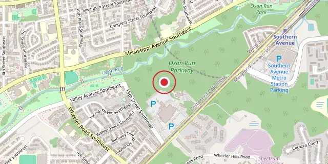
Coordinates: 38°50′17″N 76°59′06″W (38.8380, -76.9850) · Open in OpenStreetMap
Coordinates and connected clubs: the infobox of Wikipedia: Oxon Run Parkway (CC BY-SA 4.0). Map: drawn by Codexery from OpenStreetMap tiles.
The Oxon Run Parkway is a corridor of federal park land in the Washington Highlands neighborhood of Washington, D.C. The Parkway once extended across the District's southern corner in a crescent from Hillcrest Heights to Oxon Hill but most of it became Oxon Run Park in 1971, and now only the portion north of 13th Street still uses the Parkway name. It was originally intended to provide recreation space, but was later enlarged to provide flood relief, space for a major piece of sewer infrastructure and the possibility of a clean drinking water source.
The remaining Parkway is now 146 acres. It sits between Southern Avenue, Mississippi Avenue and 13th Street, SE and is now managed by the National Park Service. It contains wetlands, floodplains, springs, and forests as well as the only remaining McAteen magnolia bogs in the District of Columbia.
History
The Oxon Run Parkway was created by the National Capital Park and Planning Commission (NCPPC) to provide park space, allow for a sewer main, and prevent construction in the floodplain. Congress created the NCPPC in 1924 to develop a park and playground system, and by 1926 plans included land along Oxon Run. By 1930, the NCPPC had begun purchasing narrow strips along the stream, coinciding with a report identifying Oxon Run as a possible water source for Maryland.
After a 1937 flood, the NCPPC purchased 144 additional acres from the District line to the Camp Simms rifle range north of 14th, widening the Parkway above the high water mark. This allowed construction of the Oxon Run interceptor sewer, completed in 1939. Expansion continued with 40 acres purchased in 1939, 64 in 1940, over 11 acres later in 1940 and 1941, 20 acres in 1942, and 2.5 acres in 1944, ending the eight-year flood control project. At that point the Parkway extended across the entire District except for the portion within Camp Simms.
In 1946, President Truman signed an amendment to the Capper-Crampton Act calling for the Parkway to be extended into Maryland from the District Line to Marlboro Pike, but the Maryland-National Capital Park and Planning Commission carried out the extension, which never became part of the Parkway nor extended past Suitland Parkway.
Proposed road
The Oxon Run Parkway name has largely disappeared from road signs. A portion built in Hillcrest Heights, Maryland, was renamed Oxon Run Drive.
In 1942, a section in Dillon Park became 53rd Avenue, and after 1981 it became Dewitt Avenue. Today, only a short road in District Heights, Maryland, off Scott Key Drive, still carries the Oxon Run Parkway name. In 1946, the NCPPC voted to reclassify several parkways as "parks" because they lacked a road running through them, but the Oxon Run Parkway name remained in common use.
Did You Know?
- 94 acres of the Parkway were originally part of the Camp Simms rifle range.
- In July 1994, Metro workers digging wells for the Green Line tunnel discovered 6 Stokes mortar rounds, leading to a two-year cleanup that found 74 pieces of live ammunition.
More in National Park Service Areas in Washington, D.C.
Sources
Compiled from Wikipedia and the sources listed below. Text from Wikipedia is available under CC BY-SA 4.0; this entry is adapted from it.
- Wikipedia: Oxon Run Parkway (CC BY-SA 4.0).
Spotted an error? Know more?
Reader corrections go straight into our review queue. Suggest an edit · How this site is sourced