Battery Kemble Park
Civil War battery turned park in Northwest D.C.
Last updated

via Wikipedia: Battery Kemble Park · see source
Where it is
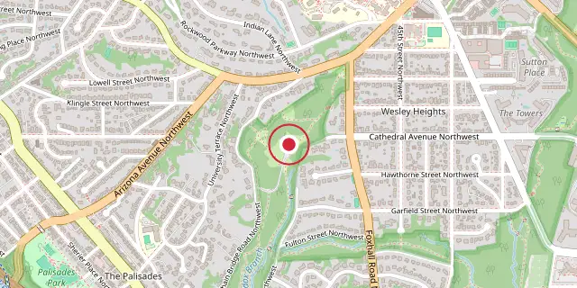
Coordinates: 38°55′48″N 77°05′38″W (38.9300, -77.0940) · Open in OpenStreetMap
Coordinates and connected clubs: the infobox of Wikipedia: Battery Kemble Park (CC BY-SA 4.0). Map: drawn by Codexery from OpenStreetMap tiles.
Battery Kemble Park is a National Park Service-administered park in Northwest Washington, D.C., located in the Palisades neighborhood. It preserves the site of a Union Army defensive battery from the Civil War, where two 100-pound Parrott rifles were positioned to guard Chain Bridge, Aqueduct Bridge, and Virginia. The park is used for running, sledding, and nature walks.
Quick Facts
- Location
- Washington, D.C.
Facts from the source article.
Civil War defenses of Washington, or 'Fort Circle'
Battery Kemble was finished in the fall of 1861 as part of the Civil War Defenses of Washington, often called the Fort Circle. It was named for Gouverneur Kemble, who had overseen the West Point Foundry, the place where most of the heavy guns for the Army and Navy were produced during the war. The battery sat on a high ridge, 387 feet above the Potomac River’s mean low water level, so its guns could cover both Chain Bridge and Aqueduct Bridge. The artillery could fire up to three miles, with direct fire effective within at least 1,000 yards of the fortifications.
The earthen remains are still clear and well preserved. This battery was part of a line of defenses guarding the D.C. side of Chain Bridge, alongside Battery Cameron, Battery Parrott, Battery Martin Scott, and Battery Vermont. It was meant to back up Fort Stevens and Fort Slocum and to protect the northern approaches to the city. The garrison during the war included the 2nd U.S. Artillery, the 9th New York Heavy Artillery, and Company A of the 1st New Hampshire Heavy Artillery.
An 1861 Army report noted the initial conditions, and as late as 1864 the soldiers’ quarters at Battery Kemble were still unfinished and short of supplies. Augusta Weaver, a well-off woman living nearby, wrote that soldiers stationed there raided local pantries, including her own. The land for the battery was given up to the U.S. government by William A.T. Maddox, a career Marine Corps officer.
Fort Parks and Fort Drive
Battery Kemble had a prominent place in 1950s- and 1960s-era plans for Fort Drive, a ring-shaped parkway concept first conceived in the early twentieth century to connect D.C.'s Civil War defenses. On October 24, 1944, the National Park Service and the District of Columbia signed a memorandum of agreement for the development of two Fort Drive sections, the first from MacArthur Boulevard to Nebraska Avenue. National Park Service Associate Director A.E. Demaray informed the Secretary of the Interior that 98 percent of the Fort Drive right-of-way had been acquired and that its construction was believed to be of first importance.
By May 1965, a new proposal by Fred Tuemmler, hired by the National Capital Planning Commission to re-evaluate Fort Drive, suggested the right-of-way land be reconstituted as a recreational facility and renamed the Fort Park System. Tuemmler envisioned a 30-mile ring of recreation and green space around the city, from Fort Greble Park to Battery Kemble Park, with hiking and bicycle paths.
Did You Know?
- The park is home to a chestnut oak rated as the largest known tree of its species in the United States.
- The earthworks slope was depicted in a 1989 landscape painting by David Holt titled Hillside in Battery Kemball [sic] Park, Washington, D.C.
- The park is policed by the United States Park Police (District 3), the Metropolitan Police Department (2nd District), and occasionally the U.S. Secret Service.
More in National Park Service Areas in Washington, D.C.
Sources
Compiled from Wikipedia and the sources listed below. Text from Wikipedia is available under CC BY-SA 4.0; this entry is adapted from it.
- Wikipedia: Battery Kemble Park (CC BY-SA 4.0).
Spotted an error? Know more?
Reader corrections go straight into our review queue. Suggest an edit · How this site is sourced