Meridian Hill Park
Urban park with Italianate design, cascading fountain, and historic statues.
Last updated
Where it is
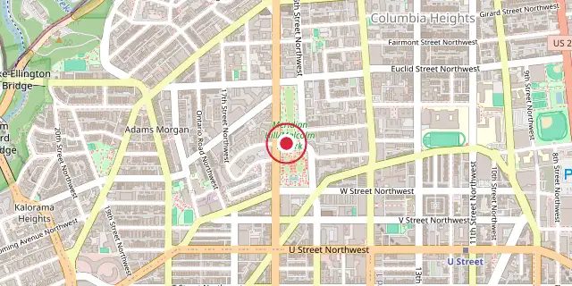
Coordinates: 38°55′16″N 77°02′10″W (38.9210, -77.0360) · Open in OpenStreetMap
Coordinates and connected clubs: the infobox of Wikipedia: Meridian Hill Park (CC BY-SA 4.0). Map: drawn by Codexery from OpenStreetMap tiles.
Meridian Hill Park, also known as Malcolm X Park, is an 11.88-acre urban park in Washington, D.C., situated on a prominent hill 1.5 miles directly north of the White House. The park was added to the National Register of Historic Places in 1974 and designated a National Historic Landmark in 1994. It is also a central feature of the Meridian Hill Historic District, added to the NRHP in 2014. The park's Italianate design was based on Italian gardens and parks visited by landscape architects George Burnap and Horace Peaslee during a European tour.
History
The earliest known inhabitants of the land beneath present-day Meridian Hill Park were the Nacotchtank tribe, who by 1700 had either been chased away by white settlers or died from introduced diseases. In 1816, Commodore David Porter purchased the land, then known as Peter's Hill, and renamed it Meridian Hill, after the geodetic marker placed there in 1804 to establish a longitudinal meridian for the city and nation. Porter built a mansion on the hill, which was later occupied by President John Quincy Adams.
During the American Civil War, the mansion and surrounding land were commandeered by the Union Army and hosted Camp Cameron. The mansion was destroyed in a fire in 1863. The land was subdivided after the war and a black community developed there, eventually encompassing almost three dozen houses and two grocery stores. Wayland Seminary's large school building was constructed on the northeast corner of the present-day park, but demolished after the school relocated.
After Mary Foote Henderson and her husband built Henderson Castle across the street from Meridian Hill, she purchased surrounding lots and began developing the area, catering to wealthy residents. She used her influence with members of Congress in her efforts, but was unsuccessful in having a new presidential mansion and the Lincoln Memorial being built on Meridian Hill. After the McMillan Plan was published in 1902, efforts were made to build a park on the hill.
No action was taken until 1910 when Congress authorized its establishment. Landscape architect George Burnap designed the park's initial plan, but after he was dismissed, his assistant Horace Peaslee took over the project and continued to oversee its completion. Construction of the park took place from 1912 to 1936. During these years, five statues and memorials were erected in the park, including the James Buchanan Memorial.
Geography
Meridian Hill Park sits on 11.88 acres at the top of the Wicomico-Sunderland escarpment, in the neighborhood that straddles Adams Morgan and Columbia Heights. Its boundaries are 15th Street NW to the east, 16th Street NW to the west, Euclid Street NW to the north, and W Street NW to the south. The White House is located 1.5 miles directly south of the park. The park splits into an upper northern section and a lower southern section, with the ground dropping about 75 feet from Euclid Street down to W Street.
It faces south, and from its original position it offered wide views of the city. The rectangular layout uses a central axis and a cross axis, which break the space into asymmetrical parts. The lower level is broader than the upper, so the axis and overall design tilt slightly to the southeast. A large retaining wall separates the two levels.
On the upper level, an open lawn sits between sidewalks and trees, with a big terrace that looks down over the lower section. The sidewalks on each side of the lawn were once called Monument Vista Walk on the east and Concert Promenade on the west.
Winding paths run along the eastern and western edges, beyond the tree lines. The lower level holds a reflecting pool, a plaza, and a cascade fountain with stairways on either side. An additional stairway lies on the park’s western edge, and a winding path runs along its eastern edge.
Public artwork
The park contains five statues and memorials erected during its construction from 1912 to 1936, including the James Buchanan Memorial. Architectural sculptor and carver John Joseph Earley used a then-new type of building material, concrete aggregate, in the park's walls, benches, fountains, and balustrades. The lower level features a reflecting pool, plaza, and a cascade fountain flanked by stairways.
Did You Know?
- President John Quincy Adams lived in the mansion on the hill for a few months in 1829.
- A drum circle that began after the assassination of Malcolm X still takes place at the park.
More in National Park Service Areas in Washington, D.C.
Sources
Compiled from Wikipedia and the sources listed below. Text from Wikipedia is available under CC BY-SA 4.0; this entry is adapted from it.
- Wikipedia: Meridian Hill Park (CC BY-SA 4.0).
Spotted an error? Know more?
Reader corrections go straight into our review queue. Suggest an edit · How this site is sourced