King Arthur's Cave
Last updated

via Wikipedia: King Arthur's Cave · see source
Where it is
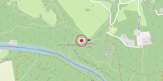
Coordinates: 51°50′13″N 2°39′43″W (51.8370, -2.6620) · Open in OpenStreetMap
Coordinates and connected clubs: the infobox of Wikipedia: King Arthur's Cave (CC BY-SA 4.0). Map: drawn by Codexery from OpenStreetMap tiles.
Tucked into a low cliff at the northwestern edge of Lord's Wood in The Doward, near Symonds Yat, Herefordshire, King Arthur's Cave sits about 285 feet above the River Wye. Its double, interconnected entrance opens into two main chambers. This limestone cave, protected as a nature reserve by the Herefordshire Nature Trust, shows signs of human activity during the Upper Palaeolithic. Excavations have uncovered flint tools and woolly mammoth bones within and around the cave.
Quick Facts
- Location
- Lord's Wood, The Doward, Symonds Yat, England
Facts from the source article.
Background
No one is quite sure how King Arthur's Cave got its name. A story from around 1700 claims a giant human skeleton was found inside, but it vanished when a local surgeon, Mr. Pye, took it on a ship to Jamaica that sank. The cave is wrapped in local folklore, with ties to the early legend of King Vortigern, a British ruler who fought the invading Anglo-Saxons. He is said to have made his final stand against Aurelius at nearby Ganarew.
The poet Lawman wrote of a castle on Cloard Hill in the district of Hergin, where Vortigern died after Aurelius and Uther besieged and set it on fire. In her 1969 book The Realms of Arthur, Helen Hill Miller proposed the cave was used for military purposes, noting its deep recesses could hide a large force. Like Cadbury Castle, this cave sits inside a hillfort.
Excavations
In 1871, Reverend William S. Symonds excavated the caves after learning that miners had raided them. He unearthed bones of hyena, lion, brown bear, red deer, rhinoceros, Irish Elk, reindeer, and horse from the Late Pleistocene, with hyena evidence particularly prominent and many bones showing signs of being crunched by them. He also found Upper Palaeolithic flint implements and fragments of Neolithic pottery. Members of the Cotswold Naturalists' Field Club explored the caves under Symonds' supervision, leading to further discoveries.
Between 1925 and 1927, the University of Bristol Spelæological Society excavated here, and in 1926 Garrod dated findings in the upper cave to the Upper Palaeolithic and those from the lower cave to the Middle Palaeolithic. The society returned in 1955 but found nothing new. In 1989, the caves and the Upper Wye Gorge of about 1.5 hectares was designated a SSSI.
More in Locations Associated with Arthurian Legend
Sources
Compiled from Wikipedia and the sources listed below. Text from Wikipedia is available under CC BY-SA 4.0; this entry is adapted from it.
- Wikipedia: King Arthur's Cave (CC BY-SA 4.0).
- Word definitions: the Codexery glossary, each quoted from its Wikipedia article.
Spotted an error? Know more?
Reader corrections go straight into our review queue. Suggest an edit · How this site is sourced