Alderley Edge
Last updated

via Wikipedia: Alderley Edge · see source
Where it is
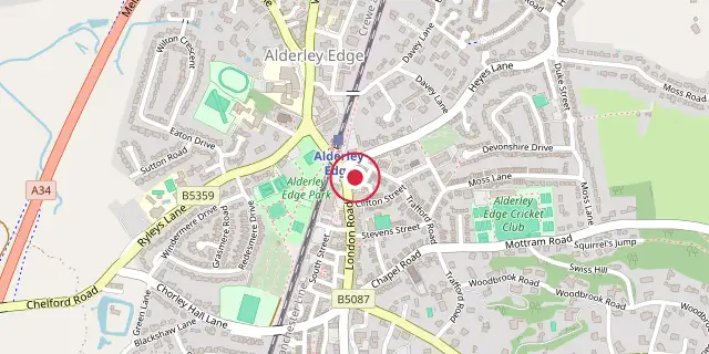
Coordinates: 53°18′11″N 2°14′10″W (53.3030, -2.2360) · Open in OpenStreetMap
Coordinates and connected clubs: the infobox of Wikipedia: Alderley Edge (CC BY-SA 4.0). Map: drawn by Codexery from OpenStreetMap tiles.
Alderley Edge, a village and civil parish in Cheshire, sits 6 miles northwest of Macclesfield and 12 miles south of Manchester, at the foot of a wooded sandstone ridge called The Edge that looks out over the Cheshire Plain. Its 2021 population was 4,777. Known for its wealth, expensive homes, and location in Cheshire's Golden Triangle, the village draws Premier League footballers, actors, and businesspeople to its cafes and designer shops, making it one of the UK's most desirable places to live outside London.
History
Alderley Edge is a village and civil parish in Cheshire, England, lying 6 miles north-west of Macclesfield and 12 miles south of Manchester. It sits at the foot of a wooded sandstone ridge called The Edge, which looks out over the Cheshire Plain.
According to the 2021 census, 4,777 people live there. The village is known for its wealth, expensive houses, and location within Cheshire's Golden Triangle. Its cafes and designer shops attract Premier League footballers, actors, and businesspeople, making it one of the most desirable places to live in the UK outside London.
Early period
People have lived in the Alderley Edge area since the Mesolithic period, as shown by flint tools found along the sandstone outcrop. There is evidence of Bronze Age copper mining south of the area. In 1995, the Derbyshire Caving Club found a hoard of 564 Roman coins dating from AD 317 to 336, which is now kept at the Manchester Museum. The County Sites and Monuments Record lists 13 sites in Alderley Edge, 28 in Nether Alderley, and 44 along The Edge.
Early medieval settlements were recorded in Nether Alderley, south of Alderley Edge. The first written record of Alderley Edge, then called Chorlegh (later Chorley), comes from the 13th century; the name likely comes from ceorl and lēah, meaning a "peasants' clearing." It does not appear in the Domesday Book but is mentioned in a charter from around 1280. The name Alderley was first recorded in 1086 as Aldredelie, probably from Aldred and leah, meaning "Aldred's clearing," or from the Old English Alðrȳðelēah, meaning "the meadow or woodland clearing of a woman called Alðrȳð."
During the 13th century and the Middle Ages, the area consisted of several estates, mostly owned by the De Trafford baronets from the 15th century. The main manors were Chorley Old Hall, built in the 14th century, and Nether Alderley's Old Hall, a 16th-century building destroyed by fire in 1779. Farming was the main part of the local economy, and Nether Alderley was given a market charter around 1253. Nether Alderley Mill dates back to 1391, though the current timber structure is from the 16th century.
The millpond was turned into a moat around the Old Hall, home of the Stanley family. The corn mill kept working until 1939, when Edward Stanley, 6th Baron Stanley of Alderley, was forced to sell it and the rest of the Alderley Park estate to pay death duties. In the 1950s, the National Trust bought the site, restored the building, and opened it to the public. In the medieval period, Cheshire had its own tax system called the Mize; records from 1405 show Chorley was assessed at 20 shillings and Nether Alderley at 27 shillings.
19th century
In 1830, Chorley was just a few cottages, the De Trafford Arms Inn, a toll bar, and a smithy spread along the Congleton to Manchester Road. The railway arrived in 1842 as part of the Manchester and Birmingham Railway and changed the area completely. The railway company offered free 20-year season tickets to Manchester businessmen who built homes worth more than £50 within a mile of the station. These tickets were small silver ovals worn on watch chains and encouraged development.
The station was first called 'Alderley,' then renamed 'Alderley and Chorley' in 1853, and finally 'Alderley Edge' in 1876. After the railway was built, Sir Humphrey de Trafford, who owned Chorley Hall, developed an estate with new roads and houses, most finished by 1910. The railway also made the village popular for day trips and excursions. Several important buildings went up during this time, including St Philip's Church in 1853, Alderley Edge Community Primary School in 1854, and The Ryleys School for boys in 1877.
Two all-girls schools opened: St Hilary's in 1876 and Mount Carmel in 1945, which merged in 1999 to form Alderley Edge School for Girls. The Mission Hall (later The Institute) was built in 1878 for temperance meetings, and the Methodist Church was built in 1863. The population of Alderley Edge rose from 561 in 1841 to 2,856 by 1902, while Nether Alderley's fell from 679 to 522.
The 1871 Ordnance Survey map shows the village with the Queen's Hotel, shops, terraced houses, and a post office. To the north were wooded areas with detached villas, and to the east, curving roads divided large wooded plots, some still undeveloped. The names "Brickfield" and "Brick Kiln" to the northeast suggest a local source of bricks. The 1899 map shows a similar layout but names individual villas like Holybank, Ashfield, and The Larches, along with remains of old mines near Windmill Wood to the southeast.
20th century
In the 20th century, Alderley Edge grew with post-war housing on its north-eastern and western edges, while Nether Alderley stayed mostly the same, except for the sale of Alderley Park to AstraZeneca. The park is now managed by Bruntwood and houses 150 science companies, as well as commercial, residential, and retail spaces. In the 1990s, several gold bars were found in Alderley, the first on Artists Lane.
An inquest in February 1993 declared it was not a treasure trove. John Cherry from the British Museum and Adrian Tindall, the conservation officer for Cheshire County Council, reported that the bar weighed 97.01 grams and was 73% gold. The publicity led the public to search for more, and five more gold bars were found.
There are two levels of local government for Alderley Edge: Alderley Edge Parish Council and Cheshire East Council. The parish council meets at Festival Hall on Talbot Road. The settlement now called Alderley Edge was historically known as Chorley and was part of the ancient parish of Wilmslow in the Macclesfield Hundred of Cheshire.
Governance
There are two tiers of local government covering Alderley Edge, at civil parish and unitary authority level: Alderley Edge Parish Council and Cheshire East Council. The parish council meets at Festival Hall on Talbot Road. The settlement now known as Alderley Edge was historically called Chorley and was part of the ancient parish of Wilmslow in the Macclesfield Hundred of Cheshire. Wilmslow parish was divided into four townships: Bollin Fee, Chorley, Fulshaw, and Pownall Fee.
Administrative history
Alderley parish, lying south of Chorley; consisted of three townships: Nether Alderley, Over Alderley, and Great Warford. From the 17th century, parishes gradually acquired civil functions under the poor laws, in addition to their original ecclesiastical functions. In some cases, including Wilmslow and Alderley, the civil functions were exercised by each township separately rather than the parish as a whole. In 1866, the legal definition of 'parish' was changed to be the areas used for administering the poor laws, and so Chorley and all the other townships became separate civil parishes, which therefore diverged from the ecclesiastical parishes.
In 1862, a Chorley local government district was established, governed by an elected local board, covering parts of Chorley, Bollin Fee and Fulshaw. The more rural western part of Chorley was excluded. In 1894, the board renamed the district to Alderley Edge to avoid postal confusion with Chorley, Lancashire and became an urban district under the Local Government Act 1894. The 1894 Act also directed that civil parishes could no longer straddle district boundaries, and so the part of Chorley within the urban district became a separate parish called Alderley Edge, and the parts of Bollin Fee and Fulshaw within the urban district became a parish called Bollinfee.
The reduced civil parish of Chorley outside the urban district kept the name Chorley, despite no longer including the village after which it was named. The urban district expanded in 1910, gaining area from Nether Alderley and 1936, taking small areas from Wilmslow and Chorley. In 1974, Alderley Edge Urban District was abolished under the Local Government Act 1972, with a successor parish established covering the same area. District-level functions passed to Macclesfield Borough Council, and in 2009, Cheshire East Council took over as the Borough council and Cheshire County Council were both abolished.
Landmarks
The Edge is a wooded sandstone escarpment overlooking the Cheshire Plain. A folly stone circle known as the Druid's Circle sits on The Edge, probably placed there in the 19th century.
Notable residents
Notable residents connected to Alderley Edge include Arthur Penrhyn Stanley (1815–1881), Anglican priest and historian who became Dean of Westminster; Sir Kenneth Stewart, 1st Baronet (1882–1972), president of Trustee Savings Banks Association; and Lady Katharine Chorley (1897–1986), writer and mountaineer brought up in the village. Musicians include Bernard Sumner (born 1956) and Peter Hook (born 1956), co-founders of Joy Division; Tim Healy (born 1952), actor; and Matty Healy (born 1989), singer-songwriter who spent his formative years there.
Other residents include Victoria Beckham (born 1974), fashion designer and former Spice Girl; Denise Welch (born 1958), actress and TV personality; Richard Fleeshman (born 1989), actor; Helen Flanagan (born 1990), actress; and Charlotte Owen, Baroness Owen of Alderley Edge (born 1993), life peer. The Pilkington family of Pilkington's Glass owned all the woodland now known as The Edge until 1948, when their daughters donated it to the National Trust.
Architect J. Henry Sellers (1861–1954) spent his later life at Bollin Tower. Bridge designer and chess master William Fairhurst (1903–1982) was born in Alderley Edge, as were footballer Harry Burgess (1904–1957) and BBC sports commentator David Coleman (1926–2013).
Did You Know?
- In the 1990s, several gold bars were found in Alderley; the first weighed 97.01 grams and was 73% gold.
- Nether Alderley Mill dates back to 1391, though the present timber structure is 16th-century, and it continued working until 1939.
- Alderley Edge's population rose from 561 in 1841 to 2,856 by 1902.
More in Locations Associated with Arthurian Legend
Sources
Compiled from Wikipedia and the sources listed below. Text from Wikipedia is available under CC BY-SA 4.0; this entry is adapted from it.
- Wikipedia: Alderley Edge (CC BY-SA 4.0).
Spotted an error? Know more?
Reader corrections go straight into our review queue. Suggest an edit · How this site is sourced