Dumbarton Castle
Last updated

via Wikipedia: Dumbarton Castle · see source
Where it is
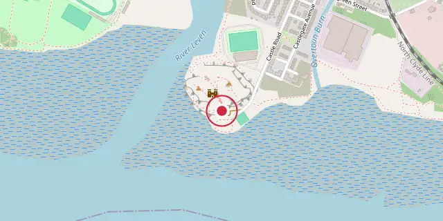
Coordinates: 55°56′10″N 4°33′47″W (55.9360, -4.5630) · Open in OpenStreetMap
Coordinates and connected clubs: the infobox of Wikipedia: Dumbarton Castle (CC BY-SA 4.0). Map: drawn by Codexery from OpenStreetMap tiles.
Dumbarton Castle, known in Gaelic as Dùn Breatainn and historically as Alt Clut, occupies a volcanic plug of basalt called Dumbarton Rock, which rises 240 feet above the Scottish town of Dumbarton. It holds the longest recorded history of any stronghold in Scotland.
History
Dumbarton Rock was formed between 330 and 340 million years ago during the Early Carboniferous period, when volcanic activity in the area that now contains Glasgow left a basalt plug after the softer exterior weathered away. Archaeological evidence indicates the site was a strategically important settlement as far back as the Iron Age. Its inhabitants during Roman Britain traded with the Romans. The first written record of a settlement there is a late-5th-century letter from Saint Patrick to King Ceretic of Alt Clut.
David Nash Ford has proposed that Dumbarton was the Cair Brithon ('Fort of the Britons') listed by Nennius among the 28 cities of Sub-Roman Britain. From the 5th to the 9th century, the castle served as the centre of the independent Brythonic Kingdom of Strathclyde; the Brythonic name Alt Clut became a metonym for the kingdom.
Merlin is said to have stayed at Alt Clut. In the triads of the Red Book of Hergest, the third 'Unrestrained Ravaging' describes Aeddan Fradog coming to the court of Rhydderch the Generous at Alclud, leaving nothing alive. This battle also appears in stories of Myrddin Wyllt, possibly conflated with the battle of Arfderydd.
Preservation
No visible traces of the Dark-Age Alt Clut remain. Surviving medieval elements include the 14th-century Portcullis Arch, foundations of the Wallace Tower, and what may be the foundations of the White Tower. A 16th-century guard house bears a face said to be 'Fause Menteith', who betrayed William Wallace.
Most existing structures date from the 18th century, such as the Governor's House built for John Kennedy, 8th Earl of Cassilis, and fortifications that show the difficulty of adapting the site to contemporary defence. The castle is open daily in summer and Saturday–Wednesday in winter; 627 steps lead to the summit of the White Tower Crag. Dumbarton Rock is a Scheduled Ancient Monument in state ownership.
Did You Know?
- In 871, Viking kings Amlaíb Conung and Ímar laid siege to Dumbarton Rock; it fell in four months after its water supply failed.
- The medieval Scalacronica records the legend that Arthur left his nephew Hoël of Brittany sick at Alcluit (Dumbarton).
- In 1505, a sword that had belonged to William Wallace was repaired at Dumbarton Castle.
More in Locations Associated with Arthurian Legend
Sources
Compiled from Wikipedia and the sources listed below. Text from Wikipedia is available under CC BY-SA 4.0; this entry is adapted from it.
- Wikipedia: Dumbarton Castle (CC BY-SA 4.0).
Spotted an error? Know more?
Reader corrections go straight into our review queue. Suggest an edit · How this site is sourced