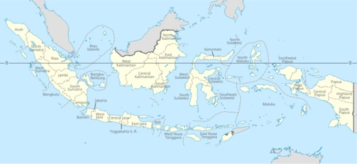
North Maluku
Province in eastern Indonesia, site of the 2026 Molucca Sea earthquake.

via Wikipedia: 2026 North Maluku earthquake · see source
North Maluku is a province of Indonesia situated in the northern portion of the Maluku Islands. Its maritime boundaries touch the Pacific Ocean to the north, the Halmahera Sea to the east, the Molucca Sea to the west, and the Seram Sea to the south. The province shares sea borders with North Sulawesi and Central Sulawesi to the west, the province of Maluku to the south, Southwest Papua to the east, and the nation of Palau to the north. The capital is Sofifi, located on the island of Halmahera and administratively part of the city of Tidore Islands, while the largest city is Ternate, situated on its own island. According to the 2010 census, the population was just over one million, rising to nearly 1.28 million by the 2020 census, with an official mid-2025 estimate of approximately 1.37 million. Historically, this region was the heartland of four major Islamic sultanates—Bacan, Jailolo, Tidore, and Ternate—collectively known as the Moloku Kie Raha, or the Four Mountains of Maluku. These kingdoms formed a confederation likely emerging in the 14th century, centered on the clove-producing islands west of Halmahera. The arrival of Europeans in the early 1500s sparked competition among the Portuguese, Spanish, and Dutch for control of the spice trade, with the Dutch ultimately prevailing and establishing three centuries of colonial rule. During World War II, the Japanese invaded, making Ternate a hub for their Pacific administration. After Indonesian independence, the area was part of the province of Maluku until North Maluku was officially established as a separate province on 12 October 1999. The economy relies heavily on agriculture, fisheries, and marine products, with key commodities including copra, nutmeg, cloves, gold, and nickel, alongside crops like rice, corn, sago, and eucalyptus.
- Capital
- Sofifi
- Largest City
- Ternate
Lore & Background
The 2 April 2026 earthquake struck the Molucca Sea between North Sulawesi and North Maluku Provinces, with its epicenter near the Batang Dua Islands. According to the United States Geological Survey (USGS), the earthquake had a magnitude of Mww 7.4 at a depth of 35.0 km. The focal mechanism corresponded to reverse faulting, with a rupture area of 100 km x 55 km estimated to have ruptured directly through the Batang Dua Islands. The maximum slip was 1.0241 m west of the hypocenter, and the source time function gave a 30-second duration, with the greatest phase of seismic moment release occurring about 15 seconds after initiation. The Modified Mercalli intensity reached VIII (Severe) in the Batang Dua Islands. The earthquake was followed by at least 1,378 aftershocks, 25 of them felt, with the largest having a magnitude of Mwb 6.2. A 75 cm tsunami was observed in North Minahasa Regency.
Reader's Guide
For visitors and residents of North Maluku, the 2026 earthquake provides a concrete example of the region's seismic activity. The Batang Dua Islands, part of Ternate city, experienced the most severe shaking at MMI VIII. One person died after a sports centre collapsed in Manado, and two others were injured there. In the Batang Dua Islands, one person was injured and 1,966 others were displaced. Across the islands, 104 homes collapsed, 85 were moderately damaged, and 79 were slightly damaged. Six churches, a school, and two public facilities were destroyed, with eight more churches damaged. On Ternate Island, at least 23 homes were affected, and in Bitung, 41 structures were damaged. Across Halmahera, two homes collapsed, and 12 others, a bridge, and a school were damaged. On Tidore, at least 27 homes collapsed, and 25 others, five places of worship, and a public facility were damaged. In Minahasa Regency, one person was injured, and 17 homes, three buildings, and a road were damaged. Several roads in Gorontalo were damaged or struck by landslides.
Did You Know?
- The 2 April 2026 earthquake had a magnitude of Mww 7.4 according to the USGS, while the BMKG reported Mw 7.3.
- The earthquake's rupture area was estimated at 100 km x 55 km, rupturing directly through the Batang Dua Islands.
- A 75 cm tsunami was observed in North Minahasa Regency following the earthquake.
- The earthquake was followed by at least 1,378 aftershocks, 25 of which were felt.
- The largest aftershock had a magnitude of Mwb 6.2.
Frequently Asked Questions
Who is North Maluku?
North Maluku is a province in eastern Indonesia that occupies the northern half of the Maluku archipelago, with Sofifi as its administrative capital and Ternate as its most populous city. It was carved out of the larger Maluku province on 12 October 1999.
What are North Maluku's powers/role?
The province's economic toolkit centers on copra, nutmeg, cloves, fisheries, and the extraction of gold and nickel. Historically it also anchored four major Islamic sultanates—Bacan, Jailolo, Tidore, and Ternate—collectively known as the Moloku Kië Raha.
How does North Maluku's story end?
As a living province rather than a finished narrative, North Maluku has no fixed ending; its mid-2025 population is estimated at roughly 1.37 million residents. Its ongoing arc is shaped by its spice-trade heritage and a growing role in Indonesia's mineral supply chain.
Why is North Maluku important?
It served as the historic heartland of the four great sultanates of the eastern archipelago, making it a pivotal node in the centuries-long spice trade that drew global powers to the region. Today it remains a key Indonesian source of cloves, nutmeg, and industrial minerals.
When did North Maluku debut?
The province was officially established on 12 October 1999 through a separation from the province of Maluku. Its 2020 census recorded a population of 1,282,937 people.
More in Provinces Of Indonesia 1-24
Spotted an error? Know more?
This is a living reference — every entry is fact-audited, and reader corrections feed straight into our audit queue. Suggest an edit · See this site's audit record