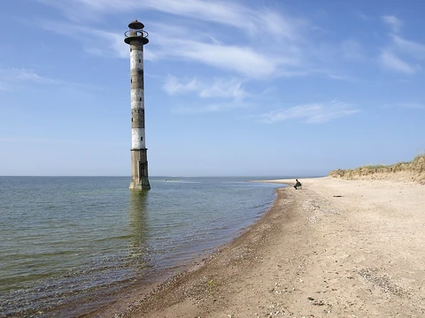
Seward Peninsula
Alaskan peninsula remnant of the Bering land bridge.

The Seward Peninsula juts roughly 200 miles (320 km) from Alaska’s western coast into the Bering Sea, bordered by Norton Sound, the Bering Strait, the Chukchi Sea, and Kotzebue Sound, just shy of the Arctic Circle. Its westernmost tip is Cape Prince of Wales. The landmass spans about 210 miles (330 km) in length and varies from 90 to 140 miles (145 to 225 km) in width. It bears the name of William H. Seward, the U.S. Secretary of State who championed the Alaska Purchase. Geologically, the peninsula is a surviving fragment of the Bering land bridge—a roughly 1,000-mile-wide corridor that connected Siberia to mainland Alaska during the Pleistocene Ice Age, enabling the movement of humans, plants, and animals from Asia into North America. Excavations at sites like the Trail Creek Caves, Cape Espenberg (within the Bering Land Bridge National Preserve), and Cape Denbigh to the south have shed light on the timing of these prehistoric migrations.
Most of the peninsula lies within the Nome Census Area, though a portion falls in the Northwest Arctic Borough. Communities include Nome, Shishmaref, Teller, Wales, Brevig Mission, White Mountain, Golovin, Elim, Koyuk, and Deering. Other spots—Council, Solomon, Candle, Haycock, and Taylor—were once mining towns but now lack year-round residents, though locals from nearby areas still visit. A U.S. Coast Guard LORAN station once operated at Port Clarence, and the U.S. Air Force maintains a radar station at “Tin City,” about 7 miles (11 km) southeast of Wales.
The peninsula’s geography features several notable volcanic formations. The Devil Mountain Lakes, in the north, are the world’s largest maar lakes, part of the Espenberg volcanic field and formed over 21,000 years ago by an underground steam explosion. The Killeak Lakes and White Fish Lake are also sizable volcanic maar lakes in the northern region. Four mountain ranges line the southern side, with the Kigluaik (or Sawtooth) Mountains being the most prominent; their highest peak, Mount Osborn, rises to 4,714 ft (1,437 m), the peninsula’s highest point. Other ranges include the Bendeleben, Darby, and York Mountains. The Bendeleben Mountains show signs of recent faulting from the late Cenozoic, though most tectonic deformation and mountain-building occurred during the Cretaceous, linked to regional block rotation of the Bering plate. The Lost Jim Lava Flow, north of Kuzitrin Lake, is a lava field covering roughly 88 square miles (230 km²) that formed about 1,000 to 2,000 years ago. Geothermal hot springs dot the area, including Serpentine, Pilgrim, Granite Mountain, Elim, Clear Creek, and Lava Creek.
Several rivers cross the peninsula, the largest being the Koyuk, Kuzitrin, Niukluk, Fish, Tubuktilik, Kiwalik, Buckland, and Agiupuk. These waterways are vital for subsistence living, supporting travel, hunting, and fishing. Most host annual runs of several salmon varieties, along with Dolly Varden trout, Arctic grayling, whitefish, northern pike, and burbot. They typically freeze in mid-October and break up in mid- to late May. The peninsula marks the westernmost limit for black spruce (Picea mariana), a dominant tree species in the region.
Reindeer herding has been concentrated on the Seward Peninsula since the first animals were imported from eastern Siberia in 1892. The peninsula’s geography was thought to prevent migrating caribou from mingling with domesticated reindeer, but in 1997, the domesticated herd joined the Western Arctic Caribou Herd on its summer migration and was lost. Cape Prince of Wales, the westernmost point of mainland North America, lies just 51 miles (82 km) from Cape Dezhnev on the Russian mainland. In August 2011, Russia announced a plan to build a rail tunnel under the Bering Strait, linking the Seward Peninsula to Russia’s Chukchi Peninsula—a project estimated at US$65 billion and, at 64 miles (103 km), the world’s longest tunnel.
- Location
- Western coast of Alaska, U.S.
- Length
- About 210 mi (330 km)
- Width
- 90–140 mi (145–225 km)
- Westernmost point
- Cape Prince of Wales
- Highest point
- Mount Osborn, 4,714 ft (1,437 m)
- Named after
- William H. Seward
- Notable feature
- Remnant of the Bering land bridge
Verified Timeline
Lore & Background
The Seward Peninsula is a large peninsula on the western coast of the U.S. state of Alaska, whose westernmost point is Cape Prince of Wales. It projects about 200 mi (320 km) into the Bering Sea between Norton Sound, the Bering Strait, the Chukchi Sea, and Kotzebue Sound, just outside the Arctic Circle. The entire peninsula is about 210 mi (330 km) long and 90–140 mi (145–225 km) wide. Like Seward, Alaska, it was named after William H. Seward, the United States Secretary of State who fought for the U.S. purchase of Alaska. The Seward Peninsula is a remnant of the Bering land bridge, a roughly thousand-mile-wide swath of land connecting Siberia with mainland Alaska during the Pleistocene Ice Age. This land bridge aided in the migration of humans, as well as plant and animal species, from Asia to North America. Excavations at sites such as the Trail Creek Caves and Cape Espenberg in the Bering Land Bridge National Preserve as well as Cape Denbigh to the south have provided insight into the timeline of prehistorical migrations from Asia to the Seward Peninsula. Most of the peninsula is in the Nome Census Area, but part is in the Northwest Arctic Borough. Other locations on the Seward Peninsula include the mining towns of Council, Solomon, Candle, Haycock and Taylor. While still frequented by locals of neighboring communities, there are no longer year round residents in these locations. There was a United States Coast Guard LORAN station at Port Clarence. The U.S. Air Force operates a radar station at the 'Tin City' site, 7 mi (11 km) southeast of Wales.
Reader's Guide
The Seward Peninsula holds significance as a key geographic and historical link between Asia and North America. As a remnant of the Bering land bridge, it provides critical evidence for the migration of humans, plants, and animals during the Pleistocene Ice Age. Archaeological sites such as the Trail Creek Caves and Cape Espenberg have helped researchers understand the timeline of these prehistoric movements. The peninsula's geology includes the Devil Mountain Lakes on the northern portion, which are the largest maar lakes in the world and part of the Espenberg volcanic field, formed over 21,000 years ago as the result of an underground steam explosion. The Killeak Lakes and White Fish Lake are also volcanic maar lakes of notable size on the northern Seward Peninsula. The highest point in the peninsula is the peak of 4,714 ft (1,437 m) Mount Osborn in the Kigluaik (or Sawtooth) Mountains. The Lost Jim Lava Flow north of Kuzitrin Lake is a lava field formed roughly 1,000 to 2,000 years ago, covering roughly 88 sq mi (230 km2). The Seward Peninsula is the westernmost limit of distribution for the black spruce, Picea mariana. Alaska's reindeer herding was concentrated on the Seward Peninsula ever since the first shipment of reindeer were imported there from eastern Siberia in 1892. However, in 1997 the domesticated reindeer joined the Western Arctic Caribou Herd on their summer migration and disappeared. Cape Prince of Wales, the westernmost point on the mainland of the Americas, is on the western tip, only 51 mi (82 km) from Cape Dezhnev, the closest point on the Russian mainland. In August 2011 Russia announced an ambitious project to construct a rail tunnel under the Bering Strait, linking the Seward Peninsula in Alaska with the Chukchi Peninsula in Russia, which would cost an estimated US$65 billion and would be the world's longest tunnel at 64 mi (103 km) long.
Did You Know?
- The Devil Mountain Lakes on the northern Seward Peninsula are the largest maar lakes in the world, formed over 21,000 years ago by an underground steam explosion.
- The highest point on the peninsula is Mount Osborn, at 4,714 ft (1,437 m) in the Kigluaik Mountains.
- Cape Prince of Wales, the westernmost point on the mainland of the Americas, is only 51 mi (82 km) from Cape Dezhnev on the Russian mainland.
- In 1997, domesticated reindeer on the Seward Peninsula joined the Western Arctic Caribou Herd on their summer migration and disappeared.
- The Lost Jim Lava Flow north of Kuzitrin Lake covers roughly 88 sq mi (230 km2) and formed 1,000 to 2,000 years ago.
Frequently Asked Questions
What exactly is the Seward Peninsula?
It is a broad landmass jutting into the Bering Sea along Alaska's western coastline, stretching roughly 210 miles in length and 90 to 140 miles in width. Geologically, it is a surviving fragment of the Bering land bridge that once linked Siberia to North America during the Pleistocene Ice Age.
Who is the Seward Peninsula named after?
The peninsula honors William H. Seward, the U.S. Secretary of State who championed and secured America's purchase of Alaska from Russia.
What is the westernmost point of the Seward Peninsula?
Cape Prince of Wales sits at the far western tip, marking where the peninsula's edge meets the Bering Sea.
What is the highest elevation on the Seward Peninsula?
Mount Osborn, rising to about 4,714 feet (1,437 m), is the peak that crowns the peninsula's landscape.
Why does the Seward Peninsula matter in the story of human migration?
As a remnant of the Bering land bridge, it represents the ancient terrestrial corridor through which early humans, along with plants and animals, crossed from Asia into the Americas during the Ice Age.
More in Peninsulas And Capes 1-24
Spotted an error? Know more?
This is a living reference — every entry is fact-audited, and reader corrections feed straight into our audit queue. Suggest an edit · See this site's audit record