
Great Hungarian Plain
Plain occupying most of Hungary, largest part of the wider Pannonian Plain.

via Wikipedia: Great Hungarian Plain · see source
The Great Hungarian Plain, called the Alföld or Great Alföld in Hungarian, covers most of modern Hungary. It is the largest section of the wider Pannonian Plain, though it was never part of the ancient Roman province of Pannonia. After World War I and the 1920 Treaty of Trianon, new political borders cut into its eastern and southern edges, making the plain significantly smaller.
To the north and east, the plain is bordered by the Carpathian Mountains. The Transdanubian Mountains and the Dinaric Alps lie to the southwest, and the Sava River roughly marks its southern limit.
Hungarian geographers often dispute the term "Pannonian Basin" for the wider area, calling it historically inaccurate. The Roman province of Pannonia was bounded on its north and east by the Danube River, so the Great Hungarian Plain clearly lay outside that province.
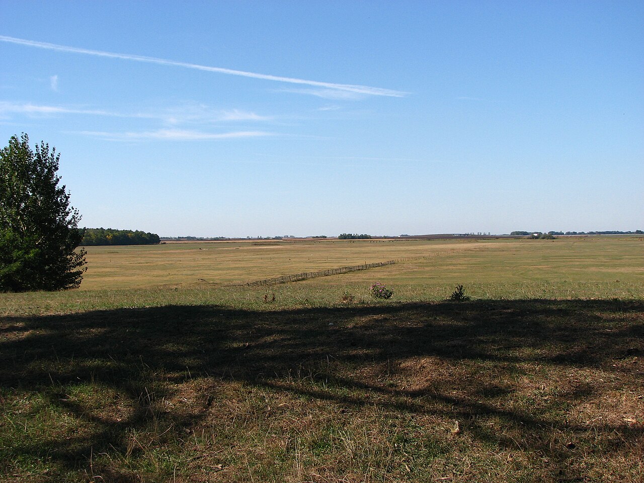
Within Hungary, the plain covers about 52,000 square kilometers, roughly 56 percent of the country’s total area. Its highest point is Hoportyó at 183 meters, and its lowest is along the Tisza River. The landscape ranges from flat to rolling plains.
The Tisza is the plain’s most important river. Notable writers inspired by the region include Ferenc Móra, Zsigmond Móricz, and poets Sándor Petőfi and Gyula Juhász. Scientists born here include physicist Zoltán Bay, chemist János Irinyi (inventor of the noiseless match), pharmacologist János Kabay, physician and pharmacist Gábor Kátai, and physician Frigyes Korányi. Cities and towns with medicinal baths include Debrecen, Berekfürdő, Cserkeszőlő, Gyula, Hajdúszoboszló, Orosháza, Szentes, and Szolnok. Cultural festivals in the region include the Csángófesztivál in Jászberény, the Cseresznyefesztivál in Nagykörű, the Gulyásfesztivál in Szolnok, the Hídi Vásár in Hortobágy National Park, the Hunniális at Ópusztaszer, the Szabadtéri Játékok in Szeged, the Várjátékok in Gyula, the Virágkarnevál in Debrecen, and the Bajai Halászléfőző Népünnepély in Baja.
In Serbia, the term refers to the Hungarian part of the Pannonian plain. The Serbian portion is mostly divided into Bačka, Banat, and Srem (Syrmia), most of which lie in Vojvodina. In Croatia, the term is rarely used and usually linked to Hungary’s geography; parts of Pannonian Croatia, especially eastern Slavonia and connected parts of Syrmia, are seen as an extension of the Alföld. In Slovakia, the plain’s portion is called the Eastern Slovak Lowland. In Ukraine, it is known as the Transcarpathian Lowland. In Romania, it includes Banat and Crișana and is called the Western Plain (Câmpia de Vest).
Prehistorically, the Great Hungarian Plain was a meeting point for Eastern and Western European cultures and a site of major cultural and technological changes. Agriculture began there with the Early Neolithic Körös culture (6000–5500 BCE) in present-day Serbia, followed by the Linear Pottery culture (LBK) around 5500 BCE, which became Europe’s dominant agricultural culture. The LBK was succeeded by the Lengyel culture in the Late Neolithic (5000–3400 BCE). In the Early Bronze Age (2000–1800 BCE), growing demand for metal ores created new trade networks, and cultures on the plain absorbed elements from the Near East, the Steppe, and Central Europe. In the early Iron Age (first millennium BCE), a variant of the Hallstatt culture inhabited Transdanubia, while pre-Scythian and Scythian cultures occupied the eastern plain. A 2014 DNA study of burials spanning 5,000 years showed major genomic shifts at the start of the Neolithic, Bronze, and Iron Ages, with stable periods in between. The earliest Neolithic genomes resembled other European hunter-gatherers, with no evidence of lactase persistence. Iron Age samples showed an eastern genomic influence and a shift toward lighter pigmentation, coinciding with Steppe burial rites.
The plain became a heartland for Eurasian nomads, its environment similar to the Pontic–Caspian steppe. It served as a base for Huns, Avars, Magyars, Cumans, Jász people, and other nomadic tribes from the Eurasian Steppe.
- area_in_hungary
- approximately 52,000 km² (20,000 sq mi)
- percentage_of_hungary
- approximately 56%
- highest_point
- Hoportyó (183 m / 600 ft)
- lowest_point
- Tisza River
- most_important_river
- Tisza
- notable_cities_with_medicinal_baths
- Debrecen, Berekfürdő, Cserkeszőlő, Gyula, Hajdúszoboszló, Orosháza, Szentes, Szo
Verified Timeline
Lore & Background
During the prehistoric era, the Great Hungarian Plain was a place of cultural and technological changes, as well as an important meeting point of cultures of Eastern and Western Europe. Agriculture began with the Early Neolithic Körös culture, located in present-day Serbia, 6000–5500 B.C.E., followed 5500 B.C.E. by the Linear Pottery culture (LBK) which later became the dominant agricultural culture of Europe. The LBK was followed by the Lengyel culture in the Late Neolithic 5000–3400 BC. During the Early Bronze Age (2000–1800 BC), cultures of the Great Hungarian Plain incorporated many elements from the other cultures of Bronze Age Near Eastern, Steppe and Central Europe. During the early Iron Age (first millennium BC), a variant of the Central European Hallstatt culture inhabited Transdanubia, while pre-Scythian and later Scythian cultures were found in the eastern region of the Great Hungarian Plain. In 2014, a major study of DNA from burials in the Great Hungarian Plain was published. The 5,000-year record indicated significant genomic shifts at the beginning of the Neolithic, Bronze and Iron Ages, with periods of stability in between. The earliest Neolithic genome was similar to other European hunter-gatherers and surprisingly there was no evidence of lactase persistence at that period. The most recent samples, from the Iron Age, showed an eastern genomic influence contemporary with introduced Steppe burial rites. There was also a transition towards lighter pigmentation. The Hungarian plain became the heartland of the Eurasian nomads, being in its natural environment similar to the Pontic–Caspian steppe. The plain had formed the base for Huns, Avars, Magyars, Cumans, Jasz people and other nomadic tribes from the Eurasian Steppe.
Reader's Guide
The Great Hungarian Plain's boundaries are the Carpathians in the north and east, the Transdanubian Mountains and the Dinaric Alps in the southwest, and approximately the Sava river in the south. Its territory covers approximately 52,000 km2 (20,000 sq mi) of Hungary, approximately 56% of its total area of 93,030 km2 (35,920 sq mi). The highest point of the plain is Hoportyó (183 m (600 ft)); the lowest point is the Tisza River. The terrain ranges from flat to rolling plains. The most important river of the plain is the Tisza. Notable cities and towns with medicinal baths are Debrecen, Berekfürdő, Cserkeszőlő, Gyula, Hajdúszoboszló, Orosháza, Szentes and Szolnok. Cultural festivals include the Csángófesztivál (Csángó Festival) in Jászberény, the Cseresznyefesztivál (Sweet Cherry Festival) in Nagykörű, the Gulyásfesztivál (Goulash Festival) in Szolnok, the Hídi Vásár (Bridge Fair) in Hortobágy National Park, the Hunniális at Ópusztaszer, the Szabadtéri Játékok (Open-air Theater) in Szeged, the Várjátékok (Castle Games) in Gyula, the Virágkarnevál (Flower Carnival) in Debrecen and the Bajai Halászléfőző Népünnepély (Fisherman's Soup Boiling Festival) in Baja. The most important Hungarian writers inspired by and associated with the plain are Ferenc Móra and Zsigmond Móricz, as well as the poets Sándor Petőfi and Gyula Juhász. Hungarian scientists born on the plain include Zoltán Bay, physicist; János Irinyi, chemist, inventor of the noiseless match; János Kabay, pharmacologist; Gábor Kátai, physician and pharmacist; and Frigyes Korányi, physician and pulmonologist. The part of the plain located in Hungary comprises the following areas. In Serbia, the term is used to denote the Hungarian portion of the Pannonian plain, mostly divided into Bačka, Banat and Srem (Syrmia). In Croatia, parts of Pannonian Croatia can be considered an extension of Alföld, particularly eastern Slavonia and the connected parts of Syrmia. In Slovakia, it is known as the Eastern Slovak Lowland. In Ukraine, it is known as the Transcarpathian Lowland. In Romania, it includes the regions of Banat and Crişana, referred to as The Western Plain (Câmpia de Vest).
Did You Know?
- The Great Hungarian Plain was not part of the ancient Roman province Pannonia, which was bounded on the north and east by the Danube river.
- The highest point of the plain is Hoportyó, at just 183 m (600 ft).
- A 2014 DNA study of burials in the plain found no evidence of lactase persistence in the earliest Neolithic samples.
- The plain formed the base for Huns, Avars, Magyars, Cumans, Jasz people, and other nomadic tribes from the Eurasian Steppe.
- Hungarian geographers often dispute the term 'Pannonian Basin' for the plain, citing its erroneous and unhistorical nature.
Geography & Physical Landscape
The Great Hungarian Plain's territory covers approximately 52,000 km2 (20,000 sq mi) of Hungary, approximately 56% of its total area of 93,030 km2 (35,920 sq mi). The highest point of the plain is Hoportyó (183 m (600 ft)); the lowest point is the Tisza River. The terrain ranges from flat to rolling plains. Its boundaries are the Carpathians in the north and east, the Transdanubian Mountains and the Dinaric Alps in the southwest, and approximately the Sava river in the south. The most important river of the plain is the Tisza. The notable cities and towns with medicinal baths are Debrecen, Berekfürdő, Cserkeszőlő, Gyula, Hajdúszoboszló, Orosháza, Szentes and Szolnok.
Prehistoric Crossroads & Archaeological Heritage
During the prehistoric era, the Great Hungarian Plain was a place of cultural and technological changes, as well as an important meeting point of cultures of Eastern and Western Europe. Agriculture began with the Early Neolithic Körös culture, located in present-day Serbia, 6000–5500 B.C.E., followed 5500 B.C.E. by the Linear Pottery culture (LBK) which later became the dominant agricultural culture of Europe. The LBK was followed by the Lengyel culture in the Late Neolithic 5000–3400 BC. During the Early Bronze Age (2000–1800 BC), cultures of the Great Hungarian Plain incorporated many elements from the other cultures of Bronze Age Near Eastern, Steppe and Central Europe. During the early Iron Age (first millennium BC), a variant of the Central European Hallstatt culture inhabited Transdanubia, while pre-Scythian and later Scythian cultures were found in the eastern region of the Great Hungarian Plain. In 2014, a major study of DNA from burials in the Great Hungarian Plain was published. The 5,000-year record indicated significant genomic shifts at the beginning of the Neolithic, Bronze and Iron Ages, with periods of stability in between. The earliest Neolithic genome was similar to other European hunter-gatherers and surprisingly there was no evidence of lactase persistence at that period. The most recent samples, from the Iron Age, showed an eastern genomic influence contemporary with introduced Steppe burial rites. There was also a transition towards lighter pigmentation.
Nomadic Heartland & Shifting Borders
The Hungarian plain became the heartland of the Eurasian nomads, being in its natural environment similar to the Pontic–Caspian steppe. The plain had formed the base for Huns, Avars, Magyars, Cumans, Jasz people and other nomadic tribes from the Eurasian Steppe. Its territory significantly shrank due to its eastern and southern boundaries being adjusted by the new political borders created after World War I when the Treaty of Trianon was signed in 1920. The portion of the plain in Serbia is mostly divided into 3 large geographical areas: Bačka, Banat and Srem (Syrmia), most of which are located in the Vojvodina province. Parts of Pannonian Croatia can be considered an extension of Alföld, particularly eastern Slavonia and the connected parts of Syrmia. The portion in Slovakia is known as the Eastern Slovak Lowland. The part in Ukraine is known as the Transcarpathian Lowland. In Romania, it includes the regions of Banat and Crişana, referred to as The Western Plain (Câmpia de Vest).
Cultural & Intellectual Legacy
The most important Hungarian writers inspired by and associated with the plain are Ferenc Móra and Zsigmond Móricz, as well as the poets Sándor Petőfi and Gyula Juhász. Hungarian scientists born on the plain include Zoltán Bay, physicist; János Irinyi, chemist, inventor of the noiseless match; János Kabay, pharmacologist; Gábor Kátai, physician and pharmacist; and Frigyes Korányi, physician and pulmonologist. Among the cultural festivals and programmes characteristic of the region are the Csángófesztivál (Csángó Festival) in Jászberény, the Cseresznyefesztivál (Sweet Cherry Festival) in Nagykörű, the Gulyásfesztivál (Goulash Festival) in Szolnok, the Hídi Vásár (Bridge Fair) in Hortobágy National Park, the Hunniális at Ópusztaszer, the Szabadtéri Játékok (Open-air Theater) in Szeged, the Várjátékok (Castle Games) in Gyula, the Virágkarnevál (Flower Carnival) in Debrecen and the Bajai Halászléfőző Népünnepély (Fisherman's Soup Boiling Festival) in Baja.
Gallery

More in Other European Regions 1-23
Spotted an error? Know more?
This is a living reference — every entry is fact-audited, and reader corrections feed straight into our audit queue. Suggest an edit · See this site's audit record