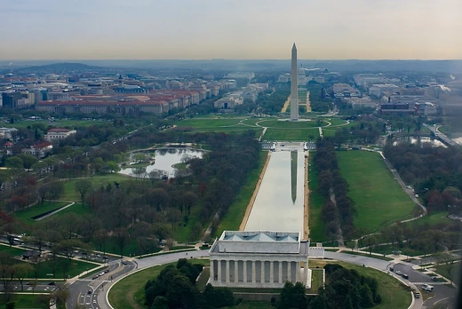
East Potomac Park
Man-made island park with golf, pools, and cherry trees.
Last updated

via Wikipedia: East Potomac Park · see source
Where it is
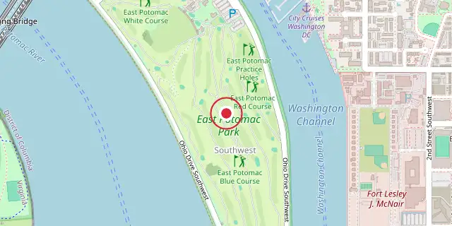
Coordinates: 38°52′12″N 77°01′34″W (38.8700, -77.0260) · Open in OpenStreetMap
Coordinates and connected clubs: the infobox of Wikipedia: East Potomac Park (CC BY-SA 4.0). Map: drawn by Codexery from OpenStreetMap tiles.
East Potomac Park sits on a man-made island in the Potomac River, southeast of the Jefferson Memorial and the 14th Street Bridge. The island separates the Washington Channel from the river.
The park offers a golf course, miniature golf, a public swimming pool, tennis courts, and athletic fields for baseball, soccer, and other sports. Its roads and paths are busy with cyclists, runners, and skaters, and fishing is popular. Ohio Drive SW borders the park, and the southern tip is Hains Point.
History
Even after the island was considered finished, workers kept filling in East Potomac Park. In 1906, a large oval hole about 14 acres wide sat in the middle of the island. The Army Corps of Engineers thought it was too far from the shore to fill, but a contractor who wanted to get rid of dredged material did the job for free in 1908. By 1910, part of the park was used as a nursery, growing trees, shrubs, and flowers for Congress, the White House, and other government offices.
In August 1912, Congress let the Corps open the park to the public. The next month, the Corps started building a 30-foot road along the Potomac River shoreline. Work on that road continued in 1914 and then moved up the Washington Channel side. The Channel-side road was finished in spring 1915, and the temporary road around the island’s southern tip was completed in late June 1915.
On August 1, 1914, Congress shifted control of the park from the federal government to the District of Columbia, but since the Corps oversaw D.C. public works, the park stayed under their authority. In spring 1915, the Corps did the first major landscaping, planting 46,650 shrubs and flowering plants and 203 Japanese cherry trees along the roadway. Another 133 cherry trees went in during spring 1916. One of the park’s first buildings was a lodge.
The Corps had wanted to build a small lodge in 1908 for tools, a public toilet, and a police shelter, but Congress said no. Instead, a lodge built in Franklin Square around 1867 was moved to the north end of the park, near the Washington Channel, between 1913 and June 1915. The National Park Service used it for various purposes until 1965, when Congress established the National Mall and Memorial Parks unit.
Geography
The island is positioned between the Washington Channel and the Potomac River. Its southern end, Hains Point, sits at the confluence of the Potomac and Anacostia rivers. Across the Washington Channel on the eastern shore are Fort Lesley McNair and the National War College, while Bolling Air Force Base lies across the Anacostia River. The Jefferson Memorial is at the northern end, and to the southwest, across the Potomac in Virginia, is Ronald Reagan Washington National Airport.
East Potomac Park falls under the jurisdiction of the National Mall and Memorial Parks unit of the National Park Service. The 330-acre park contains the East Potomac Golf Club and East Potomac Swimming Pool, along with many of Washington's famous cherry trees that extend to Hains Point. A concrete walking and bike path lines the park's perimeter, though the Potomac and Anacostia rivers often overflow their banks during high tide, covering the path.
Ohio Drive forms a one-way loop along the perimeter, with traffic traveling clockwise; various cherry tree cultivars line both sides of the road. Buckeye Drive bisects the peninsula, connecting the north and south portions of Ohio Drive. The terrain is flat, rising to only about 10 ft.
Construction
Before 1834, no one had formally recorded the shoals, sandbars, and marsh flats that likely lined the Potomac River shoreline in Washington, D.C. That year, the U.S. Army Corps of Topographical Engineers mapped extensive tidal flats below Long Bridge, the earlier version of today’s 14th Street Bridge. The largest of these flats measured 100 acres at low tide, and by 1881 they stretched from near the Old Naval Observatory down to Buzzard Point. At what is now 17th Street NW and Constitution Avenue NW, the city’s sewers emptied into a tidal flat called Kidwell’s Meadows.
The sewage, exposed to air about half the time, rotted and produced a powerful, rank odor. The southern Pennsylvania Avenue district suffered major floods in October 1870, February 1881, November 1887, and June 1889. After the 1881 flood, the Army Corps of Engineers dredged a deep channel in the Potomac and used the material to fill the river, creating the current banks and raising land near the White House and along Pennsylvania Avenue NW by nearly 6 feet.
Most of the dredged material went into building up existing tidal flats and sandbars, including those around Long Bridge. The reclamation happened in three stages: Section 1 became 135-acre West Potomac Park, section 2 became the 277-acre area around the Tidal Basin, and section 3 became 327-acre East Potomac Park. On March 3, 1897, Congress officially designated these areas Potomac Park. To prevent erosion, poplars and willows were planted along the island’s edge.
For the next two decades, East Potomac Park remained largely untouched, growing into dense thickets of trees and brush. Dredging continued after the park was considered finished, with additional material added in 1900, 1901, 1902, 1903, 1904, and 1907.
Did You Know?
- A lodge originally built in Franklin Square around 1867 was moved to the park between 1913 and June 1915, serving as the National Park Service's headquarters after 1965.
- The park's roads are closed to traffic on weekends and some holidays on the stretch between Buckeye Drive and Hains Point, a 3.2-mile loop popular with cyclists and skaters.
More in National Park Service Areas in Washington, D.C.
Sources
Compiled from Wikipedia and the sources listed below. Text from Wikipedia is available under CC BY-SA 4.0; this entry is adapted from it.
- Wikipedia: East Potomac Park (CC BY-SA 4.0).
Spotted an error? Know more?
Reader corrections go straight into our review queue. Suggest an edit · How this site is sourced